Boyd County, New South Wales
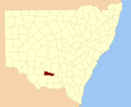
Boyd County is one of the 141 Cadastral divisions of New South Wales. It contains the locality of Coleambally. The Murrumbidgee River is the northern boundary.
| Boyd New South Wales | |||||||||||||||
|---|---|---|---|---|---|---|---|---|---|---|---|---|---|---|---|
 Location in New South Wales | |||||||||||||||
| |||||||||||||||
.png)
Boyd County NSW as shown on John Sands 1886 map).[1]
Boyd County was named in honour of Benjamin Boyd, entrepreneur (1796-1851).[2]
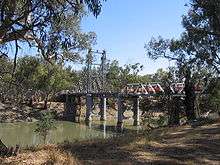
The Carathool Bridge over the Murrumbidgee between Boyd and Sturt
Parishes within this county
A full list of parishes found within this county; their current LGA and mapping coordinates to the approximate centre of each location is as follows:
gollark: &save me from qualitybot
gollark: The fun thing is that the desktop app is probably just the web app with its own Chrome instance.
gollark: Although we had those for 3.3 time.
gollark: Heavserver has stage channels. Maybe it dislikes them.
gollark: Is it in any new guilds? Did heavserver beeize it somehow?
References
- The New atlas of Australia (John Sands 1886) map 21.
- "Boyd County". Geographical Names Register (GNR) of NSW. Geographical Names Board of New South Wales.

This article is issued from Wikipedia. The text is licensed under Creative Commons - Attribution - Sharealike. Additional terms may apply for the media files.