Cooper County, New South Wales
Cooper County is one of the 141 Cadastral divisions of New South Wales. It contains the town of Barellan. The Murrumbidgee River is the southern boundary.
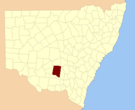
| Cooper New South Wales | |||||||||||||||
|---|---|---|---|---|---|---|---|---|---|---|---|---|---|---|---|
 Location in New South Wales | |||||||||||||||
| |||||||||||||||
Cooper County was named in honour of the merchant and philanthropist Sir Daniel Cooper (1821-1902).[1]
Parishes within this county
.png)
Cooper County NSW as shown on John Sands 1886 map)[2]
A full list of parishes found within this county; their current LGA and mapping coordinates to the approximate centre of each location is as follows:
| Parish | LGA | Coordinates |
|---|---|---|
| Ariah | Bland Shire Council | 34°03′54″S 146°42′04″E |
| Barellan | Narrandera Shire Council | 34°13′54″S 146°29′04″E |
| Barralong | Narrandera Shire Council | 34°20′54″S 146°33′04″E |
| Beremabere | Narrandera Shire Council | 34°32′54″S 146°34′04″E |
| Bingar | Carrathool Shire Council | 34°07′54″S 146°12′04″E |
| Binya | Carrathool Shire Council | 34°12′54″S 146°18′04″E |
| Bogolong | Narrandera Shire Council | 34°39′54″S 146°43′04″E |
| Bolaro | Narrandera Shire Council | 34°27′54″S 146°44′04″E |
| Bondi | Leeton Shire Council | 34°21′54″S 146°16′04″E |
| Bourke | Bland Shire Council | 33°56′54″S 146°24′04″E |
| Bourke | Carrathool Shire Council | 33°56′54″S 146°25′04″E |
| Bringan | Carrathool Shire Council | 34°27′54″S 146°09′04″E |
| Brobenah | Narrandera Shire Council | 34°26′54″S 146°28′04″E |
| Bundidgerry | Narrandera Shire Council | 34°43′54″S 146°38′04″E |
| Bunganbil | Narrandera Shire Council | 34°26′54″S 146°37′04″E |
| Bygoo | Bland Shire Council | 34°07′54″S 146°48′04″E |
| Camarooka | Carrathool Shire Council | 34°23′54″S 146°02′04″E |
| Cocoparra | Carrathool Shire Council | 33°46′54″S 146°09′04″E |
| Colaragang | Carrathool Shire Council | 34°31′54″S 146°00′04″E |
| Colchester | Carrathool Shire Council | 34°23′54″S 146°09′04″E |
| Conapaira | Carrathool Shire Council | 33°50′54″S 146°16′04″E |
| Conapaira East | Bland Shire Council | 33°49′54″S 146°23′04″E |
| Conapaira South | Carrathool Shire Council | 33°55′54″S 146°17′04″E |
| Cuba | Carrathool Shire Council | 34°32′54″S 146°05′04″E |
| Cudgel | Leeton Shire Council | 34°37′54″S 146°29′04″E |
| Cudjello | Narrandera Shire Council | 34°37′54″S 146°34′04″E |
| Dallas | Carrathool Shire Council | 34°35′54″S 146°14′04″E |
| Dowling | Bland Shire Council | 34°05′54″S 146°36′04″E |
| Edon | Leeton Shire Council | 34°26′54″S 146°22′04″E |
| Euratha | Bland Shire Council | 33°46′54″S 146°32′04″E |
| Euratha South | Bland Shire Council | 33°52′54″S 146°31′04″E |
| Garoolgan | Narrandera Shire Council | 34°10′54″S 146°33′04″E |
| Gibbs | Narrandera Shire Council | 34°21′54″S 146°22′04″E |
| Gogeldrie | Leeton Shire Council | 34°36′54″S 146°20′04″E |
| Gorton | Carrathool Shire Council | 34°20′54″S 146°10′04″E |
| Grong Grong | Narrandera Shire Council | 34°45′54″S 146°42′04″E |
| Gurragong | Bland Shire Council | 33°54′54″S 146°38′04″E |
| Hebden | Leeton Shire Council | 34°25′54″S 146°15′04″E |
| Hulong | Carrathool Shire Council | 34°34′54″S 146°08′04″E |
| Jondaryan | City of Griffith | 34°18′54″S 146°04′04″E |
| Kolkilbertoo | Bland Shire Council | 33°58′54″S 146°32′04″E |
| Kolkilbertoo East | Bland Shire Council | 33°59′54″S 146°36′04″E |
| Kolkilbertoo South | Bland Shire Council | 34°05′54″S 146°30′04″E |
| Lewes | Bland Shire Council | 33°58′54″S 146°43′04″E |
| Mejum | Narrandera Shire Council | 34°38′54″S 146°39′04″E |
| Moombooldool | Narrandera Shire Council | 34°21′54″S 146°40′04″E |
| Moombooldool North | Narrandera Shire Council | 34°16′54″S 146°40′04″E |
| Moura | Narrandera Shire Council | 34°17′54″S 146°23′04″E |
| Munduburra | Bland Shire Council | 33°49′54″S 146°38′04″E |
| Munduburra | Bland Shire Council | 33°50′54″S 146°38′04″E |
| Narrandera | Narrandera Shire Council | 34°42′54″S 146°33′04″E |
| Narriah | Bland Shire Council | 33°51′54″S 146°44′04″E |
| Narriah | Bland Shire Council | 33°50′54″S 146°44′04″E |
| Naunton | Carrathool Shire Council | 34°27′54″S 146°06′04″E |
| North Bolaro | Narrandera Shire Council | 34°21′54″S 146°45′04″E |
| Oxley | Narrandera Shire Council | 34°07′54″S 146°24′04″E |
| Patterson | Narrandera Shire Council | 34°12′54″S 146°24′04″E |
| Pulletop | Carrathool Shire Council | 33°56′54″S 146°08′04″E |
| Sandy Creek | Bland Shire Council | 34°09′54″S 146°41′04″E |
| Sims Gap | Carrathool Shire Council | 33°51′54″S 146°08′04″E |
| Stanbridge | City of Griffith | 34°15′54″S 146°11′04″E |
| Stanley | Carrathool Shire Council | 34°06′54″S 146°18′04″E |
| Tabbita | Carrathool Shire Council | 34°06′54″S 146°06′04″E |
| Tabbita North | Carrathool Shire Council | 34°01′54″S 146°08′04″E |
| Tenningerie | Leeton Shire Council | 34°29′54″S 146°15′04″E |
| The Bluff | Carrathool Shire Council | 34°01′54″S 146°16′04″E |
| The Peak | Carrathool Shire Council | 34°02′54″S 146°25′04″E |
| Tuckerbil | Leeton Shire Council | 34°30′54″S 146°20′04″E |
| Wallandry | Bland Shire Council | 34°00′54″S 146°48′04″E |
| Wallandry North | Bland Shire Council | 33°54′54″S 146°50′04″E |
| Wammera | Narrandera Shire Council | 34°33′54″S 146°40′04″E |
| Watti | Narrandera Shire Council | 34°34′54″S 146°44′04″E |
| Waugh | Narrandera Shire Council | 34°20′54″S 146°29′04″E |
| Willbriggie | Carrathool Shire Council | 34°27′54″S 146°01′04″E |
| Willimbong | Leeton Shire Council | 34°32′54″S 146°28′04″E |
| Wyangan | City of Griffith | 34°12′54″S 146°05′04″E |
| Yalgogoring | Bland Shire Council | 34°14′54″S 146°47′04″E |
| Yarangery | Leeton Shire Council | 34°36′54″S 146°25′04″E |
| Yenda | City of Griffith | 34°17′54″S 146°17′04″E |
gollark: It could probably be worked in during restarts.
gollark: Apparently Netflix have a thing to randomly crash production machines to ensure everything still works if they do.
gollark: In the case of RAID1ing SSDs, 120GB ones are probably cheap enough that it makes sense for this.
gollark: As I said, you obviously *want* high uptime, but sometimes the tradeoffs aren't worth it.
gollark: "Dedicated server" basically just means it's on a dedicated machine.
References
- "Cooper County". Geographical Names Register (GNR) of NSW. Geographical Names Board of New South Wales.

- The New atlas of Australia (John Sands 1886) map 21.
This article is issued from Wikipedia. The text is licensed under Creative Commons - Attribution - Sharealike. Additional terms may apply for the media files.