Clarence County
Clarence County is one of the 141 Cadastral divisions of New South Wales. It lies to the north of the Orara River, and includes the mouth of the Clarence River, and the city of Grafton.
| Clarence New South Wales | |||||||||||||||
|---|---|---|---|---|---|---|---|---|---|---|---|---|---|---|---|
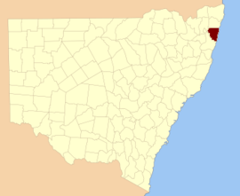 Location in New South Wales | |||||||||||||||
| |||||||||||||||
Clarence County is named in honour of the Duke of Clarence – William IV (1765-1837).[1]
Parishes within this county
A full list of parishes found within this county; their current LGA and mapping coordinates to the approximate centre of each location is as follows:
gollark: True.
gollark: And I can influence its RNG via apiohax™.
gollark: Well, ABR is the maximally good bot.
gollark: IPoAC in action.
gollark: https://generative.ink/alternet/files/carrierpigeon2.png
References
- "Clarence County". Geographical Names Register (GNR) of NSW. Geographical Names Board of New South Wales.

This article is issued from Wikipedia. The text is licensed under Creative Commons - Attribution - Sharealike. Additional terms may apply for the media files.