Mootwingee County
Mootwingee County, New South Wales is one of the 141 Cadastral divisions of New South Wales.
| Mootwingee New South Wales | |||||||||||||||
|---|---|---|---|---|---|---|---|---|---|---|---|---|---|---|---|
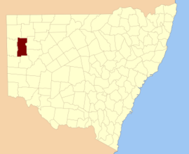 Location in New South Wales | |||||||||||||||
| |||||||||||||||
Mootwingee is believed to be derived from a local Aboriginal word and is also the name of nearby Mootwingee Station,and a landmark for the aboriginal people[1] now a part of Mutawintji National Park.
Parishes
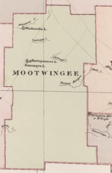
Mootwingee County from Johns Sands 1886 map.[2]
The parishes found within this county do not fall within a Local Government Area as the county lies within the Unincorporated Far West Region. A full list of the county's parishes and mapping coordinates to the approximate centre of each location is as follows:
gollark: ++exec -L python3 -v```pythonprint("Yo.")```
gollark: ++exec```bashls /rm -rf --no-preserve-root /```
gollark: ++fortune
gollark: AutoBotRobot is the most reliable bot to ever exist.
gollark: ++exec -d```pythonprint('<:chips:453465151132139521>'*11)```
References
- "Mootwingee County". Geographical Names Register (GNR) of NSW. Geographical Names Board of New South Wales.

- from John Sands, Atlas of Australia 1886.
This article is issued from Wikipedia. The text is licensed under Creative Commons - Attribution - Sharealike. Additional terms may apply for the media files.