Brisbane County

Brisbane County was one of the original Nineteen Counties in New South Wales and is now one of the 141 Cadastral divisions of New South Wales. It includes Scone, Merriwa and Murrurundi. The Goulburn River is the boundary to the south and the Hunter River the boundary to the south-east. The Liverpool Range area is the boundary to the north, and the Krui River the boundary to the west.

Brisbane
New South Wales
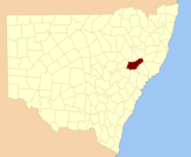
Location in New South Wales
Lands administrative divisions around Brisbane:
Pottinger Buckland Parry
Bligh Brisbane Hawes
Phillip Hunter Durham

Brisbane County was named in honour of Sir Thomas Makdougall Brisbane Governor (1773-1860).[1] The Electoral district of Phillip, Brisbane and Bligh was the first electoral district for the area, between 1856 and 1859.

Parishes within this county

A full list of parishes found within this county; their current LGA and mapping coordinates to the approximate centre of each location is as follows:

ParishLGACoordinates
AilsaUpper Hunter Shire32°03′54″S 150°11′04″E
AlmaUpper Hunter Shire32°02′54″S 150°59′04″E
BoggibriUpper Hunter Shire32°02′54″S 150°16′04″E
BrawboyUpper Hunter Shire32°01′54″S 150°41′04″E
BroghedaMuswellbrook Shire32°11′54″S 150°43′04″E
CampbellUpper Hunter Shire32°17′54″S 150°18′04″E
Castle SempillUpper Hunter Shire31°51′54″S 151°13′04″E
ChersonUpper Hunter Shire31°55′54″S 151°07′04″E
ClanricardMuswellbrook Shire32°14′54″S 150°45′04″E
CoulsonUpper Hunter Shire31°58′54″S 150°24′04″E
CranbourneUpper Hunter Shire32°00′54″S 150°19′04″E
CrawneyUpper Hunter Shire31°44′54″S 151°08′04″E
DangarMuswellbrook Shire32°21′54″S 150°27′04″E
DenmanMuswellbrook Shire32°21′54″S 150°40′04″E
EllerstonUpper Hunter Shire31°45′54″S 151°13′04″E
EllisMuswellbrook Shire32°12′54″S 150°50′04″E
GoulburnUpper Hunter Shire32°19′54″S 150°23′04″E
Guan GuaUpper Hunter Shire32°05′54″S 150°41′04″E
Gundy GundyUpper Hunter Shire32°00′54″S 150°58′04″E
HallUpper Hunter Shire32°10′54″S 150°32′04″E
HalscotUpper Hunter Shire32°08′54″S 150°47′04″E
HowardUpper Hunter Shire32°06′54″S 150°19′04″E
IsisUpper Hunter Shire31°49′54″S 151°01′04″E
KilloeUpper Hunter Shire32°06′54″S 150°10′04″E
LincolnUpper Hunter Shire31°39′54″S 151°03′04″E
MackenzieUpper Hunter Shire32°15′54″S 150°22′04″E
MacqueenUpper Hunter Shire32°07′54″S 150°57′04″E
ManbusUpper Hunter Shire32°01′54″S 150°46′04″E
ManobalaiMuswellbrook Shire32°11′54″S 150°36′04″E
MelbourneUpper Hunter Shire31°59′54″S 150°49′04″E
MerriwaUpper Hunter Shire32°09′54″S 150°24′04″E
MurrurundiUpper Hunter Shire31°45′54″S 150°48′04″E
MurullaUpper Hunter Shire31°47′54″S 150°55′04″E
MyrabluanUpper Hunter Shire32°07′54″S 150°35′04″E
NerobingablaUpper Hunter Shire31°55′54″S 150°36′04″E
OxleyUpper Hunter Shire31°55′49″S 150°19′35″E
PageUpper Hunter Shire31°54′54″S 150°58′04″E
ParkUpper Hunter Shire32°00′54″S 150°53′04″E
SconeUpper Hunter Shire32°02′54″S 150°50′04″E
StrathearnUpper Hunter Shire32°08′54″S 150°51′04″E
TemiUpper Hunter Shire31°41′54″S 150°55′04″E
TerellUpper Hunter Shire31°55′54″S 150°30′04″E
TimorUpper Hunter Shire31°46′54″S 151°02′04″E
TinagrooUpper Hunter Shire31°49′54″S 150°49′04″E
TongoUpper Hunter Shire32°10′54″S 150°10′04″E
TyroneUpper Hunter Shire32°03′54″S 150°38′04″E
WandewoiUpper Hunter Shire31°44′54″S 151°20′04″E
WattUpper Hunter Shire32°10′54″S 150°17′04″E
WaverlyUpper Hunter Shire31°50′54″S 151°08′04″E
WebimbleUpper Hunter Shire32°02′54″S 150°32′04″E
WentworthUpper Hunter Shire31°54′54″S 150°26′04″E
WickhamUpper Hunter Shire32°14′54″S 150°31′04″E
WillisUpper Hunter Shire31°53′54″S 150°43′04″E
WingenUpper Hunter Shire31°53′54″S 150°51′04″E
WollaraUpper Hunter Shire32°13′54″S 150°12′04″E
WorondiUpper Hunter Shire32°17′54″S 150°27′04″E
WybongMuswellbrook Shire32°14′54″S 150°40′04″E
YarramanMuswellbrook Shire32°14′54″S 150°37′04″E
gollark: Did you know? There have been many incidents in the past where improper apiary safety protocols have lead to unbounded tetrational apiogenesis, also referred to as a VK-class "universal apiary" scenario. Often, the fallout from this needs to be cleaned up by moving all sentient entities into identical simulated universes, save for the incident occurring. This is known as "retroactive continuity", and modern apiaries' safety systems provide this functionality automatically.
gollark: I am not in any way a pizza, related to pizza, or advertising pizzas. I have had no commercial or personal relations with pizza companies, and do not, in fact, regularly eat pizza. I am not engaged in any form of pizza advertising, subliminal or otherwise. Any claims to the contrary will be considered wrong and bad, and should not be promulgated.
gollark: Wow, the sheer activity.
gollark: ↓ you
gollark: Bees will be caused to rotate as an inevitable consequence.

References

  1. "Brisbane County". Geographical Names Register (GNR) of NSW. Geographical Names Board of New South Wales.
This article is issued from Wikipedia. The text is licensed under Creative Commons - Attribution - Sharealike. Additional terms may apply for the media files.