Waljeers County

Waljeers County is one of the 141 Cadastral divisions of New South Wales. It contains the town of Booligal.

Waljeers
New South Wales
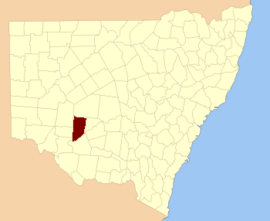
Location in New South Wales
Lands administrative divisions around Waljeers:
Manara Mossgiel Mossgiel
Kilfera Waljeers Franklin
Caira Waradgery Nicholson

The name Waljeers is derived from a local Aboriginal word of the Muthi Muthi tribe.[1]

Lake Waljeers is one of largest lakes located north of the Lachlan River and the river crossing at Thellangering.

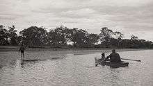
Fishing on Lake Waljeers

Parishes within this county

A full list of parishes found within this county; their current LGA and mapping coordinates to the approximate centre of each location is as follows:

ParishLGACoordinates
AbbotsfordCentral Darling Shire33°13′50″S 144°19′26″E
AlmaBalranald Shire33°23′34″S 144°16′18″E
AnnanCarrathool Shire33°21′04″S 144°39′15″E
ArrawattaBalranald Shire33°43′41″S 144°28′14″E
AvondaleCarrathool Shire33°24′02″S 144°25′43″E
BenanimieHay Shire33°51′50″S 144°49′35″E
BillabongCarrathool Shire33°20′21″S 144°25′52″E
BoondaraCarrathool Shire33°17′23″S 144°39′13″E
BrassbuttBalranald Shire34°07′21″S 144°23′39″E
BuckonyongBalranald Shire34°06′37″S 144°09′18″E
BulgarbugerygamBalranald Shire33°42′33″S 144°14′07″E
BullogalBalranald Shire33°55′09″S 144°31′18″E
BungarryBalranald Shire34°03′30″S 144°17′00″E
CampbellCarrathool Shire33°29′14″S 144°30′18″E
CarnghamHay Shire33°32′02″S 144°37′36″E
CorrongBalranald Shire34°09′20″S 144°29′39″E
CulparlingBalranald Shire33°30′33″S 144°15′37″E
CulpataroBalranald Shire33°37′36″S 144°23′51″E
DimboolaBalranald Shire33°57′34″S 144°28′54″E
EllislandBalranald Shire33°16′40″S 144°18′56″E
Goona WarraHay Shire33°59′57″S 144°39′07″E
GregoryBalranald Shire33°56′28″S 144°10′41″E
HowatsonCarrathool Shire33°20′35″S 144°46′29″E
KingswellHay Shire33°34′27″S 144°44′50″E
LaganBalranald Shire34°05′09″S 144°23′59″E
LargsCarrathool Shire33°21′03″S 144°32′01″E
LarnacaHay Shire33°35′46″S 144°34′53″E
LowanCentral Darling Shire33°14′09″S 144°29′03″E
MarowieBalranald Shire33°52′18″S 144°26′53″E
MassieHay Shire33°42′56″S 144°44′18″E
MatamongBalranald Shire34°03′36″S 144°29′21″E
MekaiCarrathool Shire33°22′51″S 144°45′57″E
MerrimajeelHay Shire33°55′29″S 144°37′39″E
MoodarnongHay Shire33°49′29″S 144°48′57″E
MossgielCentral Darling Shire33°10′56″S 144°35′50″E
MullogaBalranald Shire34°06′02″S 144°16′36″E
MurniaCarrathool Shire33°14′06″S 144°48′40″E
MurraHay Shire33°45′38″S 144°35′19″E
NandumBalranald Shire34°00′49″S 144°10′00″E
NatueHay Shire33°50′51″S 144°42′21″E
NyandaHay Shire33°48′42″S 144°42′51″E
PimparaBalranald Shire34°11′48″S 144°22′20″E
SebastopolBalranald Shire33°46′04″S 144°22′30″E
SimsonCentral Darling Shire
St AndrewHay Shire33°33′06″S 144°30′50″E
TarrawongBalranald Shire33°52′40″S 144°13′16″E
TartooHay Shire33°41′16″S 144°38′32″E
TinnaHay Shire33°47′42″S 144°34′57″E
Toms LakeHay Shire33°38′17″S 144°45′04″E
ToopruckBalranald Shire34°13′41″S 144°15′47″E
TooralboungBalranald Shire34°10′16″S 144°09′00″E
TrawallaCentral Darling Shire33°12′12″S 144°44′25″E
TysonBalranald Shire33°50′08″S 144°22′20″E
WaljeersBalranald Shire34°03′10″S 144°36′27″E
WaverleyCarrathool Shire33°25′08″S 144°39′00″E
WickhamBalranald Shire33°27′51″S 144°16′03″E
WillandraCentral Darling Shire33°09′18″S 144°20′11″E
WyungaBalranald Shire34°00′37″S 144°20′14″E
YalooHay Shire33°57′06″S 144°44′07″E
YartoHay Shire33°27′26″S 144°45′58″E
gollark: That's your fault.
gollark: Imagine it as an infinite binary tree.
gollark: They can have half the squares but the same total number quite easily.
gollark: Good point, "Lyricly" macron.
gollark: Oh, right, you don't want it to be backward-sorted either, yes.

References

  1. "Waljeers". Geographical Names Register (GNR) of NSW. Geographical Names Board of New South Wales. Retrieved 11 August 2013.
This article is issued from Wikipedia. The text is licensed under Creative Commons - Attribution - Sharealike. Additional terms may apply for the media files.