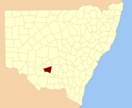
Sturt County
Sturt County is one of the 141 Cadastral divisions of New South Wales. It contains the locality of Carrathool. The Murrumbidgee River is the southern boundary.
| Sturt New South Wales | |||||||||||||||
|---|---|---|---|---|---|---|---|---|---|---|---|---|---|---|---|
 Location in New South Wales | |||||||||||||||
| |||||||||||||||
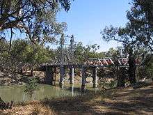
The Carathool Bridge over the Murrumbidgee between Sturt and Boyd
.png)
Sturt County NSW as shown on John Sands 1886 map)[1]
Sturt County was named in honour of the explorer, soldier and public servant Charles Sturt (1795-1869).[2]
Parishes within this county
A full list of parishes found within this county; their current LGA and mapping coordinates to the approximate centre of each location is as follows:
| Parish | LGA | Coordinates |
|---|---|---|
| Alleyne | Carrathool Shire Council | 34°18′54″S 145°28′04″E |
| Baillie | City of Griffith | 34°22′54″S 145°55′04″E |
| Ballingall | City of Griffith | 34°13′54″S 146°00′04″E |
| Beabula | Hay Shire Council | 34°13′54″S 145°11′04″E |
| Bendigo | City of Griffith | 34°21′54″S 145°47′04″E |
| Benerembah | Carrathool Shire Council | 34°28′54″S 145°55′04″E |
| Bringagee | Carrathool Shire Council | 34°25′54″S 145°45′04″E |
| Buckley | Carrathool Shire Council | 34°09′54″S 145°29′04″E |
| Cajaldura | Carrathool Shire Council | 34°23′54″S 145°34′04″E |
| Carrathool | Carrathool Shire Council | 34°22′54″S 145°30′04″E |
| Carrego | Carrathool Shire Council | 34°05′54″S 145°28′04″E |
| Cockburn | Carrathool Shire Council | 34°08′54″S 145°44′04″E |
| Denny | Carrathool Shire Council | 34°02′54″S 145°51′04″E |
| Djallah | City of Griffith | 34°23′54″S 145°51′04″E |
| Downey | Hay Shire Council | 34°11′54″S 145°09′04″E |
| Ercildoune | Carrathool Shire Council | 34°18′54″S 145°35′04″E |
| Hervey | Carrathool Shire Council | 34°10′54″S 145°42′04″E |
| Houlong | Carrathool Shire Council | 34°21′54″S 145°23′04″E |
| Hyde Park | Carrathool Shire Council | 34°18′54″S 145°41′04″E |
| Kooba | Carrathool Shire Council | 34°04′54″S 146°00′04″E |
| Kooroongal | Carrathool Shire Council | 34°23′54″S 145°40′04″E |
| Learmonth | City of Griffith | 34°15′54″S 145°48′04″E |
| Lethington | Carrathool Shire Council | 34°11′54″S 145°26′04″E |
| Livingstone | Carrathool Shire Council | 34°05′54″S 145°37′04″E |
| Maiden | Carrathool Shire Council | 34°02′54″S 145°43′04″E |
| Mair | Carrathool Shire Council | 34°10′54″S 145°37′04″E |
| Mills | Carrathool Shire Council | 34°07′54″S 145°19′04″E |
| Mirrool | City of Griffith | 34°08′54″S 146°02′04″E |
| Munro | Carrathool Shire Council | 34°02′54″S 145°55′04″E |
| North Bringagee | City of Griffith | 34°09′54″S 145°49′04″E |
| North Uardry | Carrathool Shire Council | 34°12′54″S 145°19′04″E |
| O'Brien | City of Griffith | 33°59′54″S 145°53′04″E |
| Quambatook | Carrathool Shire Council | 34°14′54″S 145°36′04″E |
| Tabbita | Carrathool Shire Council | 33°54′54″S 146°02′04″E |
| Tabbita | Carrathool Shire Council | 33°56′54″S 145°57′04″E |
| Terrapee | Carrathool Shire Council | 34°13′54″S 145°31′04″E |
| Toms Point | Carrathool Shire Council | 34°29′54″S 145°14′04″E |
| Uardry | Carrathool Shire Council | 34°20′54″S 145°18′04″E |
| Warburn | City of Griffith | 34°16′54″S 145°53′04″E |
| Wiveon | Carrathool Shire Council | 34°14′54″S 145°42′04″E |
| Wowong | Carrathool Shire Council | 34°28′54″S 145°50′04″E |
| Wycheproof | Carrathool Shire Council | 34°04′54″S 145°32′04″E |
| Yannaway | Carrathool Shire Council | 34°13′54″S 145°25′04″E |
gollark: No. I'm very busy being distracted from everything ever.
gollark: Idea: computer vision to autodetect and memeticize "amogus" in arbitrary image collections.
gollark: No.
gollark: What? Does that mean something?
gollark: By 2025, based on my regression model.
References
- The New atlas of Australia (John Sands 1886) map 21.
- "Sturt County". Geographical Names Register (GNR) of NSW. Geographical Names Board of New South Wales.

This article is issued from Wikipedia. The text is licensed under Creative Commons - Attribution - Sharealike. Additional terms may apply for the media files.