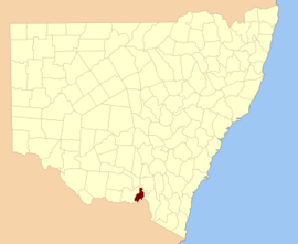
Goulburn County
Goulburn County is one of the 141 Cadastral divisions of New South Wales. It contains the city of Albury, and the towns of Jindera, Bowna and Woomargama.
| Goulburn New South Wales | |||||||||||||||
|---|---|---|---|---|---|---|---|---|---|---|---|---|---|---|---|
 Location in New South Wales | |||||||||||||||
| |||||||||||||||
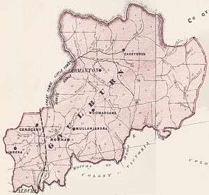
1886 map of Goulburn county
Goulburn County was named in honour of the statesman, Henry Goulburn (1784-1856).[1]
Parishes within this county
A full list of parishes found within this county; their current LGA and mapping coordinates to the approximate centre of each location is as follows:
| Parish | LGA | Coordinates |
|---|---|---|
| Albury | City of Albury | 36°02′54″S 146°54′04″E |
| Back Creek | Greater Hume Shire Council | 35°37′54″S 147°21′04″E |
| Billabung | Greater Hume Shire Council | 35°37′54″S 147°30′04″E |
| Bowna | Greater Hume Shire Council | 35°59′54″S 146°03′04″E |
| Carabobala | Greater Hume Shire Council | 35°40′54″S 147°15′04″E |
| Carabost | Greater Hume Shire Council | 35°35′54″S 147°33′04″E |
| Coocook | Greater Hume Shire Council | 35°43′54″S 147°33′04″E |
| Cookardinia | Greater Hume Shire Council | 35°35′54″S 147°15′04″E |
| Coppabella | Greater Hume Shire Council | 35°44′54″S 147°42′04″E |
| Cumboroona | Greater Hume Shire Council | 35°58′54″S 147°12′04″E |
| Currajong | Greater Hume Shire Council | 35°50′54″S 147°38′04″E |
| Dora Dora | Greater Hume Shire Council | 35°51′54″S 147°23′04″E |
| Forest Creek | Greater Hume Shire Council | 35°34′54″S 147°30′04″E |
| Gerogery | Greater Hume Shire Council | 35°52′24″S 147°01′04″E |
| Holbrook | Greater Hume Shire Council | 35°42′54″S 147°20′04″E |
| Hume | Greater Hume Shire Council | 35°52′54″S 147°15′04″E |
| Huon | Greater Hume Shire Council | 35°52′54″S 146°55′04″E |
| Jergyle | Greater Hume Shire Council | 35°48′54″S 147°23′04″E |
| Jerra Jerra | Greater Hume Shire Council | 35°28′54″S 147°13′04″E |
| Jindera | Greater Hume Shire Council | 35°57′54″S 146°55′04″E |
| Jingellic | Greater Hume Shire Council | 35°54′54″S 147°39′04″E |
| Little Billabung | Greater Hume Shire Council | 35°29′54″S 147°31′04″E |
| Mitchell | Greater Hume Shire Council | 35°47′54″S 147°18′04″E |
| Mountain Creek | Greater Hume Shire Council | 35°46′54″S 147°15′04″E |
| Mullengandra | Greater Hume Shire Council | 35°53′54″S 147°11′04″E |
| Mungabarina | Greater Hume Shire Council | 35°01′54″S 146°57′04″E |
| Murray | Greater Hume Shire Council | 35°37′24″S 147°32′04″E |
| Narra Narra Wa | Greater Hume Shire Council | 35°47′54″S 147°32′04″E |
| Pulletop | Greater Hume Shire Council | 35°33′54″S 147°21′04″E |
| Talmalmo | Greater Hume Shire Council | 35°51′54″S 147°33′04″E |
| Thurgoona | City of Albury | 36°03′54″S 147°00′04″E |
| Vautier | Greater Hume Shire Council | 35°51′54″S 147°30′04″E |
| Wagra | Greater Hume Shire Council | 35°58′54″S 147°15′04″E |
| Woomargama | Greater Hume Shire Council | 35°48′54″S 147°10′04″E |
| Wyndham | Greater Hume Shire Council | 35°56′54″S 147°07′04″E |
| Yambla | Greater Hume Shire Council | 35°55′54″S 147°01′04″E |
| Yarara | Greater Hume Shire Council | 35°41′54″S 147°39′04″E |
| Yarra Yarra | Greater Hume Shire Council | 35°42′54″S 147°27′04″E |
gollark: They didn't make any core designs, bee.
gollark: It's an older high-power one.
gollark: Also no crypto acceleration.
gollark: Probably half the performance or worse, plus it only has the A72s and no A55s like this.
gollark: It has A72s, so bad.
References
- "Goulburn County". Geographical Names Register (GNR) of NSW. Geographical Names Board of New South Wales.

This article is issued from Wikipedia. The text is licensed under Creative Commons - Attribution - Sharealike. Additional terms may apply for the media files.