Irrara County

Irrara County is one of the 141 Cadastral divisions of New South Wales. It is located south of the border with Queensland, east of the Paroo River, and west of the Warrego River.

Irrara
New South Wales
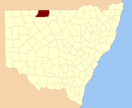
Location in New South Wales
Lands administrative divisions around Irrara:
Queensland Queensland Queensland
Thoulcanna Irrara Culgoa
Ularara Barrona Gunderbooka

Irrara County has now towns of any size. The only settlements are the localities of Yantabulla, New South Wales and Fords Bridge, New South Wales. Yantabulla has been noted as being the future location of the rare double-sighting of solar eclipses within short intervals of one another.[1]

Barringun, Queensland at the north eastern corner of the County, Hungerford, Queensland at the north west corner of the county Enngonia, New South Wales and Waanaring, New South Wales at the south west corner of the county all lie just outside the county.

Irrara is believed to be derived from a local Aboriginal word. - Irrara Creek.[2]

Parishes within this county

A full list of parishes found within this county; their current LGA and mapping coordinates to the approximate centre of each location is as follows:

ParishLGACoordinates
ArdfertBourke Shire29°21′01″S 144°44′05″E
AshtonBourke Shire29°19′38″S 145°15′04″E
BantryBourke Shire29°20′38″S 145°23′00″E
BerawinniaUnincorporated29°01′44″S 144°24′13″E
BirrawarraBourke Shire29°16′19″S 145°13′38″E
BoomeryBourke Shire29°37′15″S 145°36′34″E
BoongunnyarraBourke Shire29°21′07″S 145°06′51″E
Lismore SouthBourke Shire29°38′46″S 144°55′36″E
LismoreBourke Shire29°28′51″S 144°56′06″E
ConroyBourke Shire29°22′45″S 145°42′01″E
CoonbillyBourke Shire29°30′39″S 145°13′50″E
DungarvanBourke Shire29°31′57″S 144°50′05″E
DwightBourke Shire29°06′16″S 145°39′04″E
EffluenceBourke Shireunknown
GibsonBourke Shire29°20′47″S 145°46′27″E
GlenampleBourke Shire29°02′17″S 145°05′54″E
GlenelgBourke Shire29°35′36″S 145°22′40″E
GrasmereBourke Shire29°32′59″S 144°38′27″E
IrraraBourke Shire29°12′51″S 145°25′36″E
KenmareBourke Shire29°15′17″S 144°55′31″E
KerribreeBourke Shire29°42′00″S 145°15′25″E
KilferaBourke Shire29°04′21″S 144°55′35″E
KillowenBourke Shire29°10′58″S 144°44′39″E
Manatoo WestBourke Shire29°38′48″S 144°37′18″E
ManatooBourke Shire29°42′51″S 144°45′10″E
MerritaBourke Shire29°42′41″S 145°06′04″E
Moco BarunghaBourke Shire29°10′14″S 145°36′11″E
MoolortBourke Shire29°07′23″S 144°45′27″E
MooroonowaBourke Shire29°04′52″S 145°25′46″E
MucrussBourke Shire29°21′51″S 144°56′31″E
MukudjerooBourke Shire29°14′10″S 145°04′24″E
MultagoonaBourke Shire29°27′18″S 145°32′04″E
Paroo PlainsBourke Shire29°42′20″S 144°29′00″E
Pelican PondsBourke Shire29°28′35″S 144°34′25″E
PenonigiaBourke Shire29°18′05″S 144°33′49″E
PoriallaBourke Shire29°02′18″S 145°16′21″E
ScottBourke Shire29°11′07″S 145°45′52″E
Stony RidgeUnincorporated29°28′59″S 144°17′56″E
TalyealyeBourke Shire29°11′37″S 144°30′42″E
TekaaraBourke Shire29°30′34″S 145°21′47″E
ThurnapatchaBourke Shire29°24′22″S 144°27′37″E
TyngnyniaBourke Shire29°15′20″S 144°37′18″E
WapweelahBourke Shire29°19′54″S 145°34′57″E
WarrooBourke Shire29°04′22″S 144°38′20″E
WillyerooBourke Shire29°43′28″S 145°25′19″E
YerncaBourke Shire29°34′09″S 144°23′49″E
YoungarigniaBourke Shire29°28′43″S 145°06′03″E
gollark: ext4, f2fs, btrfs or xfs?
gollark: Oh no. I am installing Linux and thus I am stuck investigating filesystem benchmarks again?!
gollark: How bad.
gollark: It is too late. I am installing Arch.
gollark: FEAR it.

References

This article is issued from Wikipedia. The text is licensed under Creative Commons - Attribution - Sharealike. Additional terms may apply for the media files.