Wellesley County
Wellesley County is one of the 141 Cadastral divisions of New South Wales. It is located along the border with Victoria, with the Snowy River part of the northern boundary. It includes Bombala.
| Wellesley New South Wales | |||||||||||||||
|---|---|---|---|---|---|---|---|---|---|---|---|---|---|---|---|
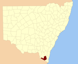 Location in New South Wales | |||||||||||||||
| |||||||||||||||
Wellesley County was named in honour of Governor General of India Richard Colley Wellesley, Marquis Wellesley (1760-1842).[1]
Parishes within this county
A full list of parishes found within this county; their current LGA and mapping coordinates to the approximate centre of each location is as follows:
gollark: I don't agree, trade is generally pretty positive-sum for everyone.
gollark: It would be more than "oh no, I have slightly worse food choices".
gollark: Full anarchoprimitivism, as komrad suggested, would *not* have that, and pre-industrial-revolution you have way worse productive capacity (so less of those things/worse things), and no access to modern medicine.
gollark: You still have access to presumably clean water of some form, the knowledge that you *can* go somewhere with that if you need medical treatment or whatever, and the ability to buy stuff if it's needed.
gollark: Or, I guess, for full monke™ any technology.
References
- "Wellesley". Geographical Names Register (GNR) of NSW. Geographical Names Board of New South Wales. Retrieved 11 August 2013.

This article is issued from Wikipedia. The text is licensed under Creative Commons - Attribution - Sharealike. Additional terms may apply for the media files.