Gunderbooka County
Gunderbooka County is one of the 141 Cadastral divisions of New South Wales. The Warrego River is the western boundary, and the Culgoa River and Darling River is the south-eastern boundary. It includes the area down to where the Warrego meets the Darling, to the north of Bourke (including North Bourke).
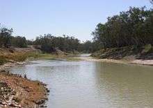
The Darling River is the boundary between Gunderbooka and Cowper.
| Gunderbooka New South Wales | |||||||||||||||
|---|---|---|---|---|---|---|---|---|---|---|---|---|---|---|---|
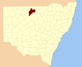 Location in New South Wales | |||||||||||||||
| |||||||||||||||
Gunderbooka is believed to be derived from a local Aboriginal word and is also the name of Gundabook Station.[1]
Parishes within this county
A full list of parishes found within this county; their current LGA and mapping coordinates to the approximate centre of each location is as follows:
gollark: BEE firefox, also.
gollark: Just have a libc.
gollark: Oh, okay.
gollark: GTech™ test nation 19756181/A6, why?
gollark: I have a keybind for National security reasons. Maybe palaiologos has similar things.
References
- "Gunderbooka". Geographical Names Register (GNR) of NSW. Geographical Names Board of New South Wales. Retrieved 6 January 2012.

This article is issued from Wikipedia. The text is licensed under Creative Commons - Attribution - Sharealike. Additional terms may apply for the media files.