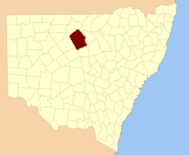
Cowper County
Cowper County, New South Wales is one of the 141 Cadastral divisions of New South Wales.
| Cowper New South Wales | |||||||||||||||
|---|---|---|---|---|---|---|---|---|---|---|---|---|---|---|---|
 Location in New South Wales | |||||||||||||||
| |||||||||||||||
_1886.png)
A map of Cowper County (NSW) in 1886. From John Sands Atlas of Australia.
Cowper County is named in honour of the politician and Premier of New South Wales, Sir Charles Cowper (1807-1875).[1]
It is located to the south-east of Bourke, with the Darling River the boundary to the northwest, and the Bogan River the boundary to the northeast.
The Darling River is the boundary between Cowper and Gunderbooka.
Parishes within this county
A full list of parishes found within this county; their current LGA and mapping coordinates to the approximate centre of each location is as follows:
gollark: Imagine using shell scripts instead of forsaken Python.
gollark: Fascinating.
gollark: > golang
gollark: Obviously the lace person has had [REDACTED] time units and resources to hone their craft.
gollark: Oh, we're discussing *magic-based* ones so it's fine.
References
- "Cowper County". Geographical Names Register (GNR) of NSW. Geographical Names Board of New South Wales.

This article is issued from Wikipedia. The text is licensed under Creative Commons - Attribution - Sharealike. Additional terms may apply for the media files.