Zoteux
Zoteux is a commune in the Pas-de-Calais department in the Hauts-de-France region of France.
Zoteux | |
|---|---|
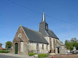
 The church of Zoteux | |
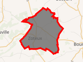
Location of Zoteux 
| |
 Zoteux  Zoteux | |
| Coordinates: 50°36′41″N 1°52′50″E | |
| Country | France |
| Region | Hauts-de-France |
| Department | Pas-de-Calais |
| Arrondissement | Montreuil |
| Canton | Lumbres |
| Intercommunality | Haut Pays du Montreuillois |
| Government | |
| • Mayor (2020-2026) | Daniel Lance |
| Area 1 | 7.34 km2 (2.83 sq mi) |
| Population (2017-01-01)[1] | 615 |
| • Density | 84/km2 (220/sq mi) |
| Demonym(s) | Zotelois, Zoteloises |
| Time zone | UTC+01:00 (CET) |
| • Summer (DST) | UTC+02:00 (CEST) |
| INSEE/Postal code | 62903 /62650 |
| Elevation | 130–172 m (427–564 ft) (avg. 157 m or 515 ft) |
| 1 French Land Register data, which excludes lakes, ponds, glaciers > 1 km2 (0.386 sq mi or 247 acres) and river estuaries. | |
Geography
Zoteux is located 16 miles (26 km) northeast of Montreuil-sur-Mer, on the D343 road.
Population
| Year | Pop. | ±% |
|---|---|---|
| 2006 | 478 | — |
| 2007 | 483 | +1.0% |
| 2008 | 482 | −0.2% |
| 2009 | 501 | +3.9% |
| 2010 | 520 | +3.8% |
| 2011 | 539 | +3.7% |
| 2012 | 558 | +3.5% |
| 2013 | 591 | +5.9% |
| 2014 | 595 | +0.7% |
| 2015 | 598 | +0.5% |
| 2016 | 602 | +0.7% |
| 2017 | 615 | +2.2% |
Politics
Presidential Elections Second Round:[2]
| Election | Winning Candidate | Party | % | |
|---|---|---|---|---|
| 2017 | Marine Le Pen | FN | 54.78 | |
| 2012 | Nicolas Sarkozy | UMP | 56.93 | |
| 2007 | Nicolas Sarkozy | UMP | 59.47 | |
| 2002 | Jacques Chirac | RPR | 82.27 | |
Places of interest
gollark: So actually it's only serialized per connection, or something?
gollark: Technically all accesses are serialized except they actually aren't in WAL mode or if you just have multiple connections.
gollark: I do not know.
gollark: Is the issue that it uses the same connection?
gollark: However, no.
References
- "Populations légales 2017". INSEE. Retrieved 6 January 2020.
- http://www.lemonde.fr/data/france/presidentielle-2017/
| Wikimedia Commons has media related to Zoteux. |
This article is issued from Wikipedia. The text is licensed under Creative Commons - Attribution - Sharealike. Additional terms may apply for the media files.