Montenescourt
Montenescourt is a commune in the Pas-de-Calais department in the Hauts-de-France region of France.
Montenescourt | |
|---|---|
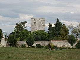 The church of Montenescourt | |
 Coat of arms | |
Location of Montenescourt 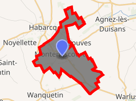
| |
 Montenescourt  Montenescourt | |
| Coordinates: 50°17′36″N 2°37′31″E | |
| Country | France |
| Region | Hauts-de-France |
| Department | Pas-de-Calais |
| Arrondissement | Arras |
| Canton | Avesnes-le-Comte |
| Intercommunality | CC Campagnes de l'Artois |
| Government | |
| • Mayor (2008–2014) | Bernard Libessart |
| Area 1 | 5.08 km2 (1.96 sq mi) |
| Population (2017-01-01)[1] | 460 |
| • Density | 91/km2 (230/sq mi) |
| Time zone | UTC+01:00 (CET) |
| • Summer (DST) | UTC+02:00 (CEST) |
| INSEE/Postal code | 62586 /62123 |
| Elevation | 76–127 m (249–417 ft) (avg. 83 m or 272 ft) |
| 1 French Land Register data, which excludes lakes, ponds, glaciers > 1 km2 (0.386 sq mi or 247 acres) and river estuaries. | |
Geography
Montenescourt is situated 7 miles (11 km) west of Arras, at the junction of the D61 and the D56 roads.
Population
| 1962 | 1968 | 1975 | 1982 | 1990 | 1999 | 2006 |
|---|---|---|---|---|---|---|
| 137 | 153 | 227 | 362 | 418 | 408 | 431 |
| Census count starting from 1962: Population without duplicates | ||||||
Places of interest
- The church of St.Leger, dating from the seventeenth century.
gollark: ↑ you are LEGALLY REQUIRED to react to this
gollark: https://thispersondoesnotexist.com/image
gollark: https://thispersondoesnotexist.com/
gollark: Even if their conclusions are right (doubtful) their reasoning process is seemingly insane.
gollark: Your parents are actually wrong.
References
- "Populations légales 2017". INSEE. Retrieved 6 January 2020.
| Wikimedia Commons has media related to Montenescourt. |
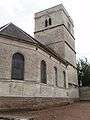 The church
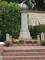 The war memorial
| Authority control |
|
|---|
This article is issued from Wikipedia. The text is licensed under Creative Commons - Attribution - Sharealike. Additional terms may apply for the media files.