Rebreuviette
Rebreuviette is a commune in the Pas-de-Calais department in the Hauts-de-France region of France.
Rebreuviette | |
|---|---|
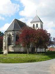 The church of Rebreuviette | |
 Coat of arms | |
Location of Rebreuviette 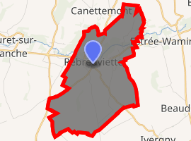
| |
 Rebreuviette  Rebreuviette | |
| Coordinates: 50°15′46″N 2°21′42″E | |
| Country | France |
| Region | Hauts-de-France |
| Department | Pas-de-Calais |
| Arrondissement | Arras |
| Canton | Avesnes-le-Comte |
| Intercommunality | CC Campagnes de l'Artois |
| Government | |
| • Mayor (2008–2014) | Pierrette Duez |
| Area 1 | 8.42 km2 (3.25 sq mi) |
| Population (2017-01-01)[1] | 268 |
| • Density | 32/km2 (82/sq mi) |
| Time zone | UTC+01:00 (CET) |
| • Summer (DST) | UTC+02:00 (CEST) |
| INSEE/Postal code | 62695 /62270 |
| Elevation | 77–150 m (253–492 ft) (avg. 85 m or 279 ft) |
| 1 French Land Register data, which excludes lakes, ponds, glaciers > 1 km2 (0.386 sq mi or 247 acres) and river estuaries. | |
Geography
Rebreuviette lies on the banks of the river Canche, 18 miles (29 km) west of Arras, at the junction of the D53 and D339 roads.
Population
| 1962 | 1968 | 1975 | 1982 | 1990 | 1999 | 2006 |
|---|---|---|---|---|---|---|
| 291 | 298 | 270 | 244 | 248 | 242 | 256 |
| Census count starting from 1962: Population without duplicates | ||||||
Places of interest
- The church of St. Vaast, dating from the sixteenth century.
- An eighteenth-century chapel.
gollark: ↑ LyricLy
gollark: What next, a "current phase of the moon" emoji?
gollark: ÆÆÆÆÆÆÆÆÆÆÆÆÆÆÆÆÆÆÆ DO *NOT* COMPLICATE TEXT RENDERING ÆÆÆÆÆÆÆÆÆÆÆÆÆÆÆÆÆÆÆÆÆÆÆ
gollark: I'm just going to do the list of things with indent depth, would be easier.
gollark: Wrong.
External links
| Wikimedia Commons has media related to Rebreuviette. |
- Rebreuviette on the Quid website (in French)
| Authority control |
|
|---|
This article is issued from Wikipedia. The text is licensed under Creative Commons - Attribution - Sharealike. Additional terms may apply for the media files.