Douchy-lès-Ayette
Douchy-lès-Ayette is a commune in the Pas-de-Calais department in the Hauts-de-France region of France.
Douchy-lès-Ayette | |
|---|---|
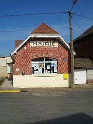 The town hall of Douchy-lès-Ayette | |
 Coat of arms | |
Location of Douchy-lès-Ayette 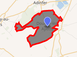
| |
 Douchy-lès-Ayette  Douchy-lès-Ayette | |
| Coordinates: 50°10′37″N 2°43′05″E | |
| Country | France |
| Region | Hauts-de-France |
| Department | Pas-de-Calais |
| Arrondissement | Arras |
| Canton | Bapaume |
| Intercommunality | CC Sud-Artois |
| Government | |
| • Mayor (2008–2014) | Jean-Charles Derue |
| Area 1 | 5.5 km2 (2.1 sq mi) |
| Population (2017-01-01)[1] | 308 |
| • Density | 56/km2 (150/sq mi) |
| Time zone | UTC+01:00 (CET) |
| • Summer (DST) | UTC+02:00 (CEST) |
| INSEE/Postal code | 62272 /62116 |
| Elevation | 92–147 m (302–482 ft) (avg. 106 m or 348 ft) |
| 1 French Land Register data, which excludes lakes, ponds, glaciers > 1 km2 (0.386 sq mi or 247 acres) and river estuaries. | |
Geography
A farming village 9 miles (14.5 km) south of Arras on the D7 road.
Population
| Year | 1962 | 1968 | 1975 | 1982 | 1990 | 1999 |
|---|---|---|---|---|---|---|
| Population | 286 | 309 | 288 | 295 | 321 | 312 |
| From the year 1962 on: No double counting—residents of multiple communes (e.g. students and military personnel) are counted only once. | ||||||
Places of interest
- The church of St.Vaast, rebuilt, as was most of the village, after the destruction wrought by World War I.
- The Commonwealth War Graves Commission cemetery.
gollark: You effectively offload the computing onto the universe's paradox resolution/detection mechanism and/or alternate timelines.
gollark: 1. receive answer from future2. check answer3. send back answer if it's valid4. (depending on time travel model) calculate or randomly generate answer if it's not
gollark: If you have an easy-to-check hard-to-solve problem, some models of time travel let you do it in basically zero time!
gollark: My Discord bot supports messages *to*, but not *from*, the future.
gollark: Trans-temporal messaging *would* be very convenient.
This article is issued from Wikipedia. The text is licensed under Creative Commons - Attribution - Sharealike. Additional terms may apply for the media files.