Outreau
Outreau is a commune in the Pas-de-Calais department in the Hauts-de-France region of France.
Outreau | |
|---|---|
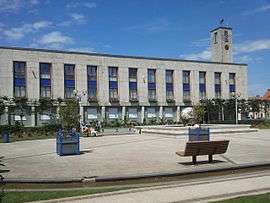
 The town hall of Outreau | |
 Coat of arms | |
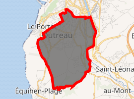
Location of Outreau 
| |
 Outreau  Outreau | |
| Coordinates: 50°42′16″N 1°35′41″E | |
| Country | France |
| Region | Hauts-de-France |
| Department | Pas-de-Calais |
| Arrondissement | Boulogne-sur-Mer |
| Canton | Outreau |
| Intercommunality | Communauté d'agglomération du Boulonnais |
| Government | |
| • Mayor (2008–2014) | Thérèse Guilbert |
| Area 1 | 7.09 km2 (2.74 sq mi) |
| Population (2017-01-01)[1] | 13,422 |
| • Density | 1,900/km2 (4,900/sq mi) |
| Time zone | UTC+01:00 (CET) |
| • Summer (DST) | UTC+02:00 (CEST) |
| INSEE/Postal code | 62643 /62230 |
| Elevation | 2–96 m (6.6–315.0 ft) (avg. 55 m or 180 ft) |
| 1 French Land Register data, which excludes lakes, ponds, glaciers > 1 km2 (0.386 sq mi or 247 acres) and river estuaries. | |
Geography
Outreau is a large industrial town and port situated adjacent to, and west of Boulogne, on the N1, N142 and D19 roads. The river Liane forms the eastern border of the commune with Boulogne.
History
The town suffered greatly from Allied bombing during World War II.
Outreau is notorious throughout France for the Outreau trials of 2001–2004.
Population
| 1962 | 1968 | 1975 | 1982 | 1990 | 1999 | 2006 |
|---|---|---|---|---|---|---|
| 13,548 | 13,735 | 14,731 | 14,590 | 15,279 | 15,222 | 14,650 |
| Census count starting from 1962: Population without duplicates | ||||||
Places of interest
- The church of St. Wandrille, dating from the nineteenth century.
- The sixteenth century manorhouse of La Tour du Renard.
- The Commonwealth War Graves Commission cemetery.
- The war memorial, by Augustin Lesieux.
Geographic location
Twin towns
gollark: Interesting.
gollark: 6MiB per 8192 sentences.
gollark: I had to make my own possibly horribly inefficient search index in GPU memory but it will totally be worth it.
gollark: FEAR Minoteaur semantic search.
gollark: Did you know? Minoteaur semantic search cannot be escaped.
External links
| Wikimedia Commons has media related to Outreau. |
- Official town website (in French)
- Website with photos of Outreau (in French)
- The CWGC cemetery
- Outreau on the Quid website (in French)
- Website of the Communauté d'Agglomération de Boulogne-Côte-d'Opale (in French)
This article is issued from Wikipedia. The text is licensed under Creative Commons - Attribution - Sharealike. Additional terms may apply for the media files.