Loison-sur-Créquoise
Loison-sur-Créquoise is a commune in the Pas-de-Calais department in the Hauts-de-France region of France.
Loison-sur-Créquoise | |
|---|---|
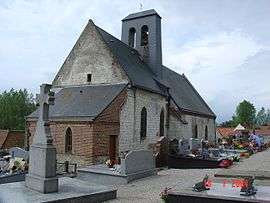 The church of Loison-sur-Créquoise | |
 Coat of arms | |
Location of Loison-sur-Créquoise 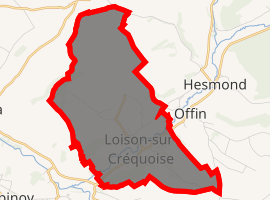
| |
 Loison-sur-Créquoise  Loison-sur-Créquoise | |
| Coordinates: 50°26′24″N 1°55′24″E | |
| Country | France |
| Region | Hauts-de-France |
| Department | Pas-de-Calais |
| Arrondissement | Montreuil |
| Canton | Auxi-le-Château |
| Intercommunality | CC Sept Vallées |
| Government | |
| • Mayor | Pierre Bataille |
| Area 1 | 9.07 km2 (3.50 sq mi) |
| Population (2017-01-01)[1] | 266 |
| • Density | 29/km2 (76/sq mi) |
| Time zone | UTC+01:00 (CET) |
| • Summer (DST) | UTC+02:00 (CEST) |
| INSEE/Postal code | 62522 /62990 |
| Elevation | 12–107 m (39–351 ft) (avg. 33 m or 108 ft) |
| 1 French Land Register data, which excludes lakes, ponds, glaciers > 1 km2 (0.386 sq mi or 247 acres) and river estuaries. | |
Geography
Loison-sur-Créquoise is situated 7 miles (11 km) southeast of Montreuil-sur-Mer on the D130 road and in the Créquoise river valley.
Population
| 1962 | 1968 | 1975 | 1982 | 1990 | 1999 | 2006 |
|---|---|---|---|---|---|---|
| 257 | 269 | 247 | 247 | 268 | 236 | 250 |
| Census count starting from 1962: Population without duplicates | ||||||
Places of interest
- The nineteenth century church of Saint Omer
gollark: Er, no scarcity for any goods.
gollark: What probably will *never* happen is no scarcity for material goods.
gollark: It's probably possible in the relatively near term to have at least freely available food/water/housing. In the longer term, free generic materials (via widespread spaaaaaaaaaace mining and heavy automation).
gollark: See, there's a difference between no material scarcity and no scarcity.
gollark: Er, no.
References
- "Populations légales 2017". INSEE. Retrieved 6 January 2020.
| Wikimedia Commons has media related to Loison-sur-Créquoise. |
| Authority control |
|
|---|
This article is issued from Wikipedia. The text is licensed under Creative Commons - Attribution - Sharealike. Additional terms may apply for the media files.