Ledinghem
Ledinghem (West Flemish: Ledingem) is a commune in the Pas-de-Calais department in the Hauts-de-France region of France.
Ledinghem Ledingem | |
|---|---|
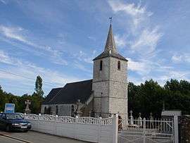 The church of Ledinghem | |
 Coat of arms | |
Location of Ledinghem 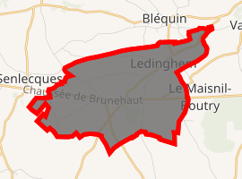
| |
 Ledinghem  Ledinghem | |
| Coordinates: 50°39′15″N 1°59′35″E | |
| Country | France |
| Region | Hauts-de-France |
| Department | Pas-de-Calais |
| Arrondissement | Saint-Omer |
| Canton | Lumbres |
| Intercommunality | Pays de Lumbres |
| Government | |
| • Mayor | Jean Bernard |
| Area 1 | 8.68 km2 (3.35 sq mi) |
| Population (2017-01-01)[1] | 338 |
| • Density | 39/km2 (100/sq mi) |
| Time zone | UTC+01:00 (CET) |
| • Summer (DST) | UTC+02:00 (CEST) |
| INSEE/Postal code | 62495 /62380 |
| Elevation | 100–202 m (328–663 ft) (avg. 122 m or 400 ft) |
| 1 French Land Register data, which excludes lakes, ponds, glaciers > 1 km2 (0.386 sq mi or 247 acres) and river estuaries. | |
Geography
Ledinghem is situated 12 miles (19 km) southwest of Saint-Omer, on the D128 road.
Population
| Year | 1962 | 1968 | 1975 | 1982 | 1990 | 1999 | 2006 |
|---|---|---|---|---|---|---|---|
| Population | 195 | 230 | 227 | 202 | 208 | 207 | 240 |
| From the year 1962 on: No double counting—residents of multiple communes (e.g. students and military personnel) are counted only once. | |||||||
Places of interest
- The church of St. Folquin, dating from the seventeenth century.
- The remains (motte and moat) of an old chateau.
gollark: No, you can do that.
gollark: I wonder why Hydro is selling them. Consolidation? Them doing poorly for some reason? Weird.
gollark: <@115156616256552962> Can I have the traffic lights? I happen to need turtles with deadly lasers for stuff.
gollark: The street signs know where you are at all times. The street signs know what you are doing. The street signs are watching you. The only escape is ~~death~~ the nether because dynmap is weird.
gollark: I heard <@!536016095040110632> was working on their own version, which might be FOSS, so I recommend that people wait a bit for that.
References
- "Populations légales 2017". INSEE. Retrieved 6 January 2020.
| Wikimedia Commons has media related to Ledinghem. |
| Authority control |
|
|---|
This article is issued from Wikipedia. The text is licensed under Creative Commons - Attribution - Sharealike. Additional terms may apply for the media files.