Saint-Hilaire-Cottes
Saint-Hilaire-Cottes is a commune in the Pas-de-Calais department in the Hauts-de-France region of France.
Saint-Hilaire-Cottes | |
|---|---|
The town hall of Saint-Hilaire-Cottes | |
 Coat of arms | |
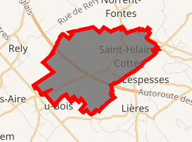
Location of Saint-Hilaire-Cottes 
| |
 Saint-Hilaire-Cottes  Saint-Hilaire-Cottes | |
| Coordinates: 50°34′20″N 2°24′54″E | |
| Country | France |
| Region | Hauts-de-France |
| Department | Pas-de-Calais |
| Arrondissement | Béthune |
| Canton | Aire-sur-la-Lys |
| Intercommunality | CA Béthune-Bruay, Artois-Lys Romane |
| Government | |
| • Mayor (2008–2014) | Philippe Cauwet |
| Area 1 | 7.24 km2 (2.80 sq mi) |
| Population (2017-01-01)[1] | 807 |
| • Density | 110/km2 (290/sq mi) |
| Time zone | UTC+01:00 (CET) |
| • Summer (DST) | UTC+02:00 (CEST) |
| INSEE/Postal code | 62750 /62120 |
| Elevation | 24–102 m (79–335 ft) (avg. 65 m or 213 ft) |
| 1 French Land Register data, which excludes lakes, ponds, glaciers > 1 km2 (0.386 sq mi or 247 acres) and river estuaries. | |
Geography
Saint-Hilaire-Cottes is situated some 10 miles (16.1 km) northwest of Béthune and 37 miles (59.5 km) west of Lille, at the junction of the D943 and D91 roads.
Population
| 1962 | 1968 | 1975 | 1982 | 1990 | 1999 | 2006 |
|---|---|---|---|---|---|---|
| 749 | 753 | 725 | 752 | 750 | 734 | 808 |
| Census count starting from 1962: Population without duplicates | ||||||
Places of interest
- The church of St. Hilaire, dating from the sixteenth century.
- The church of St. Omer, at Cottes, dating from the fifteenth century.
- The Commonwealth War Graves Commission graves.
gollark: Except GTech™ nondestructive neural scanners, you mean. We use them instead of hiring people to save money.
gollark: Perhaps your code is somehow wrong.
gollark: The hard disk I'm using for backups is making faint clicky noises. This is very reassuring.
gollark: Has my backup already finished? This was very fast. I don't trust it.
gollark: Maybe the determinant would have been more funnerer than multiplication. Oh well.
This article is issued from Wikipedia. The text is licensed under Creative Commons - Attribution - Sharealike. Additional terms may apply for the media files.