Saudemont
Saudemont is a commune in the Pas-de-Calais department in the Hauts-de-France region of France.
Saudemont | |
|---|---|
The church of Saudemont | |
 Coat of arms | |
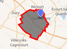
Location of Saudemont 
| |
 Saudemont  Saudemont | |
| Coordinates: 50°14′41″N 3°02′27″E | |
| Country | France |
| Region | Hauts-de-France |
| Department | Pas-de-Calais |
| Arrondissement | Arras |
| Canton | Brebières |
| Intercommunality | CC Osartis Marquion |
| Government | |
| • Mayor (2008–2014) | Jean-Pierre Cuvilliez |
| Area 1 | 5.55 km2 (2.14 sq mi) |
| Population (2017-01-01)[1] | 449 |
| • Density | 81/km2 (210/sq mi) |
| Time zone | UTC+01:00 (CET) |
| • Summer (DST) | UTC+02:00 (CEST) |
| INSEE/Postal code | 62782 /62860 |
| Elevation | 39–75 m (128–246 ft) (avg. 48 m or 157 ft) |
| 1 French Land Register data, which excludes lakes, ponds, glaciers > 1 km2 (0.386 sq mi or 247 acres) and river estuaries. | |
Geography
Saudemont lies 14 miles (22.5 km) southeast of Arras, at the junction of the D39 and D13 roads. The A26 autoroute passes by at a distance of half a mile.
Population
| 1962 | 1968 | 1975 | 1982 | 1990 | 1999 | 2006 |
|---|---|---|---|---|---|---|
| 312 | 315 | 300 | 374 | 382 | 375 | 432 |
| Census count starting in 1962: Population without duplicates | ||||||
Places of interest
- The church of St.Léger, dating from the twelfth century.
gollark: https://projectmanagement.madpronetwork.com/board/1#
gollark: We have a "pixy" camera, which is a camera with some onboard computer vision processing stuff, too.
gollark: It's in the box somewhere I assume.
gollark: Well, three, but two compatible ones.
gollark: There are, however, two (2) cameras.
This article is issued from Wikipedia. The text is licensed under Creative Commons - Attribution - Sharealike. Additional terms may apply for the media files.