Hermaville
Hermaville is a commune in the Pas-de-Calais department in the Hauts-de-France region of France.
Hermaville | |
|---|---|
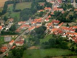 An aerial view of Hermaville | |
 Coat of arms | |
Location of Hermaville 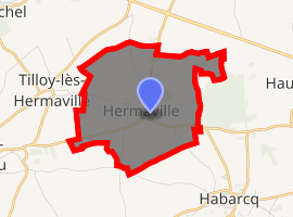
| |
 Hermaville  Hermaville | |
| Coordinates: 50°19′24″N 2°35′14″E | |
| Country | France |
| Region | Hauts-de-France |
| Department | Pas-de-Calais |
| Arrondissement | Arras |
| Canton | Avesnes-le-Comte |
| Intercommunality | CC Campagnes de l'Artois |
| Government | |
| • Mayor (2008–2014) | Michel Accart |
| Area 1 | 6.32 km2 (2.44 sq mi) |
| Population (2017-01-01)[1] | 540 |
| • Density | 85/km2 (220/sq mi) |
| Time zone | UTC+01:00 (CET) |
| • Summer (DST) | UTC+02:00 (CEST) |
| INSEE/Postal code | 62438 /62690 |
| Elevation | 85–142 m (279–466 ft) (avg. 94 m or 308 ft) |
| 1 French Land Register data, which excludes lakes, ponds, glaciers > 1 km2 (0.386 sq mi or 247 acres) and river estuaries. | |
Geography
A farming village situated 8 miles (13 km) west of Arras, at the junction of the D54 and the D74 roads.
Population
| Year | 1962 | 1968 | 1975 | 1982 | 1990 | 1999 | 2006 |
|---|---|---|---|---|---|---|---|
| Population | 315 | 329 | 313 | 402 | 456 | 455 | 536 |
| From the year 1962 on: No double counting—residents of multiple communes (e.g. students and military personnel) are counted only once. | |||||||
Places of interest
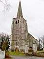
- The church of St. Georges, dating from the seventeenth century.
- The chateau, dating from the eighteenth century.
- Traces of an old castle, destroyed in 1640 by the French.
gollark: Consume additional bees.
gollark: There's a bunch of normalisation stuff and it discards messages of specific lengths. I wouldn't trust its data for anything but limited relative comparison.
gollark: Typing indicators basically.
gollark: It uses algorithms and coding.
gollark: t!speed
External links
| Wikimedia Commons has media related to Hermaville. |
 Saint Georges church in winter
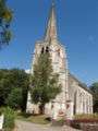 The church in summer
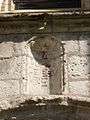 A niche over the church porch
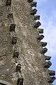 Unusual features on the spire
 The Salignac-Fénelon family crypt
 The farm of Saint Georges
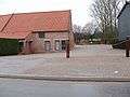 The village hall
| Authority control |
|
|---|
This article is issued from Wikipedia. The text is licensed under Creative Commons - Attribution - Sharealike. Additional terms may apply for the media files.