Ames, Pas-de-Calais
Ames is a commune in the Pas-de-Calais department in the Hauts-de-France region of France.
Ames | |
|---|---|
 The church of Ames | |
 Coat of arms | |
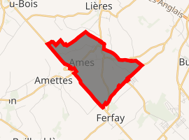
Location of Ames 
| |
 Ames  Ames | |
| Coordinates: 50°32′33″N 2°24′58″E | |
| Country | France |
| Region | Hauts-de-France |
| Department | Pas-de-Calais |
| Arrondissement | Béthune |
| Canton | Lillers |
| Intercommunality | Communauté d'agglomération de Béthune-Bruay, Artois-Lys Romane |
| Government | |
| • Mayor (2014-2020) | Marcel Cocq |
| Area 1 | 3.5 km2 (1.4 sq mi) |
| Population (2017-01-01)[1] | 636 |
| • Density | 180/km2 (470/sq mi) |
| Time zone | UTC+01:00 (CET) |
| • Summer (DST) | UTC+02:00 (CEST) |
| INSEE/Postal code | 62028 /62190 |
| Elevation | 52–99 m (171–325 ft) (avg. 53 m or 174 ft) |
| 1 French Land Register data, which excludes lakes, ponds, glaciers > 1 km2 (0.386 sq mi or 247 acres) and river estuaries. | |
Geography
A farming village situated some 11 miles (17.7 km) west of Béthune and 31 miles (49.9 km) southwest of Lille, at the junction of the D69 and the D91 roads and by the banks of the river Nave.
Population
| Year | Pop. | ±% |
|---|---|---|
| 1962 | 610 | — |
| 1968 | 639 | +4.8% |
| 1975 | 611 | −4.4% |
| 1982 | 601 | −1.6% |
| 1990 | 555 | −7.7% |
| 1999 | 518 | −6.7% |
| 2006 | 563 | +8.7% |
| 2007 | 569 | +1.1% |
| 2009 | 605 | +6.3% |
| 2012 | 653 | +7.9% |
| 2014 | 661 | +1.2% |
| 2015 | 652 | −1.4% |
Sights
- The church of Saint-Pierre, dating from the twelfth century
- The war memorial
gollark: I think GitHub Actions might let you do that automatically at intervals, but I have no idea how.
gollark: Either you can do it in client-side JS, switch hosting, or have a script fetch the thing and output HTML which you could put into the repository.
gollark: Basically, as it's a static site, you can't run any serverside code to fetch and display the feed.
gollark: Ah, so a static website. This might be hard, then.
gollark: <@215706991748841473> What software does your website use?
References
- "Populations légales 2017". INSEE. Retrieved 6 January 2020.
| Wikimedia Commons has media related to Ames (Pas-de-Calais). |
This article is issued from Wikipedia. The text is licensed under Creative Commons - Attribution - Sharealike. Additional terms may apply for the media files.