Lugy
Lugy is a commune in the Pas-de-Calais department in the Hauts-de-France region of France.
Lugy | |
|---|---|
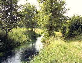 Lys River | |
 Coat of arms | |
Location of Lugy 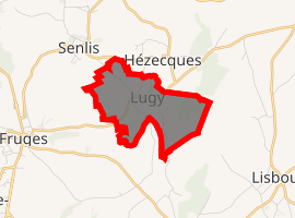
| |
 Lugy  Lugy | |
| Coordinates: 50°31′29″N 2°10′32″E | |
| Country | France |
| Region | Hauts-de-France |
| Department | Pas-de-Calais |
| Arrondissement | Montreuil |
| Canton | Fruges |
| Intercommunality | CC Haut Pays du Montreuillois |
| Government | |
| • Mayor | Philippe Dubreucq |
| Area 1 | 2.83 km2 (1.09 sq mi) |
| Population (2017-01-01)[1] | 147 |
| • Density | 52/km2 (130/sq mi) |
| Time zone | UTC+01:00 (CET) |
| • Summer (DST) | UTC+02:00 (CEST) |
| INSEE/Postal code | 62533 /62310 |
| Elevation | 81–168 m (266–551 ft) (avg. 90 m or 300 ft) |
| 1 French Land Register data, which excludes lakes, ponds, glaciers > 1 km2 (0.386 sq mi or 247 acres) and river estuaries. | |
Geography
Lugy is situated 16 miles (25 km) northeast of Montreuil-sur-Mer on the D130 road.
Population
| 1962 | 1968 | 1975 | 1982 | 1990 | 1999 | 2006 |
|---|---|---|---|---|---|---|
| 128 | 135 | 127 | 96 | 110 | 110 | 139 |
| Census count starting from 1962: Population without duplicates | ||||||
Places of interest
- The eighteenth century church of St.Pierre.
- A restored watermill
gollark: Yes, ish.
gollark: `pommes de terreOS` in france, unrelatedly.
gollark: Anyway, to capture screenshots *at all*, you need to redirect the terminal to a framebuffer of some sort, which is slooooow.
gollark: Basically always.
gollark: CC doesn't have good support, and the framebuffer approach would ruin performance.
External links
| Wikimedia Commons has media related to Lugy. |
- Lugy on the Insee website (in French)
| Authority control |
|
|---|
This article is issued from Wikipedia. The text is licensed under Creative Commons - Attribution - Sharealike. Additional terms may apply for the media files.