Dannes
Dannes is a commune in the Pas-de-Calais department in the Hauts-de-France region of France.
Dannes | |
|---|---|
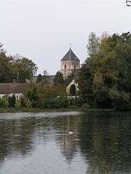 The church of Dannes | |
 Coat of arms | |
Location of Dannes 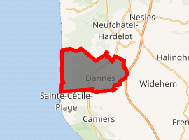
| |
 Dannes  Dannes | |
| Coordinates: 50°35′24″N 1°36′53″E | |
| Country | France |
| Region | Hauts-de-France |
| Department | Pas-de-Calais |
| Arrondissement | Boulogne-sur-Mer |
| Canton | Outreau |
| Intercommunality | Communauté d'agglomération du Boulonnais |
| Government | |
| • Mayor (2008–2014) | Patrice Quételard |
| Area 1 | 10.23 km2 (3.95 sq mi) |
| Population (2017-01-01)[1] | 1,316 |
| • Density | 130/km2 (330/sq mi) |
| Time zone | UTC+01:00 (CET) |
| • Summer (DST) | UTC+02:00 (CEST) |
| INSEE/Postal code | 62264 /62187 |
| Elevation | 4–160 m (13–525 ft) (avg. 30 m or 98 ft) |
| 1 French Land Register data, which excludes lakes, ponds, glaciers > 1 km2 (0.386 sq mi or 247 acres) and river estuaries. | |
Geography
A farming and light industrial village, some 8 miles (13 km) south of Boulogne, at the junction of the D940 and the D148e roads. It is bordered on the western side by the English Channel.
Population
| Year | 1962 | 1968 | 1975 | 1982 | 1990 | 1999 |
|---|---|---|---|---|---|---|
| Population | 1387 | 1391 | 1469 | 1353 | 1301 | 1258 |
| From the year 1962 on: No double counting—residents of multiple communes (e.g. students and military personnel) are counted only once. | ||||||
Places of interest
- The church of St. Martin, dating from the fifteenth century.
gollark: Yes, like all advice I propagate from unfathomable "AI" random inspirational poster generators, it is wondrous.
gollark: https://generated.inspirobot.me/a/wGJgldGDPQ.jpg
gollark: https://generated.inspirobot.me/a/DpPzMLGVJ7.jpg
gollark: It appears that greenology has been taken.
gollark: 503 would be if the server had turned into bees due to too many requests.
References
- "Populations légales 2017". INSEE. Retrieved 6 January 2020.
| Wikimedia Commons has media related to Dannes. |
| Authority control |
|
|---|
This article is issued from Wikipedia. The text is licensed under Creative Commons - Attribution - Sharealike. Additional terms may apply for the media files.