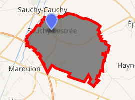
Sauchy-Lestrée
Sauchy-Lestrée is a commune in the Pas-de-Calais department in the Hauts-de-France region of France.
Sauchy-Lestrée | |
|---|---|
The main square of Sauchy-Lestrée | |
 Coat of arms | |
Location of Sauchy-Lestrée 
| |
 Sauchy-Lestrée  Sauchy-Lestrée | |
| Coordinates: 50°13′40″N 3°06′15″E | |
| Country | France |
| Region | Hauts-de-France |
| Department | Pas-de-Calais |
| Arrondissement | Arras |
| Canton | Bapaume |
| Intercommunality | CC Osartis Marquion |
| Government | |
| • Mayor (2008–2014) | Francis Rigaut |
| Area 1 | 9.06 km2 (3.50 sq mi) |
| Population (2017-01-01)[1] | 455 |
| • Density | 50/km2 (130/sq mi) |
| Time zone | UTC+01:00 (CET) |
| • Summer (DST) | UTC+02:00 (CEST) |
| INSEE/Postal code | 62781 /62860 |
| Elevation | 41–77 m (135–253 ft) (avg. 47 m or 154 ft) |
| 1 French Land Register data, which excludes lakes, ponds, glaciers > 1 km2 (0.386 sq mi or 247 acres) and river estuaries. | |
Geography
Sauchy-Lestrée lies 19 miles (30.6 km) southeast of Arras, at the junction of the D21E and D15 roads.
Population
| 1962 | 1968 | 1975 | 1982 | 1990 | 1999 | 2006 |
|---|---|---|---|---|---|---|
| 578 | 588 | 617 | 543 | 458 | 446 | 454 |
| Census count starting in 1962: Population without duplicates | ||||||
Places of interest
- The church of St Ambert, rebuilt, as was much of the village, after World War I.
- The Commonwealth War Graves Commission cemetery.
gollark: You have been greeted.
gollark: I was greeting you.
gollark: Ah, "Totally"Not"Virt"IO.
gollark: Machine learning™, obviously.
gollark: Yes.
External links
| Wikimedia Commons has media related to Sauchy-Lestrée. |
- The CWGC cemetery
- Sauchy-Lestrée on the Quid website (in French)
This article is issued from Wikipedia. The text is licensed under Creative Commons - Attribution - Sharealike. Additional terms may apply for the media files.