Pernes-lès-Boulogne
Pernes-lès-Boulogne is a commune in the Pas-de-Calais department in the Hauts-de-France region of France.
Pernes-lès-Boulogne | |
|---|---|
The church of Pernes-lès-Boulogne | |
 Coat of arms | |
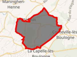
Location of Pernes-lès-Boulogne 
| |
 Pernes-lès-Boulogne  Pernes-lès-Boulogne | |
| Coordinates: 50°45′09″N 1°42′13″E | |
| Country | France |
| Region | Hauts-de-France |
| Department | Pas-de-Calais |
| Arrondissement | Boulogne-sur-Mer |
| Canton | Boulogne-sur-Mer-1 |
| Intercommunality | Communauté d'agglomération du Boulonnais |
| Government | |
| • Mayor (2008–2014) | Jacques Berteloot |
| Area 1 | 7.76 km2 (3.00 sq mi) |
| Population (2017-01-01)[1] | 421 |
| • Density | 54/km2 (140/sq mi) |
| Time zone | UTC+01:00 (CET) |
| • Summer (DST) | UTC+02:00 (CEST) |
| INSEE/Postal code | 62653 /62126 |
| Elevation | 15–109 m (49–358 ft) (avg. 23 m or 75 ft) |
| 1 French Land Register data, which excludes lakes, ponds, glaciers > 1 km2 (0.386 sq mi or 247 acres) and river estuaries. | |
Geography
Pernes-lès-Boulogne is situated 5 miles (8.0 km) northeast of Boulogne, at the junction of the D233 and D233e roads.
Population
| 1962 | 1968 | 1975 | 1982 | 1990 | 1999 | 2006 |
|---|---|---|---|---|---|---|
| 337 | 345 | 331 | 412 | 466 | 423 | 473 |
| Census count starting from 1962: Population without duplicates | ||||||
Places of interest
- The church of St. Esprit, dating from the nineteenth century.
- The three 16th century manorhouses of Senlecque, Godincthun and Huplandre.\
gollark: Says the anarchocommunist who talks about baseball bats constantly?
gollark: And most stuff will just mostly ignore it, so you need to get people to update the stored data somehow.
gollark: Also, you can embed data *in the actual image bit* and it doesn't require any special software/formats - the problem is possible loss during compression.
gollark: Well, malware is hard, see.
gollark: But you could actually embed hidden data in them for... purposes?
References
- "Populations légales 2017". INSEE. Retrieved 6 January 2020.
| Wikimedia Commons has media related to Pernes-lès-Boulogne. |
This article is issued from Wikipedia. The text is licensed under Creative Commons - Attribution - Sharealike. Additional terms may apply for the media files.