Neuvireuil
Neuvireuil is a commune in the Pas-de-Calais department in the Hauts-de-France region of France.
Neuvireuil | |
|---|---|
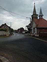 The main road of Neuvireuil | |
 Coat of arms | |
Location of Neuvireuil 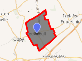
| |
 Neuvireuil  Neuvireuil | |
| Coordinates: 50°21′09″N 2°54′40″E | |
| Country | France |
| Region | Hauts-de-France |
| Department | Pas-de-Calais |
| Arrondissement | Arras |
| Canton | Brebières |
| Intercommunality | CC Osartis Marquion |
| Government | |
| • Mayor (2008–2014) | Jean-Pierre Duval |
| Area 1 | 4.34 km2 (1.68 sq mi) |
| Population (2017-01-01)[1] | 574 |
| • Density | 130/km2 (340/sq mi) |
| Time zone | UTC+01:00 (CET) |
| • Summer (DST) | UTC+02:00 (CEST) |
| INSEE/Postal code | 62612 /62580 |
| Elevation | 40–61 m (131–200 ft) (avg. 55 m or 180 ft) |
| 1 French Land Register data, which excludes lakes, ponds, glaciers > 1 km2 (0.386 sq mi or 247 acres) and river estuaries. | |
Geography
Neuvireuil is situated 7 miles (11 km) northeast of Arras, at the junction of the D46 and D48 roads.
Population
| 1962 | 1968 | 1975 | 1982 | 1990 | 1999 | 2006 |
|---|---|---|---|---|---|---|
| 360 | 362 | 330 | 424 | 474 | 451 | 466 |
| Census count starting from 1962: Population without duplicates | ||||||
Places of interest
- The seventeenth century church of St. Amé, rebuilt after World War I.
gollark: Although I actually haven't had any problems with Nvidia drivers in general, just CUDA randomly not working.
gollark: Audio is easy and just don't nvidia.
gollark: I would really expect it to be using hardware decoding, but I guess for AV1 it can't.
gollark: Maybe your scheduler is wrong.
gollark: (Or worse)
External links
| Wikimedia Commons has media related to Neuvireuil. |
| Authority control |
|
|---|
This article is issued from Wikipedia. The text is licensed under Creative Commons - Attribution - Sharealike. Additional terms may apply for the media files.