Villers-Châtel
Villers-Châtel is a commune in the Pas-de-Calais department in the Hauts-de-France region of France.
Villers-Châtel | |
|---|---|
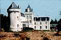
.jpg) The chateau of Villers-Châtel | |
 Coat of arms | |
Location of Villers-Châtel 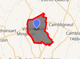
| |
 Villers-Châtel  Villers-Châtel | |
| Coordinates: 50°22′38″N 2°35′17″E | |
| Country | France |
| Region | Hauts-de-France |
| Department | Pas-de-Calais |
| Arrondissement | Arras |
| Canton | Avesnes-le-Comte |
| Intercommunality | CC Campagnes de l'Artois |
| Government | |
| • Mayor (2008–2014) | Maurice Brisset |
| Area 1 | 3.17 km2 (1.22 sq mi) |
| Population (2017-01-01)[1] | 135 |
| • Density | 43/km2 (110/sq mi) |
| Time zone | UTC+01:00 (CET) |
| • Summer (DST) | UTC+02:00 (CEST) |
| INSEE/Postal code | 62857 /62690 |
| Elevation | 111–159 m (364–522 ft) (avg. 147 m or 482 ft) |
| 1 French Land Register data, which excludes lakes, ponds, glaciers > 1 km2 (0.386 sq mi or 247 acres) and river estuaries. | |
Geography
Villers-Châtel is situated some 13 miles (20.9 km) northwest of Arras, at the junction of the D73E road.
Population
| Year | 1962 | 1968 | 1975 | 1982 | 1990 | 1999 | 2006 |
|---|---|---|---|---|---|---|---|
| Population | 83 | 106 | 76 | 92 | 115 | 123 | 122 |
| From the year 1962 on: No double counting—residents of multiple communes (e.g. students and military personnel) are counted only once. | |||||||
Places of interest
- The chateau, dating from the fourteenth century.
gollark: This will remain as the emergency stellated dodecahedron repository.
gollark: I never actually left, I'm just playing both sides, muahahaha.
gollark: <:small_stellated_dodecahedron:800388504756551710>
gollark: Suuuuure.
gollark: I've already migrated ██% of my emoji library here and added bots and APIONET linking!
External links
| Wikimedia Commons has media related to Villers-Châtel. |
- Villers-Châtel on the Quid website (in French)
.jpg)
| Authority control |
|
|---|
This article is issued from Wikipedia. The text is licensed under Creative Commons - Attribution - Sharealike. Additional terms may apply for the media files.