Matringhem
Matringhem is a commune in the Pas-de-Calais department in the Hauts-de-France region of France.
Matringhem | |
|---|---|
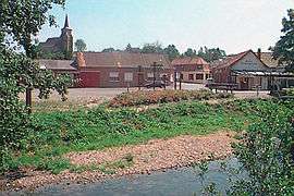 Matringhem with the Lys in the foreground | |
 Coat of arms | |
Location of Matringhem 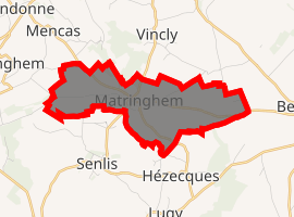
| |
 Matringhem  Matringhem | |
| Coordinates: 50°32′44″N 2°09′57″E | |
| Country | France |
| Region | Hauts-de-France |
| Department | Pas-de-Calais |
| Arrondissement | Montreuil |
| Canton | Fruges |
| Intercommunality | CC Haut Pays du Montreuillois |
| Government | |
| • Mayor | Robert Obin |
| Area 1 | 4.47 km2 (1.73 sq mi) |
| Population (2017-01-01)[1] | 185 |
| • Density | 41/km2 (110/sq mi) |
| Time zone | UTC+01:00 (CET) |
| • Summer (DST) | UTC+02:00 (CEST) |
| INSEE/Postal code | 62562 /62310 |
| Elevation | 75–186 m (246–610 ft) (avg. 89 m or 292 ft) |
| 1 French Land Register data, which excludes lakes, ponds, glaciers > 1 km2 (0.386 sq mi or 247 acres) and river estuaries. | |
Geography
Matringhem is situated in the valley of the Lys river, 20 miles (32 km) northeast of Montreuil-sur-Mer, at the D131 and D104 crossroads.
Population
| 1962 | 1968 | 1975 | 1982 | 1990 | 1999 | 2006 |
|---|---|---|---|---|---|---|
| 197 | 210 | 206 | 204 | 192 | 174 | 178 |
| Census count starting from 1962: Population without duplicates | ||||||
Places of interest
- The church of St.Omer
gollark: I don't actually care that much.
gollark: That was literally ubq's idea some minutes ago.
gollark: It WAS 4/5, apio.
gollark: Done.
gollark: <@!293066066605768714> join then leave it and go consume food
References
- "Populations légales 2017". INSEE. Retrieved 6 January 2020.
| Wikimedia Commons has media related to Matringhem. |
| Authority control |
|
|---|
This article is issued from Wikipedia. The text is licensed under Creative Commons - Attribution - Sharealike. Additional terms may apply for the media files.