Thiembronne
Thiembronne is a commune in the Pas-de-Calais department in the Hauts-de-France region of France.
Thiembronne | |
|---|---|
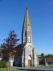 The church of Thiembronne | |
 Coat of arms | |
Location of Thiembronne 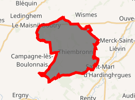
| |
 Thiembronne  Thiembronne | |
| Coordinates: 50°37′16″N 2°03′30″E | |
| Country | France |
| Region | Hauts-de-France |
| Department | Pas-de-Calais |
| Arrondissement | Saint-Omer |
| Canton | Fruges |
| Intercommunality | Pays de Saint-Omer |
| Government | |
| • Mayor | Sylvie Roland |
| Area 1 | 22.82 km2 (8.81 sq mi) |
| Population (2017-01-01)[1] | 834 |
| • Density | 37/km2 (95/sq mi) |
| Time zone | UTC+01:00 (CET) |
| • Summer (DST) | UTC+02:00 (CEST) |
| INSEE/Postal code | 62812 /62560 |
| Elevation | 76–201 m (249–659 ft) (avg. 160 m or 520 ft) |
| 1 French Land Register data, which excludes lakes, ponds, glaciers > 1 km2 (0.386 sq mi or 247 acres) and river estuaries. | |
Geography
Thiembronne is located 15 miles (24 km) southwest of Saint-Omer, on the D158 and D132 road junction.
Population
| 1962 | 1968 | 1975 | 1982 | 1990 | 1999 | 2006 |
|---|---|---|---|---|---|---|
| 661 | 694 | 645 | 621 | 597 | 621 | 697 |
| Census count starting in 1962: Population without duplicates | ||||||
Places of interest
- The church of Saint Pierre, dating from the nineteenth century.
- The nineteenth-century château.
- The remains of the medieval château, destroyed in 1595.
gollark: Also it isn't a cog.
gollark: It's outdated. I COULD `git push` but that would then leak the achievement code.
gollark: Please address all propositions to the osmarks.tk™ propositional processing pipeline.
gollark: What happened to danik?
gollark: Wow, heavserver's inevitability really is inevitable.
References
- "Populations légales 2017". INSEE. Retrieved 6 January 2020.
| Wikimedia Commons has media related to Thiembronne. |
| Authority control |
|
|---|
This article is issued from Wikipedia. The text is licensed under Creative Commons - Attribution - Sharealike. Additional terms may apply for the media files.