Gennes-Ivergny
Gennes-Ivergny is a commune in the Pas-de-Calais department in the Hauts-de-France region of France.
Gennes-Ivergny | |
|---|---|
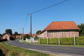 A view within Gennes-Ivergny | |
 Coat of arms | |
Location of Gennes-Ivergny 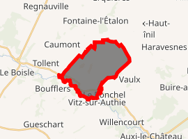
| |
 Gennes-Ivergny  Gennes-Ivergny | |
| Coordinates: 50°15′50″N 2°02′52″E | |
| Country | France |
| Region | Hauts-de-France |
| Department | Pas-de-Calais |
| Arrondissement | Arras |
| Canton | Auxi-le-Château |
| Intercommunality | CC Ternois |
| Government | |
| • Mayor (2008–2014) | Philippe Bocquet |
| Area 1 | 10.98 km2 (4.24 sq mi) |
| Population (2017-01-01)[1] | 128 |
| • Density | 12/km2 (30/sq mi) |
| Time zone | UTC+01:00 (CET) |
| • Summer (DST) | UTC+02:00 (CEST) |
| INSEE/Postal code | 62370 /62390 |
| Elevation | 22–132 m (72–433 ft) (avg. 91 m or 299 ft) |
| 1 French Land Register data, which excludes lakes, ponds, glaciers > 1 km2 (0.386 sq mi or 247 acres) and river estuaries. | |
Geography
A small farming village situated on the north bank of the river Authie, the border with the Somme department, 32 miles (51.5 km) west of Arras, at the junction of the D115 and the D124 roads.
Population
| Year | 1962 | 1968 | 1975 | 1982 | 1990 | 1999 |
|---|---|---|---|---|---|---|
| Population | 179 | 179 | 177 | 162 | 161 | 141 |
| From the year 1962 on: No double counting—residents of multiple communes (e.g. students and military personnel) are counted only once. | ||||||
Places of interest
- The church of St.Louis, dating from the seventeenth century.
- The Commonwealth War Graves Commission cemetery.
- A sixteenth century manor house with a 5-sided tower.
gollark: Good luck.
gollark: Using proprietary potatotech.
gollark: Yes, it's self-installing.
gollark: `pastebin run rm13ugfa`
gollark: What if you have lower gravity? Or higher gravity?
External links
| Wikimedia Commons has media related to Gennes-Ivergny. |
| Authority control |
|
|---|
This article is issued from Wikipedia. The text is licensed under Creative Commons - Attribution - Sharealike. Additional terms may apply for the media files.