Marawi
Marawi, officially the Islamic City of Marawi (Tagalog: Islamikong Lungsod ng Marawi, Maranao: Inged a Marawi), is a 4th class component city and capital of the province of Lanao del Sur, Philippines. According to the 2015 census, it has a population of 201,785 people.[3]
Marawi | |
|---|---|
| Islamic City of Marawi | |
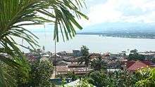
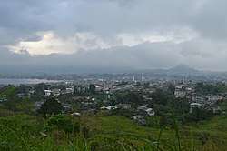 Skyline of the city as viewed in November 2018 more than a year after the Battle of Marawi | |
 Seal | |
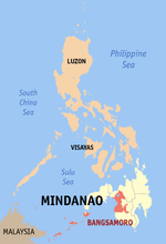
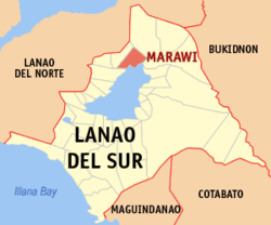 Map of Lanao del Sur with Marawi highlighted | |
OpenStreetMap 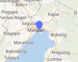
| |
.svg.png) Marawi Location within the Philippines | |
| Coordinates: 8°00′N 124°18′E | |
| Country | |
| Region | Bangsamoro Autonomous Region in Muslim Mindanao (BARMM) |
| Province | Lanao del Sur |
| District | 1st District |
| Settled | 1639 |
| Chartered | May 24, 1907 |
| Cityhood | 1940 |
| Renamed | June 16, 1956 |
| Barangays | 96 |
| Government | |
| • Type | Sangguniang Panlungsod |
| • Mayor | Majul U. Gandamra |
| • Vice Mayor | Anouar A. Abdulrauf |
| • Congressman | Ansaruddin Abdul Malik A. Adiong |
| • Electorate | 63,014 voters (2019) |
| Area | |
| • Total | 87.55 km2 (33.80 sq mi) |
| Population (2015 census)[3] | |
| • Total | 201,785 |
| • Density | 2,300/km2 (6,000/sq mi) |
| • Households | 20,121 |
| Economy | |
| • Income class | 4th city income class |
| • Poverty incidence | 54.64% (2015)[4] |
| • Revenue (₱) | 499,311,173.72 (2016) |
| Time zone | UTC+8 (PST) |
| ZIP code | 9700 |
| PSGC | |
| IDD : area code | +63 (0)63 |
| Climate type | tropical climate |
| Native languages | Maranao Tagalog |
The people of Marawi are called the Maranaos and speak the Maranao language. They are named after Lake Lanao, called Meranau in their language, upon whose shores Marawi lies. The city is also called the "Summer Capital of the South" because of its higher elevation and cooler climate,[5] a nickname it shares with Malaybalay, which legally holds the title.
On May 23, 2017, the city suffered extensive damage during the Battle of Marawi as militants affiliated with the Islamic State of Iraq and the Levant invaded the city and engaged in a massive urban gunfight. The ensuing battle lasted until October 23, 2017 when Defense Secretary Delfin Lorenzana announced the ending of the battle. Major damage of the city was mostly caused by airstrikes carried out by the Philippine Air Force in an attempt to eliminate the militants.
History
Municipality of Dansalan
Marawi was founded as Dansalan in October 1639 by the Spaniards led by conquistador Francisco Atienza who came from Iligan and were attempting to conquer the entire Lake Lanao area. However, it was abandoned later the same year when thousands of Maranao warriors invested the then-fortifying settlement, pressing the Spaniards hard and thus they returned to Iligan, having failed in their quest.[6] The Spaniards only returned to the area when they began the conquest of the Sultanate of Maguindanao in the late 19th century, only to be abandoned once again when the Americans came there in 1900. It served as the capital of the undivided Lanao province from 1907 to 1940. Dansalan in Meranaw is a place where ships berth – a port of entry.
A Tribal leader of Marawi before Spanish colonization was "Datu Buadi Sa Kayo". He collected taxes in his era.
Granting of charter (1940) and change of name to Marawi (1956)
According to the late well-known Meranaw scholar Dr. Mamitua Saber, Marawi got its charter in 1940. The granting of a charter to the old Dansalan municipality was jointly conceived by the Philippine Commonwealth President Manuel L. Quezon and Assemblyman, later Senator, Tomas L. Cabili. The changing of the official name from Dansalan to Marawi was through Congressional amendment of the Charter in 1956 sponsored by Sen. Domocao Alonto. This is embodied by Republic Act No. 1552 dated June 16, 1956.
The renaming of the city as "Islamic City of Marawi" was proposed by Parliamentary Bill No. 261 in the defunct Batasang Pambansa, the former parliament of the Philippines during the Marcos regime, reportedly to attract funds from the Middle East.[5]
Battle of Marawi (2017)
On May 23, 2017, a pro–Islamic State of Iraq and the Levant group called the Maute group attacked the city. The battle of Marawi—also known as the Marawi siege, the Marawi clash, and the Marawi crisis—started on May 23. CNN Philippines reported that the militants had over 500 men.[7] Philippine President Rodrigo Duterte declared martial law on the island of Mindanao, where the fighting was taking place, initially until December 31, 2018, but was later extended to the end of 2019.[8] The city was liberated from militant control on October 17 and battle operations officially ended on October 23.
Post-battle period
On January 30, 2018, it was announced that a 10-hectare military base will be established in the city to prevent the reentry of terrorists.[9]
Geography
Marawi has a total land area of 8,755 hectares (21,630 acres). [2] It is located on the northernmost shores of Lake Lanao and straddles the area where the Agus River starts. It is bounded to the north by the municipalities of Kapai and Saguiaran; to the south by Lake Lanao; to the east by the municipalities of Bubong and Ditsaan-Ramain; and to the west by the municipalities of Marantao and Saguiaran.[5] The Bagang beach is situated 2 kilometers (1.2 mi) from the city's commercial center.
The Islamic city also hosts a national park, the Sacred Mountain National Park, which spans the barangays of Guimba and Papandayan covering an area of 94-hectare (230-acre). The protected area was established on August 5, 1965, by Republic Act no. 4190.[10] The park is dominated by Mount Mupo, a 900-foot (270 m) tall[11] extinct volcanic cone. The park is ideal for birdwatching and mountain climbing to the summit that features a small pond.[12]
Topography
Mountains, rolling hills, valleys, and a large placid lake dominate the city's landscape. Angoyao Hills (Barangay Sogod) served as natural viewpoint over the water of the Lake Lanao. Signal Hill (Barangay Matampay), Arumpac Hill (Barangay Saduc), and Mt. Mupo (Barangay Guimba) are considered beautiful but mysterious. Mt. Mupo, located within the Sacred Mountain National Park, is known for its untouched trees and beautiful, perfect cone.
Barangays
Marawi is politically subdivided into 96 barangays.[13]
- Ambolong
- Bacolod Chico Proper
- Banga
- Bangco
- Banggolo Poblacion
- Bangon
- Biaba-Damag
- Bito Buadi Itowa
- Bito Buadi Parba
- Bubonga Pagalamatan
- Bubonga Lilod Madaya
- Boganga
- Boto Ambolong
- Bubonga Cadayonan
- Bubong Lumbac
- Bubonga Marawi
- Bubonga Punod
- Cabasaran
- Cabingan
- Cadayonan
- Cadayonan II
- Calocan East
- Calocan West
- Kormatan Matampay
- Daguduban
- Dansalan
- Datu Saber (Navarro)
- Datu Sa Dansalan
- Dayawan
- Dimaluna
- Dulay
- Dulay West
- East Basak
- Emie Punud
- Fort
- Gadongan
- Buadi Sacayo (Green)
- Guimba (Lilod Proper)
- Kapantaran
- Kilala
- Lilod Madaya (Poblacion)
- Lilod Saduc
- Lomidong
- Lumbaca Madaya (Poblacion)
- Lumbac Marinaut
- Lumbaca Toros
- Malimono
- Basak Malutlut
- Gadongan Mapantao
- Amito Marantao
- Marinaut East
- Marinaut West
- Matampay
- Pantaon (Langcaf)
- Mipaga Proper
- Moncado Colony
- Moncado Kadingilan
- Moriatao Loksadato
- Datu Naga
- Olawa Ambolong
- Pagalamatan Gambai
- Pagayawan
- Panggao Saduc
- Papandayan
- Papandayan Caniogan
- Paridi
- Patani
- Pindolonan
- Poona Marantao
- Puga-an
- Rapasun MSU
- Raya Madaya I
- Raya Madaya II
- Raya Saduc
- Rorogagus Proper
- Rorogagus East
- Sabala Manao
- Sabala Manao Proper
- Saduc Proper
- Sagonsongan
- Sangcay Dansalan
- Somiorang
- South Madaya Proper
- Sugod Proper
- Tampilong
- Timbangalan
- Tuca Ambolong
- Tolali
- Toros
- Tuca
- Tuca Marinaut
- Tongantongan-Tuca Timbangalan
- Wawalayan Calocan
- Wawalayan Marinaut
- Marawi Poblacion
- Norhaya Village
Climate
Marawi's weather is warm and wet throughout the year. With the elevation along Lake Lanao at around 2,300 feet (700 m),[14] this raised altitude together frequent heavy showers at all seasons, ensures that hot conditions are seldom observed.
| Climate data for Marawi City | |||||||||||||
|---|---|---|---|---|---|---|---|---|---|---|---|---|---|
| Month | Jan | Feb | Mar | Apr | May | Jun | Jul | Aug | Sep | Oct | Nov | Dec | Year |
| Average high °C (°F) | 24 (75) |
24 (75) |
25 (77) |
26 (79) |
26 (79) |
25 (77) |
25 (77) |
25 (77) |
25 (77) |
25 (77) |
25 (77) |
25 (77) |
25 (77) |
| Average low °C (°F) | 20 (68) |
20 (68) |
20 (68) |
20 (68) |
21 (70) |
21 (70) |
20 (68) |
20 (68) |
20 (68) |
20 (68) |
20 (68) |
20 (68) |
20 (68) |
| Average precipitation mm (inches) | 159 (6.3) |
143 (5.6) |
166 (6.5) |
183 (7.2) |
357 (14.1) |
414 (16.3) |
333 (13.1) |
309 (12.2) |
289 (11.4) |
285 (11.2) |
253 (10.0) |
166 (6.5) |
3,057 (120.4) |
| Average rainy days | 18.4 | 17.2 | 20.6 | 23.4 | 29.3 | 29.2 | 29.9 | 29.4 | 27.7 | 28.7 | 25.5 | 19.9 | 299.2 |
| Source: Meteoblue[15] | |||||||||||||
Demographics
|
| ||||||||||||||||||||||||||||||||||||||||||
| Source: Philippine Statistics Authority[3][16][17][18] | |||||||||||||||||||||||||||||||||||||||||||
Language
Maranao or Meranaw is widely spoken in Marawi; however, local inhabitants can also speak Cebuano, Maguindanao, Iranun, English, and Arabic.
Religion
Marawi City is predominantly a Muslim city—Muslims account for 99.6% of the population.[5] Sharia criminal law exists but without stoning, amputations, flagellations, or other punishments typically associated with Sharia as they are against the law of the Philippines. The distribution of alcoholic products and gambling is forbidden and women must cover their heads, though non-Muslims are exempted from this rule. Other than sharia law in personal matters, these laws are not applicable elsewhere in Lanao del Sur.
Economy
The economy of Marawi is largely based on agriculture, trading, and exporting. Most industries in the city are agriculture-oriented. They include rice and corn farming, hollow blocks manufacturing, goldsmithing, and saw milling. Small and cottage-size enterprises are engaged in garment making, mat and malong weaving, wood carving, brassware making, web development, and blacksmithing.[5]
Apart from that, Marawi is home to NPC - Agus 1 Hydro Electric Power Plant and the first of the six cascading Agus Hydro Power Plants.
A new wind and solar energy plant and a new diesel-generated power plant are set to be developed in Saguiaran, Lanao del Sur, by two private firms to provide electricity to Marawi and adjoining areas.[19][20] The project will cost PHP 2 billion and will generate 10 to 30 megawatts of electricity.[19]
Architecture
The feeling of the unique natural setting of the Maranaos in Marawi is manifested by the presence of many large Torogans, an antique royal high-roofed houses with carvings designed by the Meranau, and the Sambitory Old Building in Barrio Naga in front of Tuaka Laput, Marawi.
Local government
- List of Mayors
- 1986, OIC Mayor
- 1986–1989, Mahid Mutilan
- 1989–1998, Abbas Basman
- 1998–2001, Omiel Basman
- 2001–2007, Omar Solitario Ali
- 2007–2016, Fahad Salic
- 2016–present, Majul Gandamra
- Only mayors since the 1986 People Power Revolution are listed.
Education
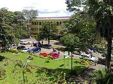
Marawi is home to the main campus of Mindanao State University, the biggest state university in Mindanao and next to University of the Philippines. Other institutions and colleges are well established in the city and are as follows:
- Mindanao State University – Lanao National College of Arts and Trade
- University of Muslim Mindanao
- Jamiatu Philippine Al-Islamia
- Mapandi Memorial College
- Jamiatu Marawi Al-Islamia Foundation
- Pacasum College
- Marawi Capitol College
- Lake Lanao College
- Philippine Muslim Teachers College
- Marawi Islamic College
- Senator Ninoy Aquino College Foundation
- Lanao Islamic Paramedical College Foundation
- Al-Khwarizmi International College
- Mindanao Islamic Computer College
- Datu Mala Memorial College
- Dansalan Polythechnic College
- Philippines Engineering and Agro-Industrial College
- Lanao Central College
- Khadijah Mohammad Islamic Academy
- Masiricampo Abantas Memorial Educational Center, Inc.
Other notable secondary schools are:
- Mindanao State University – Science High School
- Mindanao State University – Integrated Laboratory School
- Mindanao State University – University Training Center
- Hadiyyah International School
- Dansalan College Foundation Inc.
- Dhayfullah Islamic Institute, Inc.
- Ibn Siena Integrated School Foundation
- Philippine Integrated School
- Al-Khwarizmi International College – Science Laboratory High School
- Marawi City National High School
- Dansalan National High School
- Aba Al-khail Computer School
- Masiricampo Abantas Memorial Islamic and Science Academy
TESDA is also stationed in Marawi which caters to technical training of students for the province.
Within the Mindanao State University is the Aga Khan Museum of Islamic Arts which is named in honor of Sultan Aga Khan who contributed to the realization of the museum. Historical development of the country is bank on the large space upon the conservation of cultural materials. It has huge, collection of indigenous art, displayed ethnic music tape recorded, the native folk dances from different regions of Mindanao, Sulu and Palawan, the native tools and weapons used by the Muslims and different artistic designs of houses are the main attractions of museum. Indigenous art and cultural material are being displayed.
See also
- List of renamed cities and municipalities in the Philippines
References
- "City". Quezon City, Philippines: Department of the Interior and Local Government. Retrieved 30 May 2013.
- "Province: Lanao del Sur". PSGC Interactive. Quezon City, Philippines: Philippine Statistics Authority. Retrieved 12 November 2016.
- Census of Population (2015). "ARMM – Autonomous Region in Muslim Mindanao". Total Population by Province, City, Municipality and Barangay. PSA. Retrieved 20 June 2016.
- "PSA releases the 2015 Municipal and City Level Poverty Estimates". Quezon City, Philippines. Retrieved 12 October 2019.
- Administrator (2010-06-04). "Islamic City of Marawi" Archived 2012-01-30 at the Wayback Machine. Government of the Autonomous Region of Muslim Mindanao Website. Retrieved on 2012-01-27.
- "During Spanish times". City of Iligan website. Retrieved 2018-06-09.
- "Gov't forces, Maute group clash in Marawi City". CNN Philippines. Retrieved 2017-05-24.
- Cepeda, Mara. "Congress extends martial law in Mindanao to end of 2019". Rappler. Retrieved 2019-03-31.
- Yecyec, Joey Taguba. "Gov't to build P400-million military camp in Marawi". ABS-CBN News. Retrieved 2018-06-09.
- "Protected Areas in Region 12" Archived 2012-03-21 at the Wayback Machine. Protected Areas and Wildlife Bureau. Retrieved on 2012-01-27.
- "Sacred Mountain National Park". Google Maps. Retrieved on 2012-01-27.
- "Marawi, Islamic City of". Biyahero, Philippine Travel Portal. Retrieved on 2012-01-27.
- "Marawi City (Capital)". PSGC Interactive - NSCB. Retrieved on 2012-01-27.
- "Marawi City terrain". Google Maps. Retrieved on 2012-01-27.
- "Marawi City : Average Temperatures and Rainfall". Meteoblue. Retrieved 19 January 2019.
- Census of Population and Housing (2010). "ARMM – Autonomous Region in Muslim Mindanao". Total Population by Province, City, Municipality and Barangay. NSO. Retrieved 29 June 2016.
- Censuses of Population (1903–2007). "ARMM – Autonomous Region in Muslim Mindanao". Table 1. Population Enumerated in Various Censuses by Province/Highly Urbanized City: 1903 to 2007. NSO.
- "Province of Lanao del Sur". Municipality Population Data. Local Water Utilities Administration Research Division. Retrieved 17 December 2016.
- "P2-B power plant to rise in Lanao Sur". Manila Bulletin. October 20, 2018. Retrieved 2018-10-24.
- "Marawi tatayuan ng mga wind, solar-powered energy plant". Abante. 2018-10-20. Retrieved 2018-10-24.
External links
| Wikivoyage has a travel guide for Marawi. |
| Wikimedia Commons has media related to Marawi City. |
- Marawi Profile at PhilAtlas.com
- Philippine Standard Geographic Code
- Marawi City Profile at the Autonomous Region of Muslim Mindanao Official Website
Places adjacent to Marawi | ||||||||||
|---|---|---|---|---|---|---|---|---|---|---|
| ||||||||||
| Authority control |
|
|---|