Leyte (province)
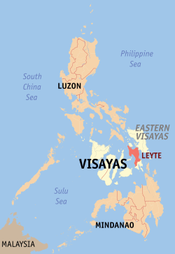
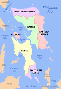
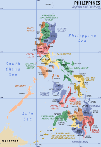
Leyte (also Northern Leyte; Cebuano: Amihanang Leyte; Waray: Norte san/Amihanan nga Leyte) is a province in the Philippines located in the Eastern Visayas region, occupying the northern three-quarters of Leyte Island. Its capital is the city of Tacloban. Leyte is situated west of Samar Island, north of Southern Leyte and south of Biliran. To the west of Leyte across the Camotes Sea is the province of Cebu.
Leyte | |
|---|---|
| Province of Leyte | |
 | |
 Flag  Seal | |
 Location in the Philippines | |
| Coordinates: 11°00′N 124°51′E | |
| Country | Philippines |
| Region | Eastern Visayas (Region VIII) |
| Founded | 1735[1] |
| Capital | Tacloban |
| Government | |
| • Governor | Leopoldo Dominico Petilla (PDP-LABAN) |
| • Vice Governor | Carlo Loreto (LP) |
| • Congressional Representative | Congressmen
|
| Area | |
| • Total | 6,313.33 km2 (2,437.59 sq mi) |
| Area rank | 13th out of 81 |
| (excludes Tacloban City) | |
| Highest elevation (Alto Peak) | 1,348 m (4,423 ft) |
| Population (2015 census)[3] | |
| • Total | 1,724,679 |
| • Rank | 14th out of 81 |
| • Density | 270/km2 (710/sq mi) |
| • Density rank | 34th out of 81 |
| (excludes Tacloban City) | |
| Demonym(s) | Leytehanon Leyteño (Spanish) |
| Divisions | |
| • Independent cities | |
| • Component cities | 1
|
| • Municipalities | 40
|
| • Barangays |
|
| • Districts | 1st to 6th districts of Leyte (shared with Ormoc and Tacloban cities) |
| Time zone | UTC+8 (PST) |
| ZIP Code | 6500–6542 |
| IDD : area code | +63 (0)53 |
| ISO 3166 code | PH-LEY |
| Spoken languages | |
| Website | www |
The historical name of the Philippines, "Las Islas Felipenas", named by Spanish explorer Ruy López de Villalobos in honor of Prince Philip of Spain, used to refer to the islands of Leyte and Samar only, until it was adopted to refer to the entire archipelago.[4]
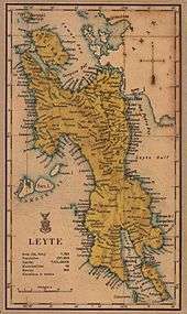
The island of Leyte is known as Tandaya during the 16th century.[5]
Leyte is also known as the site of the largest naval battle in modern history, the Battle of Leyte Gulf, which took place during the Second World War.
Leyte is especially prone to typhoons because it geographically faces toward the Pacific Ocean. On 8 November 2013, the province was severely affected by Super Typhoon Yolanda (Haiyan). The typhoon, known internationally as Haiyan, and domestically referred to as Yolanda, killed thousands of people and garnered significant international media attention. Leyte suffered similar destruction and loss of life in 1991 from Tropical Storm Thelma.
History
Pre-colonial period
The island of Leyte was once the location of Mairete, meaning land of Ete, a historic community which was ruled by Datu Ete centered in present-day Tacloban and nearby towns. It was the oldest city-state in the entire Eastern Visayas region. Before being colonized by Spain, the island was once home to indigenous animist Warays to the East and other indigenous Hindu-Buddhist Visayan groups to the west.
Spanish period
The Spanish explorer Ruy López de Villalobos, first came to the island in 1543 and named it Las Islas Felipinas. When the Spanish government established government in Cebu, Leyte and Samar became part of the province of Cebu. In 1595, the religious Jesuits established mission in Carigara which preceded the mission established in Palo in 1596 and Ormoc and Alangalang missions in 1597. In 1735, Leyte and Samar were separated from Cebu to be established as a single provincial government with Carigara as the first provincial capital. In 1768, Leyte and Samar were split into two separate provinces.
American period
Division of Leyte
On March 27, 1923, Act No 3117 was proposed to divide Leyte into Occidental Leyte and Oriental Leyte but was not proclaimed by the Governor-General of the Philippines. On May 22, 1959, Republic Act No. 2227 was passed into law that separated the third Congressional District of Leyte into a separate province of Southern Leyte.[6]
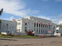
During the World War II era, the Leyte Provincial Capitol briefly became the seat of Philippine Commonwealth Government.
Battle of Leyte Gulf
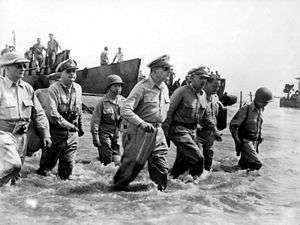
The Battle of Leyte Gulf took place in the seas surrounding this island from 23 October to 26 October 1944. It was the largest naval battle in modern history, when at least 212 Allied ships clashed with the remnants of the Imperial Japanese Navy, some 60 ships, including the super battleships Yamato and Musashi.
The First Battle of Leyte occurred on 20 October 1944. A successful Allied invasion of the island was the crucial element to the eventual Filipino and American victory in the Philippines.
Geography
Leyte covers a total area of 6,313.33 square kilometres (2,437.59 sq mi)[7] occupying the northern and central sections of Leyte in the Eastern Visayas region. The province is situated west of Samar Island, north of Southern Leyte, south of Biliran, and east of the Camotes Sea.
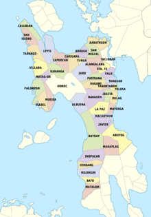
Administrative divisions
Leyte comprises 40 municipalities and three cities, all clustered into 5 congressional districts.
Ormoc City is an independent component city, while the capital Tacloban was declared a highly urbanized city in 2008. Both cities govern themselves independently of the province and their residents do not vote for elective provincial officials.
Baybay attained cityhood in 2007 but reverted to its municipal status when the Supreme Court declared its city charter unconstitutional in 2008. It regained its city status following the reversal of the Supreme Court decision dated December 22, 2009.[8] In August 2010, however, a resolution had been passed reverting 16 cities, one of which was Baybay, to municipal status. It was on February 15, 2011 that the Supreme Court reversed its decision once again, allowing Baybay, along with the other 16 cities, to retain their cityhood status.
- † Provincial capital and highly urbanized city
- ^ Independent component city
- ∗ Component city
- Municipality
| ||||||||||||||||||||||||||||||||||||||||||||||||||||||||||||||||||||||||||||||||||||||||||||||||||||||||||||||||||||||||||||||||||||||||||||||||||||||||||||||||||||||||||||||||||||||||||||||||||||||||||||||||||||||||||||||||||||||||||||||||||||||||||||||||||||||||||||||||||||||||||||||||||||||||||||||||||||||||||||||||||||||||||||||||||||||||||||||||||||||||||||||||||||||||||||||||||||||||||||||||||||||||||||||||||||||||||||||||||||||||||||||||||||||||||||||||||||||||||||||||||||||||||||||||||||||||||||||||||||||||||||||||||||||||||||||||||||||||||||||||||||||||||||||||||||||||||||||||||||||||||||
Demographics
| Year | Pop. | ±% p.a. |
|---|---|---|
| 1990 | 1,230,925 | — |
| 1995 | 1,343,941 | +1.66% |
| 2000 | 1,413,697 | +1.09% |
| 2007 | 1,506,096 | +0.88% |
| 2010 | 1,567,984 | +1.48% |
| 2015 | 1,724,679 | +1.83% |
| (excluding Tacloban City) Source: Philippine Statistics Authority[3][9][9] | ||
The population of Leyte in the 2015 census was 1,724,679 people,[3] with a density of 270 inhabitants per square kilometre or 700 inhabitants per square mile. When Tacloban City is included for geographical purposes, the population is 1,966,768 people, with a density of 302/km2 (782/sq mi).
The people of Leyte are divided into two main groups, primarily by language. In the west and south are the Cebuanos, while in the north and east are the Warays.
There are also some Spanish mestizos and some natives of the province who can understand and speak Spanish due to the province's colonial history. Most Leyteños also can also speak and understand English.
Leyte is predominantly Roman Catholic Christian province. According to the Year 2000 census, 97% of Leyte's population is Roman Catholic Christians, one of the highest percentage in the Visayas. While the remaining 3% are adherents of other different Christian sects, denominations and churches such as the indigenous Iglesia ni Cristo, Kingdom of Jesus Christ and Members Church of God International or popularly known as Ang Dating Daan and the foreign religious groups like Mormons, Baptists, Evangelicals, Pentecostals, and Seventh-Day Adventists (Sabadistas) and other Protestant groups.
Islam is also present in the province and concentrated in the metropolitan Tacloban area. It comprised 0.3% of Tacloban City's population and all adherents are Maranao and other Moro migrants from the Mindanao region who work mostly as traders.
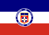
Official provincial seal
The upper portion is a perspective of the national Freedom Park commemorating the landing of General Douglas MacArthur and the American Liberation Forces in Leyte during World War II. The white cross represents the 2nd phase of Leyte's development when Magellan stopped here on his way to Cebu. The alphabet on the cross argent is the ancient Visayan paleographic syllabary of the letter L which stands for Leyte. The stars around the inner circle symbolize the forty-one (41) towns of Leyte and the everlasting flame symbolizes the soldiers who died during World War II.
Economy
The economy of Leyte is a mixed agriculture, fishing, industrial, energy and mining. Rice is farmed in the lowland plains areas specifically those around Tacloban, while coconut farming, is the main cash crop in upland and mountainous areas. Sugarcane plantation is no. 1 produce in Ormoc City. Since Leyte is an island province, fishing is a major source of livelihood among coastal residents.
The province is the site of the largest geothermal plant in Asia, making it one of the resource-rich provinces of the Philippines. Excess energy of the numerous powerplants in the geothermal valley that generate electricity is supplied to the national grid that adds to the energy demand in Luzon and Mindanao. Mining industry has started to pick up in the province with the exploration in MacArthur. The iron smelting in Isabel has been operational for more than 20 years since its inception.
Leyte ICT Park
The Leyte Information Communications Technology (ICT) Park is one of the economic zones approved by the Philippine Economic Zone Authority (PEZA).[10] Located at Pawing, Palo, Leyte, the 6.8 facility hosts two (2) business process outsourcing (BPO) companies, namely, the Expert Global Solutions (EGS) Company (formerly APAC Customer Services, Inc.) and ACUDATA, Inc. (a financial and data services BPO). However, EGS decided to fully close its operations after its facility was destroyed by Typhoon Haiyan in 2013.
Leyte is emerging to be an ICT-BPO Hub for Eastern Visayas.
Transportation
Leyte is connected by air with its only commercial airport located in Tacloban City. Daniel Z. Romualdez Airport, which is one of the busiest airports in the Philippines, is served by three major airlines, Philippine Airlines, Cebu Pacific and AirAsia. Tacloban Airport primarily serves connecting flights from major Philippine cities (Manila and Cebu).
Philtranco, which has a bus stop in Tacloban and Ormoc, operates a route along Manila-Maharlika highway, passing through Allen, Northern Samar in Samar Island (via ferry boat) from Matnog, Sorsogon in Bicol region.
Commercial seaport is of vital importance. Major ports of the province are located at Ormoc City,in the south and Tacloban City, in the north. Small ports are also located in Palompon, San Isidro, Bato, Hilongos and Baybay City.
See also
References
- Archdiocese of Palo Archived 2012-02-14 at the Wayback Machine Accessed August 24, 2013
- "List of Provinces". Makati City, Philippines. Archived from the original on 21 January 2013. Retrieved 12 June 2013.
- Census of Population (2015). "Region VIII (Eastern Visayas)". Total Population by Province, City, Municipality and Barangay. PSA. Retrieved 20 June 2016.
- Lancion, Jr., Conrado M.; cartography by de Guzman, Rey (1995). "The Provinces; Leyte". Fast Facts about Philippine Provinces (The 2000 Millenium ed.). Makati, Metro Manila, Philippines: Tahanan Books. p. 96. ISBN 971-630-037-9. Retrieved 26 December 2015.
- https://www.britannica.com/place/Leyte
- "Republic Act No. 2227 - An Act Creating the Province of Southern Leyte". The LawPhil Project. 22 May 1959. Retrieved 16 April 2016.
- "Province: Leyte (province)". PSGC Interactive. Quezon City, Philippines: Philippine Statistics Authority. Retrieved 8 January 2016.
- Pulta, Benjamin B. (23 December 2009). "SC reverses self, upholds creation of 16 cities". The Daily Tribune. Archived from the original on 8 May 2010. Retrieved 25 December 2015.
- Census of Population and Housing (2010). "Region VIII (Eastern Visayas)". Total Population by Province, City, Municipality and Barangay. NSO. Retrieved 29 June 2016.
- "IT Parks/Centers". Philippine Economic Zone Authority. Archived from the original on 21 November 2011. Retrieved 16 April 2016.
External links


- Official Website of Leyte Province
- 2007 Philippine Census Information
- Local Governance Performance Management System
Places adjacent to Leyte (province) | |
|---|---|
Tacloban (capital) | |
| Municipalities |
|
| Component city | |
| Independent component city |
|
| Highly urbanized city |
|

| Authority control |
|
|---|