Tandubas, Tawi-Tawi
Tandubas, officially the Municipality of Tandubas, is a 2nd class municipality in the province of Tawi-Tawi, Philippines. According to the 2015 census, it has a population of 29,390 people.[3]
Tandubas | |
|---|---|
| Municipality of Tandubas | |
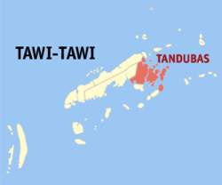 Map of Tawi-Tawi with Tandubas highlighted | |
OpenStreetMap 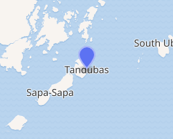
| |
.svg.png) Tandubas Location within the Philippines | |
| Coordinates: 5°08′03″N 120°20′46″E | |
| Country | |
| Region | Bangsamoro Autonomous Region in Muslim Mindanao (BARMM) |
| Province | Tawi-Tawi |
| District | Lone District |
| Founded | July 1, 1958 |
| Barangays | 20 (see Barangays) |
| Government | |
| • Type | Sangguniang Bayan |
| • Mayor | Rahiema A. Salih |
| • Vice Mayor | Fatima Saida A. Maing |
| • Congressman | Rashidin H. Matba |
| • Electorate | 12,299 voters (2019) |
| Area | |
| • Total | 552.05 km2 (213.15 sq mi) |
| Population (2015 census)[3] | |
| • Total | 29,390 |
| • Density | 53/km2 (140/sq mi) |
| • Households | 3,902 |
| Economy | |
| • Income class | 2nd municipal income class |
| • Poverty incidence | 26.01% (2015)[4] |
| • Revenue (₱) | 127,365,178.97 (2016) |
| Time zone | UTC+8 (PST) |
| ZIP code | 7502 |
| PSGC | |
| IDD : area code | +63 (0)68 |
| Climate type | tropical climate |
| Native languages | Sama language Tagalog |
| Website | www |
Geography
The Municipality of Tandubas is located in the north-eastern part of the province of Tawi-Tawi. It is bounded in the north by Languyan Municipality and Sulu Sea; south by Celebes Sea; east by Municipality of South Ubian: and west by Municipality of Sapa-Sapa.
The municipality is approximately 63 kilometres (39 mi) away from the Municipality of Bongao, the capital town of Tawi-Tawi. From Bongao it is accessible by water transportation. Travel time from the port of Bongao to the Municipality of Tandubas takes about five (5) hours using a motor launch with an average speed. For a speedboat or a fast craft it will only take about an hour.
Barangays
Tandubas is politically subdivided into 20 barangays.
- Baliungan
- Kakoong
- Kepeng
- Lahay-lahay
- Naungan
- Sallangan heya & sallangan diki
- Sapa
- Silantup
- Tapian
- Tongbangkaw
- Tangngah (Tangngah Ungus matata)
- Ballak
- Butun
- Himbah
- Kalang-kalang
- Salamat
- Sibakloon
- Tandubato
- Tapian Sukah
- Taruk
12 barangays are located on the island of Tandubas (Tongbangkaw, Tapian, Ballak, Kakoong, Tangngah, Silantup, Butun, Kepeng, Sallangan, Tapian Sokah, Sibakloon and Sapa); 2 barangays are located on Tingungun Island (Kalang-kalang and Salamat); 1 barangay is located at Naungan Island (barangay Naungan); 2 barangays are located on Tandubato island (Lahay-Lahay and Tandubato); 2 barangays are located on Tawitawi Island (Himba and Baliongan), and 1 barangay located on Taruk Island (Barangay Taruk).
Climate
| Climate data for Tandubas, Tawi-Tawi | |||||||||||||
|---|---|---|---|---|---|---|---|---|---|---|---|---|---|
| Month | Jan | Feb | Mar | Apr | May | Jun | Jul | Aug | Sep | Oct | Nov | Dec | Year |
| Average high °C (°F) | 29 (84) |
29 (84) |
29 (84) |
30 (86) |
30 (86) |
30 (86) |
29 (84) |
30 (86) |
30 (86) |
30 (86) |
29 (84) |
29 (84) |
30 (85) |
| Average low °C (°F) | 25 (77) |
24 (75) |
24 (75) |
25 (77) |
25 (77) |
25 (77) |
25 (77) |
25 (77) |
25 (77) |
25 (77) |
25 (77) |
25 (77) |
25 (77) |
| Average precipitation mm (inches) | 157 (6.2) |
115 (4.5) |
123 (4.8) |
96 (3.8) |
136 (5.4) |
120 (4.7) |
104 (4.1) |
89 (3.5) |
86 (3.4) |
131 (5.2) |
151 (5.9) |
159 (6.3) |
1,467 (57.8) |
| Average rainy days | 20.4 | 17.5 | 20.4 | 21.1 | 26.7 | 25.7 | 26.0 | 24.5 | 24.0 | 27.7 | 26.3 | 24.7 | 285 |
| Source: Meteoblue [5] | |||||||||||||
Demographics
| Year | Pop. | ±% p.a. |
|---|---|---|
| 1903 | 3,510 | — |
| 1918 | 9,080 | +6.54% |
| 1939 | 11,342 | +1.06% |
| 1948 | 15,089 | +3.22% |
| 1960 | 20,038 | +2.39% |
| 1970 | 27,069 | +3.05% |
| 1975 | 37,421 | +6.71% |
| 1980 | 19,968 | −11.80% |
| 1990 | 19,505 | −0.23% |
| 1995 | 20,646 | +1.07% |
| 2000 | 24,900 | +4.10% |
| 2007 | 33,037 | +3.98% |
| 2010 | 27,748 | −6.15% |
| 2015 | 29,390 | +1.10% |
| Source: Philippine Statistics Authority[3][6][7][8] | ||
Etymology
The word Tandubas coined from two Malay words Tanjung Bas. Tanjung means “place”, while the word Bas means “Landing”. Therefore, Tandubas means a place of landing, referring to a group of Malaysian traders who sailed across many islands and landed on an island what is now Tandubas Island. Seeing the abundance of resources to sustain their living, this group of Malaysian traders finally decided to settle on that island and named it as Tanjung Bas.
For many years, the island had been named as Tanjung Bas. The Malaysian word Tanjung has its equivalent in Sama dialect which is Tandu. The name Tanjungbas has been changed by the natives to Tandubas, a name that was used from generation to generation.
History
Tandubas had been a part of the Sultanate of Sulu prior to the creation of Sulu as a province under the Republic of the Philippines. When the province of Sulu was created, Tandubas was one of the Districts, an administrative sub-division of the then Department of Education under the Division of Sulu. By virtue of Executive Order No. 355, dated July 1, 1958, Tandubas was converted to a Municipality under the Province of Sulu, covering areas now under the municipality of Sapa-Sapa, the municipality of Languyan, an area in the mainland of Tawi-Tawi. When the Province of Tawi-Tawi was created by virtue of Presidential Decree No. 302, dated September 27, 1973, the Municipality of Tandubas became one of the municipalities in the Province of Tawi-Tawi.
By 2008, the municipality celebrated its Golden Anniversary. In a bid to create more local government units that comprise the Province of Tawi-Tawi, the Municipality of Sapa-Sapa was created entirely from Tandubas Municipality. Also the Municipality of Languyan was created partly out of the territorial jurisdiction of the Municipality of Tandubas, thus greatly reducing the land area of the mother municipality. This was made possible by virtue of Presidential Decree No. 1086.
References
- "Municipality". Quezon City, Philippines: Department of the Interior and Local Government. Retrieved 31 May 2013.
- "Province: Tawi-tawi". PSGC Interactive. Quezon City, Philippines: Philippine Statistics Authority. Retrieved 12 November 2016.
- Census of Population (2015). "ARMM – Autonomous Region in Muslim Mindanao". Total Population by Province, City, Municipality and Barangay. PSA. Retrieved 20 June 2016.
- "PSA releases the 2015 Municipal and City Level Poverty Estimates". Quezon City, Philippines. Retrieved 12 October 2019.
- "Tandubas, Tawi-Tawi : Average Temperatures and Rainfall". Meteoblue. Retrieved 30 January 2019.
- Census of Population and Housing (2010). "ARMM – Autonomous Region in Muslim Mindanao". Total Population by Province, City, Municipality and Barangay. NSO. Retrieved 29 June 2016.
- Censuses of Population (1903–2007). "ARMM – Autonomous Region in Muslim Mindanao". Table 1. Population Enumerated in Various Censuses by Province/Highly Urbanized City: 1903 to 2007. NSO.
- "Province of Tawi‑tawi". Municipality Population Data. Local Water Utilities Administration Research Division. Retrieved 17 December 2016.
External links
Places adjacent to Tandubas, Tawi-Tawi | ||||||||||
|---|---|---|---|---|---|---|---|---|---|---|
| ||||||||||
Bongao (capital) | |
| Municipalities | |