Albay
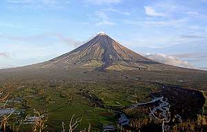
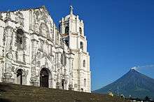
Albay (Central Bicolano: Probinsya kan Albay; Tagalog: Lalawigan ng Albay; Spanish: Provincia de Albay) is a province in the Philippines located in the Bicol Region in Luzon. Its capital is the city of Legazpi, the regional center of the whole Bicol Region, which is located in the southern foothill of Mayon Volcano, the symbol most associated with the province. This perfectly symmetrical active stratovolcano forms a magnificent, scenic backdrop to the city of Legazpi and is visible throughout the municipalities and cities of Albay including the surrounding provinces.[3]
Albay | |
|---|---|
| Province of Albay | |
 Flag  Seal | |
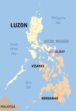 Location in the Philippines | |
| Coordinates: 13°14′N 123°38′E | |
| Country | Philippines |
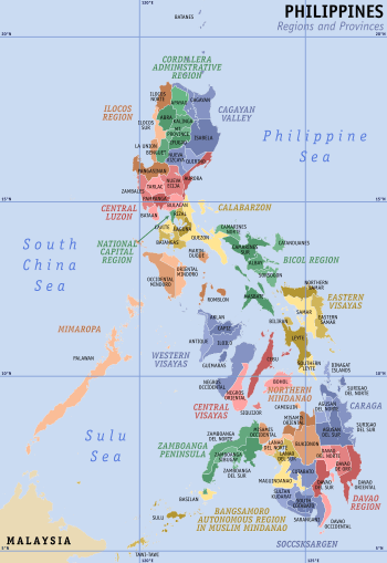
| Region | Bicol Region (Region V) |
| Founded | April 3, 1574 |
| Capital | Legazpi |
| Government | |
| • Type | Sangguniang Panlalawigan |
| • Governor | Al Francis C. Bichara (PDP-LABAN) |
| • Vice Governor | Edcel Greco Alexandre B. Lagman |
| Area | |
| • Total | 2,575.77 km2 (994.51 sq mi) |
| Area rank | 53rd out of 81 |
| Highest elevation (Mount Mayon) | 2,463 m (8,081 ft) |
| Population (2015 census)[2] | |
| • Total | 1,314,826 |
| • Rank | 20th out of 81 |
| • Density | 510/km2 (1,300/sq mi) |
| • Density rank | 12th out of 81 |
| Divisions | |
| • Independent cities | 0 |
| • Component cities | |
| • Municipalities | |
| • Barangays | 720 |
| • Districts | 1st to 3rd districts of Albay |
| Time zone | UTC+8 (PHT) |
| ZIP Code | 4500–4517 |
| IDD : area code | +63 (0)52 |
| ISO 3166 code | PH-ALB |
| Spoken languages | |
| Website | www |
The province was added to the UNESCO World Network of Biosphere Reserves in March 2016.[4]
History
Pre-Hispanic period
Long before the Spaniards arrived, Albay had a thriving civilization. Formerly called Ibat, and then Libog, Albay was once ruled by Gat Ibal, an old chief who also founded the old barangay of Sawangan, now part of the City of Legazpi. Historian William Henry Scott wrote that in the local epic called siday entitled "Bingi of Lawan", an Albay Datu by the name of Dumaraog went to the Lakanate of Lawan to ask for the hands of Bingi bringing with him 100 ships. Lawan is a prosperous Lakanate in Samar. Datu Hadi Iberein came from the Lakanate of Lawan. He was described by Scott as a “Samar datu by the name of Iberein was rowed out to a Spanish vessel anchored in his harbor in 1543 by oarsmen collared in gold; while wearing on his own person earrings and chains.” [5]
Spanish colonial period
In July 1569, Luis Enriquez de Guzman, a member of the expedition led by Maestro de Campo Mateo de Saz and Captain Martin de Goiti, led a group which crossed from Burias and Ticao islands and landed on a coastal settlement called Ibalon in what is now the province of Sorsogon. From this point another expedition was sent to explore the interior and founded the town of Camalig.
In 1573, Juan de Salcedo penetrated the Bicol Peninsula from the north as far south as Libon, establishing the settlement of Santiago de Libon. Jose Maria Peñaranda, a military engineer, was made “corregidor” of the province on May 14, 1834. He constructed public buildings and built roads and bridges.
The entire Bicol Peninsula was organized as one province with two divisions, Camarines in the northwest and Ibalon in the southeast. In 1636, the two partidos were separated, and Ibalon became a separate province with Sorsogon as capital. In the 17th century, Moro slave raiders from southern Philippines ravaged the northeastern coastal areas of the province of Albay.[6]
Mayon Volcano, in one of its most violent eruptions, destroyed the five towns surrounding its base on February 1, 1814. This eruption forced the town of Cagsawa to relocate to its present site, Legazpi.
A decree was issued by Governor-General Narciso Claveria in 1846 separating Masbate, Ticao and Burias from Albay to form the comandancia of Masbate. Albay was then divided into four districts: Iraya, Cordillera or Tabaco, Sorsogon and Catanduanes.
Philippine revolution
Glicerio Delgado, a condemned insurecto (insurgent), started revolutionary activities in the province. With a headquarters in the mountain of Guinobatan town, he joined the revolutionary government of Albay as a lieutenant in the infantry.
A unit of the Philippine Militia was then organized by the Spanish military authorities. Mariano Riosa was appointed major of the Tabaco Zone, which comprised all the towns along the seacoast from Albay to Tiwi while Anacieto Solano was appointed major for the Iraya Zone, which was made up of the towns from Daraga to Libon. Each town was organized into sections of fifty men under the command of a lieutenant.
During the Philippine Revolution on September 22, 1898, the provisional revolutionary government of Albay was formed with Anacieto Solano as provisional president. Major General Vito Belarmino, the appointed military commander, reorganized the Filipino Army in the province.
American colonial period
The sovereignty of the country was transferred to the United States after the Treaty of Paris (1898).[7] During the Philippine–American War, Brigadier General William August Kobbé headed the expedition that landed at the ports of Sorsogon, Bulan and Donsol. From there, the Americans marched to Legazpi and captured it.
Although a civil government was established in Albay on April 26, 1901, Colonel Harry Hill Bandholtz, Commanding Officer of the Constabulary in the Bicol Region, said that General Simeon Ola, with a thousand men, continued to defy American authority after the capture of Belarmino in 1901. Ola was later captured with about six hundred of his men.
World War II
Following the December 12, 1941 Japanese invasion of Legazpi during the Second World War, the Kimura Detachment of the Imperial Japanese Army occupied Albay Province. The region was defended only by the Philippine Constabulary unit under the command of Major Francisco Sandico.[8]
During the Japanese Occupation, the military general headquarters of the Commonwealth Army of the Philippines remained active from January 3, 1942 to June 30, 1946, and the 5th Constabulary Regiment of the Philippine Constabulary was established from October 28, 1944 to June 30, 1946 and stationed in Albay. Then came the clearing operations and anti-Japanese insurgency in the Bicol Peninsula, helped by the local Bicolano resistance. Some Bicolano guerrilla groups invaded around the province of Albay during the Japanese Insurgencies between 1942 and 1944, and were supported by local Filipino troops under the Philippine Commonwealth Army and pre-war Philippine Constabulary 5th Infantry Regiments attacking the enemy soldiers of the Japanese Imperial Army. In the aftermath of three years of siege and conflicts, many Bicolano guerrillas were forced to retreat by the Japanese around the province before liberation in 1945 by Allied forces.
Geography
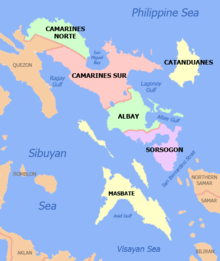
Albay has a total land area of 2,575.77 square kilometres (994.51 sq mi),[9] which makes it the 53rd biggest province. The province is bordered by the provinces of Camarines Sur to the north and Sorsogon to the south. To the northeast lies the Lagonoy Gulf, which separates the province from Catanduanes. To the southwest of the province is the Burias Pass with the island of Burias of Masbate province located about 14 kilometres (8.7 mi) offshore.
In 2016, an area of 250,000 hectares (620,000 acres) was declared a UNESCO Biosphere Reserve. The Albay Biosphere Reserve is home to 182 terrestrial plant species, of which 46 are endemic to the Philippines. Its marine waters and coastal area also provide habitat to five of the world's seven marine turtle species, as well as mangrove, seagrass and seaweed ecosystems.[10]
Topography
The province is generally mountainous with scattered fertile plains and valleys. On the eastern part of the province is a line of volcanic mountains starting with the northernmost Malinao in Tiwi, followed by Mount Masaraga and the free-standing Mayon Volcano. Separated by the Poliqui Bay is the Pocdol Mountains in the town of Manito.
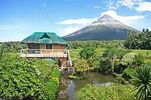
The stratovolcano of Mayon standing at around 2,462 metres (8,077 ft), is the highest point of the province. It is the most famous landform in Albay and in the whole Bicol Region. This active volcano falls under the jurisdiction of eight municipalities and cities of Albay: Camalig, Daraga, Guinobatan, Legazpi City, Ligao City, Malilipot, Santo Domingo, and Tabaco City.
The western coast of the province is mountainous but not as prominent as the eastern range with the highest elevation at around 490 metres (1,610 ft).[11] Among these mountains are Mount Catburawan in Ligao and Mount Pantao in Oas.
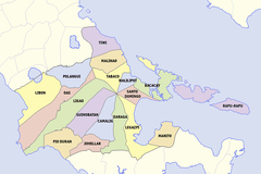
Administrative divisions
Albay comprises 15 municipalities/towns and three component cities (Legazpi, Ligao and Tabaco).
|
| |||||||||||||||||||||||||||||||||||||||||||||||||||||||||||||||||||||||||||||||||||||||||||||||||||||||||||||||||||||||||||||||||||||||||||||||||||||||||||||||||||||||||||||||||||||||||||||||||||||||||||||||||||||||||||||||||||||||||||||||||||||||||||||||||||||||||||||||||||||
Demographics
| Year | Pop. | ±% p.a. |
|---|---|---|
| 1903 | 200,916 | — |
| 1918 | 259,704 | +1.73% |
| 1939 | 333,920 | +1.20% |
| 1948 | 394,694 | +1.88% |
| 1960 | 514,980 | +2.24% |
| 1970 | 673,981 | +2.72% |
| 1975 | 728,827 | +1.58% |
| 1980 | 809,177 | +2.11% |
| 1990 | 903,785 | +1.11% |
| 1995 | 1,005,315 | +2.01% |
| 2000 | 1,090,907 | +1.77% |
| 2007 | 1,190,823 | +1.22% |
| 2010 | 1,233,432 | +1.29% |
| 2015 | 1,314,826 | +1.22% |
| Sources: PSA[2][12][13][14][15] | ||
The population of Albay in the 2015 census was 1,314,826 people,[2], making it the 20th most populous province in the country. It had a density of 510 inhabitants per square kilometre or 1,300 inhabitants per square mile. Based on the 2007 census, there were 208,640 households in the province with an average size of 5.22 persons, significantly higher than the national average of 4.99.
Religion
Catholicism is the predominant religion in the province affiliated by 97% of the Albay population. Each town has its own fiesta for their patrons and patronesses. Other religious denominations are the Iglesia ni Cristo (INC), other Protestant churches such as the Baptist Church, Methodist, other Evangelical Christians, Seventh-day Adventists, Mormons, Jehovah's Witnesses as well as Islam.
Prior to colonization, the region had a complex religious system which involved various deities. Among these deities include: Gugurang, the supreme god who dwells inside of Mount Mayon where he guards and protects the sacred fire in which Aswang, his brother was trying to steal. Whenever people disobey his orders, wishes and commit numerous sins, he would cause Mount Mayon to burst lava as a sign of warning for people to mend their crooked ways. Ancient Bikolanos had a rite performed for him called Atang.;[16][17] Asuang, the evil god who always try to steal the sacred fire of Mount Mayon from his brother, Gugurang. Addressed sometimes as Aswang, he dwells mainly inside Mount Malinao. As an evil god, he would cause the people to suffer misfortunes and commit sins.[16][17] Enemy of Gugurang and a friend of Bulan the god of the moon; Haliya, the masked goddess of the moonlight and the arch-enemy of Bakunawa and protector of Bulan. Her cult is composed primarily of women. There is also a ritual dance named after her as it is performed to be a counter-measure against Bakunawa.;[18] Bulan, the god of the pale moon, he is depicted as a pubescent boy with uncommon comeliness that made savage beast and the vicious mermaids (Magindara) tame. He has deep affection towards Magindang, but plays with him by running away so that Magindang would never catch him. The reason for this is because he is shy to the man that he loves. If Magindang manages to catch Bulan, Haliya always comes to free him from Magindang's grip; Magindang, the god of the sea and all its creatures. He has deep affection to the lunar god Bulan and pursues him despite never catching him. Due to this, the Bicolanos reasoned that it is to why the waves rise to reach the moon when seen from the distant horizon. Whenever he does catch up to Bulan, Haliya comes to rescue Bulan and free him immediately; Okot, god of forest and hunting; and Bakunawa, a gigantic sea serpent deity who is often considered as the cause of eclipses, the devourer of the sun and the moon, and an adversary of Haliya as Bakunawa's main aim is to swallow Bulan, who Haliya swore to protect for all of eternity.[19]
Languages
Albay is home to several languages and host to different native languages of Bicol Region. Out of seven Bikol languages (excluding the Bisakol languages, which are Bisayan languages), only Pandan Bikol of northern Catanduanes is not used or which the origin is not from Albay. The languages in the province is very diverse which includes the languages of Albay Bikol group which comprises the languages of West Miraya, East Miraya, Libon and Buhinon. Of the four Albay Bikol languages, Buhinon is the only one not used in Albay but rather in Buhi, Camarines Sur.
Rinconada Bikol is a minority language in the province and used by people in barangays of Libon and Polangui that are near the boundary of Bato and Iriga City in Camarines Sur. Another primary language used in the province is Central Bikol which is the native-tongue of the population on the eastern coast of the Bicol Peninsula. Both Albay Bikol languages and Rinconada Bikol are members of Inland Bikol group of languages while Central Bikol is a language member of Coastal Bikol. The Tabaco-Legazpi-Sorsogon dialect of Central Bikol is spoken in Legazpi City, Tabaco City and neighboring municipalities on the east side of Albay, and some parts of northern Sorsogon (especially in Sorsogon City).
The majority of the inhabitants also understand English and Filipino as second languages.
Economy
Agriculture is the main industry in Albay, which produces crops like coconut, rice, sugar and abacá. Handicrafts are the major source of rural income and comprises a fairly large share in the small-scale industries of the province. Forestry, cement production and paper-making are other sources of livelihood. The manufacture of abacá products such as Manila hemp, hats, bags, mats, furniture, home decors,[20] and slippers is one of the main sources of income in the rural areas. Production of abaca fiber experienced a boom from the late 1800s until the American period.[21] Fishing is the main livelihood along both shores of the province. Tourism, especially related to Mayon Volcano, also creates income for Albay. For the year 2013, Albay had a total of 339,445 foreign tourist arrivals.
Government
Albay has three congressional districts encompassing its 18 municipalities and 3 component cities.
| District | Representative[22] | City or municipality | District population (2015) |
|---|---|---|---|
| 1st (Coastal District) | Edcel C. Lagman |
|
373,947 |
| 2nd (Capital District) | Joey Sarte Salceda | 451,765 | |
| 3rd (Miraya District) | Fernando V. Gonzalez | 489,114 |
Transportation
Roads
Albay has 383.22 kilometers (238.12 mi) of national roads, mostly paved with asphalt, with 5.25 kilometers (3.26 mi) remaining unpaved.[23] Maharlika Highway (N1/AH26) serves as the principal road connection between other provinces. Most of the province are served by secondary national roads, assigned route numbers of the 630 and 640 series. Almost all of the cities and municipalities are connected by national roads, except for Rapu-Rapu.
Water transport
Albay is the region's principal trans-shipment point with its ports: Tabaco International Port, Legazpi National Port, Pio Duran Provincial Port, and the Pantao Regional Port.
Air transport
Traveling to the province by air is served by the Legazpi Airport, the province's gateway from Manila and Cebu City in the Visayas. The larger Bicol International Airport is under construction in the municipality of Daraga, adjacent municipality of Legazpi City.
Railroads
Albay is served by the mainline of the Philippine National Railways (PNR), and has commuter service between Naga in Camarines Sur. Trains to Manila (Tutuban), the Mayon Limited, is suspended from November 2012. Four stations serve Polangui, Ligao, Guinobatan, and Legaspi, respectively.
 Aerial view of the Legazpi Grand Central Terminal
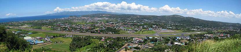 The runway of Legazpi Airport
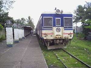 A PNR train in Ligao railway station
References
- "The province of Albay". Overview of the Region. Makati City, Philippines: National Statistical Coordination Board. Archived from the original on 13 November 2012. Retrieved 11 January 2013.
- Census of Population (2015). "Region V (Bicol Region)". Total Population by Province, City, Municipality and Barangay. PSA. Retrieved 20 June 2016.
- Facts about Mayon Volcano" Archived 2012-04-09 at the Wayback Machine. Albay Tourism. Retrieved on 2012-05-27.
- "20 sites added to UNESCO's World Network of Biosphere Reserve". United Nations Educational Scientific and Cultural Organization. 2016-03-19. Retrieved 2016-03-20.
- Scott, William Henry (1985). Cracks in the parchment curtain and other essays in Philippine history. New Day Publishers. p. 93. ISBN 978-971-10-0073-8.
- source?
- McKinley, William (1898). "The Acquisition of the Philippines from Papers Relating to Foreign Affairs". Vincent Ferraro, Mount Holyoke College. Retrieved on 2012-05-18.
- "History of Albay" Archived 2010-08-19 at the Wayback Machine. Royal quest Tour.
- "Province: Albay". PSGC Interactive. Quezon City, Philippines: Philippine Statistics Authority. Retrieved 8 January 2016.
- UNESCO Press (19 March 2016). "20 sites added to UNESCO's World Network of Biosphere Reserves". United Nations Educational, Scientific and Cultural Organization. Retrieved 21 March 2016.
- "Mount Pantao, Oas". Google Maps. Retrieved on 2012-05-27.
- Census of Population and Housing (2010). "Region V (Bicol Region)". Total Population by Province, City, Municipality and Barangay. NSO. Retrieved 29 June 2016.
- Census of Population and Housing (2010). Population and Annual Growth Rates for The Philippines and Its Regions, Provinces, and Highly Urbanized Cities (PDF). NSO. Retrieved 29 June 2016.
- Censuses of Population (1903–2007). "Region V (Bicol Region)". Table 1. Population Enumerated in Various Censuses by Province/Highly Urbanized City: 1903 to 2007. NSO.
- "Census 2000; Population and Housing; Region V" (PDF). Philippine Statistics Authority (Philippine Statistics Authority - Region V). Retrieved 29 June 2016.
- "Asuang Steals Fire from Gugurang by Damiana L. Eugenio". Archived from the original on 2009-05-26. Retrieved 2010-04-03.
- Clark, Jordan (2011) The Aswang Phenomenon Animation https://www.youtube.com/watch?v=goLgDpSStmc
- "Inquirer NewsInfo: Bicol Artist protest Natl. Artist awardees". Archived from the original on 2009-09-11. Retrieved 2010-04-03.
- "GMANews: Eclipse; Bakunawa eats the sun behind a curtain of clouds". Retrieved 2010-04-03.
- Valmero, Anna (15 September 2011). "Bicolano entrepreneur finds success in abaca furniture". loQal.ph. Archived from the original on 2 May 2014. Retrieved 29 June 2016.
- Prosperity Without Progress: Manila Hemp and Material Life in the Colonial Philippines, p. 108, at Google Books
- "House Members; 17th Congress". House of Representatives of the Philippines. Retrieved 7 August 2016.
- Figures tabulated from data by the Department of Public Works and Highways district engineering offices in Albay. See 2015 DPWH Atlas for Region V
External links
| Wikivoyage has a travel guide for Albay. |


- New Albay Tourism Promotion Website
- Province of Albay Official Website
Places adjacent to Albay | ||||||||||
|---|---|---|---|---|---|---|---|---|---|---|
| ||||||||||
Legazpi (capital) | |
| Municipalities | |
| Component cities | |
| Authority control |
|
|---|