Tagoloan II
Tagoloan II, officially the Municipality of Tagoloan II (Maranao: Inged a Tagoloan II; Tagalog: Bayan ng Tagoloan II), is a 4th class municipality in the province of Lanao del Sur, Philippines. According to the 2015 census, it has a population of 11,169 people.[3]
Tagoloan II | |
|---|---|
| Municipality of Tagoloan II | |
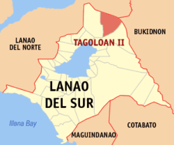 Map of Lanao del Sur with Tagoloan II highlighted | |
OpenStreetMap 
| |
.svg.png) Tagoloan II Location within the Philippines | |
| Coordinates: 8°06′33″N 124°26′21″E | |
| Country | |
| Region | Bangsamoro Autonomous Region in Muslim Mindanao (BARMM) |
| Province | Lanao del Sur |
| District | 1st District |
| Barangays | 19 (see Barangays) |
| Government | |
| • Type | Sangguniang Bayan |
| • Mayor | Cosain L. Capal |
| • Vice Mayor | Mangondaya L. Capal |
| • Congressman | Ansaruddin Abdul Malik A. Adiong |
| • Electorate | 11,320 voters (2019) |
| Area | |
| • Total | 362.35 km2 (139.90 sq mi) |
| Population (2015 census)[3] | |
| • Total | 11,169 |
| • Density | 31/km2 (80/sq mi) |
| • Households | 1,283 |
| Economy | |
| • Income class | 4th municipal income class |
| • Poverty incidence | 78.23% (2015)[4] |
| • Revenue (₱) | 80,864,934.79 (2016) |
| Time zone | UTC+8 (PST) |
| ZIP code | 9321 |
| PSGC | |
| IDD : area code | +63 (0)63 |
| Climate type | tropical climate |
| Native languages | Maranao Tagalog |
| Website | www |
It is situated in the northern part of the Province of Lanao del Sur, containing a total land area of 60,214 hectares, more or less. This area is based on the territorial jurisdiction covered by those barangays (39 Barangays) named in the Presidential Decree 1548 dated June 11, 1978,[5] otherwise known as the "charter creation of the Municipality of Tagoloan II in the Province of Lanao del Sur" which hereby described as follows;
Bounded on the east by Cagayan river (Municipality of Talakag, Province of Bukidnon); on the south by Municipality of Bubong, Province of Lanao del Sur; on the south-west by Municipality of Kapai, Province of Lanao del Sur and Municipality of Tagoloan, Province of Lanao del Norte; on the west by City of Iligan; on the north by Cagayan de Oro City, Province of Misamis Oriental.
Barangays
Municipality of Tagoloan II is politically subdivided into thirty-nine (39) barangays under the P.D. 1548 dated June 11, 1978[5] and was then reduced into nineteen (19) barangays, as affected by E.O. No. 108, Series of 1986[6] namely, are;
- Bantalan
- Bayog
- Cadayonan
- Dagonalan
- Domalama
- Gayakay
- Inudaran
- Kalilangan
- Kianibong
- Kinggan
- Kita-o-an
- Bago-ah Ingud
- Malinao
- Malingun
- Mama-an Pagalongan
- Marawi
- Mimbaguiang
- Sigayan
- Tagoloan Poblacion
Climate
| Climate data for Tagoloan II, Lanao de Sur | |||||||||||||
|---|---|---|---|---|---|---|---|---|---|---|---|---|---|
| Month | Jan | Feb | Mar | Apr | May | Jun | Jul | Aug | Sep | Oct | Nov | Dec | Year |
| Average high °C (°F) | 22 (72) |
23 (73) |
24 (75) |
24 (75) |
24 (75) |
23 (73) |
23 (73) |
24 (75) |
24 (75) |
24 (75) |
23 (73) |
23 (73) |
23 (74) |
| Average low °C (°F) | 18 (64) |
18 (64) |
18 (64) |
19 (66) |
20 (68) |
19 (66) |
19 (66) |
19 (66) |
19 (66) |
19 (66) |
19 (66) |
18 (64) |
19 (66) |
| Average precipitation mm (inches) | 159 (6.3) |
143 (5.6) |
166 (6.5) |
183 (7.2) |
357 (14.1) |
414 (16.3) |
333 (13.1) |
309 (12.2) |
289 (11.4) |
285 (11.2) |
253 (10.0) |
166 (6.5) |
3,057 (120.4) |
| Average rainy days | 18.4 | 17.2 | 20.6 | 23.4 | 29.3 | 29.2 | 29.9 | 29.4 | 27.7 | 28.7 | 25.5 | 19.9 | 299.2 |
| Source: Meteoblue [7] | |||||||||||||
Demographics
| Year | Pop. | ±% p.a. |
|---|---|---|
| 1970 | 1,853 | — |
| 1975 | 2,305 | +4.47% |
| 1980 | 4,876 | +16.16% |
| 1990 | 7,414 | +4.28% |
| 1995 | 7,760 | +0.86% |
| 2000 | 8,714 | +2.52% |
| 2007 | 11,144 | +3.45% |
| 2010 | 9,843 | −4.42% |
| 2015 | 11,169 | +2.44% |
| Source: Philippine Statistics Authority[3][8][9][10] | ||
Etymology
Tagoloan is a compound word composed of two (2) "maranao" terms connected together. The term, "Tago" refers to something inside, "the content", which is refers to the, "inhabitants", and "oloan", a noun means "leader" in which in its adjective form is, "chief or head" in terms of leading a position in a community or village or a clan.
In today's political and administrative system of government by some other Muslim countries, the leader, head or chief of the state is called a "Sultan". In the present traditional government of the "Moro" nation, the head of the community or town and or a region is so-called a, "Sultan"(e.g.; Sultan of Bayog, Sultan of Dimakiling, Sultan of Kapai, Sultan of Ramain, Sultan of Masiu, Sultan of Ragayan sa Unayan, and the like)". The term "Sultan" is originally an Arabic word,[11] a title, which is particularly addressed to a "muslim ruler" of a certain state or community, i.e.; Sultans of Oman;[12]
The word "inhabitants" stated in the above paragraph is referring to the people of Tagoloan in general, while “oloan”, a maranao term meaning leader referred to Sharif Alawi. In short, people of Tagolaon are descent from Sharif Alawi".
“Sharif” is an Arabic word, in its adjective form meaning, “noble" or a Muslim ruler, magistrate, religious leader.[13]
Sultan Sharif Alawi, established the Sultanate of Tagoloan in 1500. Some local historians say it was in the year 1515[14] while Sultan Sharif Kabunsuan enthroned as the First Sultan of Maguindanao in the year 1520[15]. Sharif Alawi is the eldest brother of Sharif Kabunsuan.
Sharif Alawi and Sharif Kabunsuan came from Johore, a state in Malaysia and firstly landed in Mindanao in the year 1475 at the islet (now Agutayan reef, in Jasaan, Misamis Oriental,[16] visible from the seaport of the Municipality of Tagoloan in the Province of Misamis Oriental, Northern Mindanao. Other local moro historian mentioned that these brothers arrived in Mindanao in the year 1464[14]
Sultan Sharif Alawi spread Islam (prior to the arrival of Christianity in Philippine in 1521), in this town towards Surigao, Butuan, Bukidnon, Davao, Lanao del Sur and Norte, stretching towards Misamis Occidental in western Mindanao, while Sultan Sharif Kabunsuan only preached Islam in Maguindanao.
The Roman numeral "II" was added to distinguish the municipality from another municipality with a similar name when Lanao was a single province. Though Lanao was divided into two in 1959, the numeral "II" has not removed since.
References
- "Municipality". Quezon City, Philippines: Department of the Interior and Local Government. Retrieved 31 May 2013.
- "Province: Lanao del Sur". PSGC Interactive. Quezon City, Philippines: Philippine Statistics Authority. Retrieved 12 November 2016.
- Census of Population (2015). "ARMM – Autonomous Region in Muslim Mindanao". Total Population by Province, City, Municipality and Barangay. PSA. Retrieved 20 June 2016.
- "PSA releases the 2015 Municipal and City Level Poverty Estimates". Quezon City, Philippines. Retrieved 12 October 2019.
- http://www.lawphil.net/statutes/presdecs/pd1978/pd_1548_1978.html
- gov.ph
- "Tagoloan II, Lanao del Sur : Average Temperatures and Rainfall". Meteoblue. Retrieved 27 January 2019.
- Census of Population and Housing (2010). "ARMM – Autonomous Region in Muslim Mindanao". Total Population by Province, City, Municipality and Barangay. NSO. Retrieved 29 June 2016.
- Censuses of Population (1903–2007). "ARMM – Autonomous Region in Muslim Mindanao". Table 1. Population Enumerated in Various Censuses by Province/Highly Urbanized City: 1903 to 2007. NSO.
- "Province of Lanao del Sur". Municipality Population Data. Local Water Utilities Administration Research Division. Retrieved 17 December 2016.
- http://www.thefreedictionary.com/sultan
- http://www.encyclopedia.com/topic/Sultan_of_Oman_Qaboos_bin_Said.aspx
- https://en.oxforddictionaries.com/definition/sharif
- https://acmaly88.page.tl/TAGOLOAN-SULTANATE--.htm
- Confederation of sultanates in Lanao
- http://wikimapia.org/#lang=en&lat=8.667748&lon=124.712420&z=14&m=b&search=Tagoloan%2C%20Misamis%20Oriental
External links
- Tagoloan II Profile at PhilAtlas.com
- Philippine Standard Geographic Code
- Philippine Census Information
- Local Governance Performance Management System
Places adjacent to Tagoloan II | ||||||||||
|---|---|---|---|---|---|---|---|---|---|---|
| ||||||||||