Marinduque
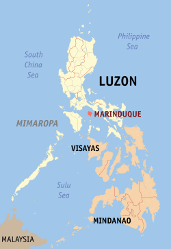
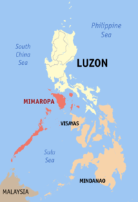
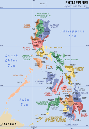
Marinduque (Tagalog pronunciation: [maɾinˈduke]) is an island province in the Philippines located in Southwestern Tagalog Region or Mimaropa, formerly designated as Region IV-B. Its capital is the municipality of Boac. Marinduque lies between Tayabas Bay to the north and Sibuyan Sea to the south. It is west of the Bondoc Peninsula of Quezon province; east of Mindoro Island; and north of the island province of Romblon. Some parts of the Verde Island Passage, the center of the center of world's marine biodiversity and a protected marine area, are also within Marinduque's provincial waters.
Marinduque | |
|---|---|
| Province of Marinduque | |
     (From top, left to right:)
| |
 Flag  Seal | |
 Location in the Philippines | |
| |
| Coordinates: 13°24′N 121°58′E | |
| Country | Philippines |
| Region | Mimaropa (Region IV-B) |
| Founded | February 21, 1920 |
| Capital | Boac |
| Government | |
| • Type | Sangguniang Panlalawigan |
| • Governor | Presbitero J. Velasco Jr. (PDP-Laban) |
| • Vice Governor | Romulo A. Bacorro Jr. (PDP-Laban) |
| • Representative | Lord Allan Jay Q. Velasco (PDP-Laban) Lone District |
| Area | |
| • Total | 952.58 km2 (367.79 sq mi) |
| Area rank | 76th out of 81 |
| Highest elevation | 1,157 m (3,796 ft) |
| Population (2015 census)[2] | |
| • Total | 234,521 |
| • Rank | 69th out of 81 |
| • Density | 250/km2 (640/sq mi) |
| • Density rank | 37th out of 81 |
| Divisions | |
| • Independent cities | 0 |
| • Component cities | 0 |
| • Municipalities | |
| • Barangays | 218 |
| • Districts | Lone district of Marinduque |
| Time zone | UTC+8 (PHT) |
| ZIP code | 4900–4905 |
| IDD : area code | +63 (0)42 |
| ISO 3166 code | PH-MAD |
| Spoken languages | |
| Website | www |
The province of Marinduque was ranked number 1 by the Philippine National Police and Philippine Security Forces as the 2013 Most Peaceful Province of the country due to its low crime rate statistics alternately ranking with the province of Batanes yearly. Furthermore, for almost 200 years, the province is home to one of the oldest religious festivals of the country, the Moriones celebrated annually every Holy Week.
History
The most accepted theory of the etymology of the province's name is a Hispanized corruption of either malindig or malindug, which means "stand tall" or "elegant", in reference to a potentially active volcano in the southern section of the island, the Mount Malindig.[3] Domingo Navarette ('Tratados...', 1676) wrote "The island which the natives call Minolo is named Mindoro by the Spaniards, and that of Malindic we call Marinduque." (trans. by Blair and Robertson).[4]
During the Spanish and early American occupations, Marinduque was part of Balayan Province (now Batangas) in the 16th century, Mindoro in the 17th century, and had a brief period as an independent province in 1901, when the Americans arrived.
During the Philippine-American War, Marinduque was the first island to have American concentration camps.[5] Marinduque is the site of the Battle of Pulang Lupa, where 250 Filipino soldiers under Colonel Maximo Abad, defeated a smaller force of 54 American Infantrymen. It is one of the few battles during the pacification of the Philippines where the tenacity and bravery of the Filipinos prevailed over the well-armed Americans. Col. Abad after capturing the Americans later surrendered on April 15, 1901 upon orders from Gen. Emilio Aguinaldo and due to the capture of Gov. Martin Lardizabal and two other officials of the revolutionary who were held hostage by the Americans in Fort Santiago.[6]:535
In 1902, the US-Philippine Commission annexed the islands of Mindoro (now two separate provinces) and Lubang (now part of Occidental Mindoro) to the province.
Four months later, the province became part of the province of Tayabas (now Quezon).
On February 21, 1920, Act 2280 was passed by the Philippine Congress, reestablishing Marinduque as a separate province.
In 1942 during the Second World War, the Japanese Imperial forces landed in Marinduque.
In 1945, combined American and Filipino troops liberated the province from the Japanese forces. Two government agencies were stationed in the province during the American period, the Philippine Commonwealth Army and the Philippine Constabulary. The general headquarters of the PCA was active from 1935 to 1942 and again from 1945 to 1946 while the PC was active from 1945 to 1946.
Archaeological finds
Archaeology in the Philippines began in Marinduque. Prior to 1900, only one important archaeological investigation had been carried out in the country: the Antoine-Alfred Marche’s exploration of Marinduque from April to July 1881. According to anthropologist Henry Otley Beyer, while many other accidental discoveries and finds have been recorded from time to time and a few burial caves and sites had been casually explored by European and local scientists, no systematic work had been done anywhere else prior to these explorations. After Marche, the next important archaeological work was undertaken by Dr. Carl Gunthe in the Visayas Island Group in 1922.
An abundant yield of Chinese urns, vases, gold ornaments, skulls and other ornaments of pre-colonial origin was what Marche finds represented. He brought back to France the Marinduque artifacts he uncovered in 40 crates. Part of it now is said to be housed at the Musée de l'Homme in France. The finds also included a wooden image of the Marinduque anito called "Pastores" by the natives.
One of these artifacts also found its way into the National Museum of Natural History of the Smithsonian Institution in Washington, D.C. (Catalogue No. A127996-0, Department of Anthropology, NMNH, Smithsonian Institution). These fragile jarlets traveled from China to the pre-colonial Philippines. Buried in a cave in Marinduque for centuries, excavated in the late 19th century, brought to Paris and eventually one ended up at the Smithsonian Institution museum.
Part of Marinduque's history lies at the Marinduque Museum in Poblacion at Boac and in museums abroad. It will take some time to analyze these artifacts to piece together its pre-colonial past.
Geography
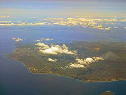
Marinduque is considered as the geographical center of the Philippine archipelago by the Luzon Datum of 1911, the mother of all Philippine geodetic surveys. The province is a "heart-shaped" island with a total land area of 952.58 square kilometres (367.79 sq mi)[7], situated between Tayabas Bay in the north and Sibuyan Sea to the south. It is separated from the Bondoc Peninsula in Quezon by the Mompong Pass. West of Marinduque is Tablas Strait, which separates it from Mindoro Island. Some of the smaller islands to the northeast are Polo Island, Maniwaya Island, and Mompong Island. Southwest portion includes the Tres Reyes Islands and Elephant Island.
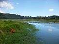
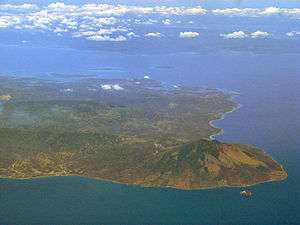
The highest peak in Marinduque is Mount Malindig (formerly called Mt. Marlanga), a potentially active stratovolcano with an elevation of 1,157 metres (3,796 ft) above sea level, located at the southern tip of the island. Various cave systems occupy the province, which include the grand Bathala Cave; the newly discovered San Isidro Cave with its complex subterranean river; and Talao Caves with its 12 series of caves overlooking the western part of the island.
Climate
Marinduque has a Type III climate, having rainfall more or less evenly distributed throughout the year with no clear boundary between dry and wet seasons. The annual mean, maximum, and minimum temperatures were calculated at 27.0 °C (80.6 °F), 32.9 °C (91.2 °F) and 22.3 °C (72.1 °F) respectively. Humidity average is 78% year-round with an average annual rainfall totaling 2,034.6 mm (80.1 inches).[8]
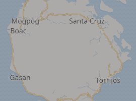
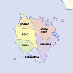
Administrative divisions
Marinduque comprises 6 municipalities, further subdivided into 218 barangays. A double legislative districts encompasses all towns.[7]
| Municipality [lower-roman 1] | Population | ±% p.a. | Area[7] | Density (2015) | Barangay | |||||||
|---|---|---|---|---|---|---|---|---|---|---|---|---|
| (2015)[2] | (2010)[9] | km2 | sq mi | /km2 | /sq mi | |||||||
| Boac | † | 23.3% | 54,730 | 52,892 | +0.65% | 212.70 | 82.12 | 260 | 670 | 61 | ||
| Buenavista | 10.2% | 23,988 | 23,111 | +0.71% | 81.25 | 31.37 | 300 | 780 | 15 | |||
| Gasan | 14.9% | 34,828 | 33,402 | +0.80% | 100.88 | 38.95 | 350 | 910 | 25 | |||
| Mogpog | 14.5% | 34,043 | 33,384 | +0.37% | 108.06 | 41.72 | 320 | 830 | 37 | |||
| Santa Cruz | 24.1% | 56,408 | 55,673 | +0.25% | 270.77 | 104.54 | 210 | 540 | 55 | |||
| Torrijos | 13.0% | 30,524 | 29,366 | +0.74% | 178.92 | 69.08 | 170 | 440 | 25 | |||
| Total | 234,521 | 227,828 | +0.55% | 952.58 | 367.79 | 250 | 650 | 218 | ||||
| † Provincial capital | Municipality | |||||||||||
| ||||||||||||
- Boac
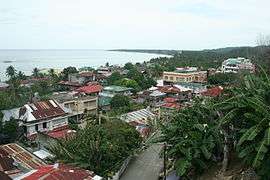
- The capital of the province. Although the second most populous after Santa Cruz, Boac remains the center of industry, culture, economy and education. Most of government and private offices are in the municipality of Boac. It also borders all the five municipalities. Mogpog to the North, Santa Cruz to the Northeast, Torrijos to the East, Buenavista to the South and Gasan to the Southwest. Boac is named after the Tagalog word, biak, which means divided, due to the Boac River dividing the town in the geographic north and south.
- Gasan
- The Cultural Nerve Center of the province. Dubbed as one of the cleanest and greenest municipalities in the Philippines, Gasan's land area covers a forest reserve in the eastern part. It is also the gateway to the island of Mindoro. Handicrafts and the famous Kalutang boasts from the town of Gasan. It was named after gasang-gasang, a local term for corals found in the municipality.
- Buenavista
- The smallest of the six municipalities. It was once part of the municipality of Gasan known as Sabang. It was named such because of the "good view" of the Tablas Strait and offshore islands.
- Torrijos
- Named after three purported origins; 1) from Gen. Torrijos, 2) from torrillos, referring to the cows which pastured in its vast plains, and 3) from torre y hijos, referring to the watchtower men guarding the parish. Torrijos is deemed to be the summer Capital of the Province and known for locally-grown strawberries.
- Santa Cruz
- The largest of all the six municipalities both in land area and population. It is considered as a secondary municipality after Boac (since it is the capital). Together with Boac, it is also a first-class municipality with established industries and commercial routines.
- Mogpog
- The Primary Gateway of the Province through the Balanacan Port. It is the original home of the Moriones Lenten Rites and Kangga Festiva. Mogpog was named after the Tagalog word, mag-aapog or kiln makers abundant in the municipality.
Demographics
| Year | Pop. | ±% p.a. |
|---|---|---|
| 1903 | 51,674 | — |
| 1918 | 56,868 | +0.64% |
| 1939 | 81,768 | +1.74% |
| 1948 | 85,828 | +0.54% |
| 1960 | 114,586 | +2.44% |
| 1970 | 144,109 | +2.32% |
| 1975 | 162,804 | +2.48% |
| 1980 | 173,715 | +1.31% |
| 1990 | 185,524 | +0.66% |
| 1995 | 199,910 | +1.41% |
| 2000 | 217,392 | +1.81% |
| 2007 | 229,636 | +0.76% |
| 2010 | 227,828 | −0.29% |
| 2015 | 234,521 | +0.55% |
| Source: Philippine Statistics Authority[2][9][10][11] | ||
The population of Marinduque in the 2015 census was 234,521 people,[2] with a density of 250 inhabitants per square kilometre or 650 inhabitants per square mile, hence, it is the most densely populated province in the Mimaropa Region.
Religion
Marinduque is resided by various religious groups, with Catholics belonging to the Latin Rite predominantly making up the greatest number with 70%. The Iglesia Filipina Independiente has 25% of the population and the rest belongs to the different denominations such as The Church of Jesus Christ of Latter-day Saints, Iglesia ni Cristo, and various Mainline Protestant denominations which include Assemblies of God, Baptists, JIL, Methodists, Presbyterian, Seventh-day Adventist Church (SDA), and the non-denominational Evangelical churches also known as Born-Again Christians. Muslims, Anitists, animists, and atheists are also present in the province.
Language
The version of Tagalog spoken in Marinduque, known as the Marinduque Tagalog, has been described as "the root from which modern national forms of speech have sprung," where remnants of archaic Tagalog could be found, spoken in a lilting manner by its inhabitants. If this linguistic theory is accurate, Marinduque's Tagalog has contributed significantly to the development of the official Philippine national language.[12]
To this day, Marinduqueños speak an old variation of the Tagalog language that is very close to the way Tagalog was spoken before the Spanish colonization. According to language experts , the Tagalog dialects of Marinduque are the most divergent, especially the Eastern Marinduque dialect, perhaps due to the relative isolation from the Tagalogs of Luzon and also perhaps due to the influence of the Visayan and Bikol migrants.[13]
Linguist Rosa Soberano's 1980 The Dialects of Marinduque Tagalog goes into great depth concerning the dialects spoken there. The following is a verb chart which outlines the conjugation of the Eastern Marinduque dialect of Tagalog:
| Infinitive | Contemplative (future actions) |
Progressive (past and present actions) |
Completed (past actions) |
Imperative | |
|---|---|---|---|---|---|
| Actor Focus 1 | -um-
(gumawa) (future actions) |
má-
(mágawâ) |
ná-
(nágawâ) |
-um-
(gumawa) |
0
(gawa) |
| Actor Focus 2 | mag-
(magbigay) |
(ma)ga-
([ma]gabigay) |
naga-
(nagabigay) |
nag-
(nagbigay) |
pag-
(pagbigay) |
| Object Focus 1 | -in
(kainin) |
a-
(akainin) |
ina-
(inakain) |
-in-
(kinain) |
-a
(kaina) |
| Object Focus 2 | i-
(isulat) |
a-
(asulat) |
ina-
(inasulat) |
i- -in-
(isinulat) |
-an
(sulatan) |
| Object Focus 3 | -an
(tawagan) (future actions) |
a-...-an
(atawagan) |
ina- ... -an
(inatawagan) |
-in- ... -an
(tinawagan) |
-i
(tawagi) |
Linguist Christopher Sundita observed that some of the affixes in Marinduque Tagalog, particularly "a-" and "ina-," are affixes used in Asi (Bantoanon), a Visaya language spoken in Romblon, just south of Marinduque. Marinduque Tagalog, like the Tagalog spoken over two centuries ago, had an additional verb category, the imperative, which was used for commands and requests (e.g., Matulog ka na - Go to sleep). Even then, the imperative and the infinitive were used side by side in expressing commands; but in standard Tagalog, apparently the infinitive became used exclusively. And in the Eastern Marinduque dialect, the imperative affixes are very much alive.[14]
Economy
Marinduque is an agricultural province, primarily growing rice and coconuts. Handicrafts from Marinduque are also exported to dıfferent parts of the world, and fishing is another important part of the economy. Mining was once an important player in the economy until a mining accident (the Marcopper Mining Disaster) occurred, bringing the industry to a standstill on the island and causing enormous damage to the inhabitants. The provincial government has just recently sued Marcopper's parent company, Placer Dome, for $100 million in damages. Placer Dome was purchased in 2006 by Barrick Gold, who has now been joined in the lawsuit.
A significant role in Marinduque's economy is also played by tourism, especially during the Lenten season. While this is not one of the larger parts of the island's economy, it has shown great growth. Recently, some residents are now engaged in butterfly farming. Butterflies are raised for export to countries in both Europe and the Americas. Locally, live butterflies are released in celebration on different occasions, such as birthdays, weddings, and some corporate events.
Culture
Festivals
The Moriones Festival is an annual festival, locally known as "Moryonan", celebrated in Marinduque from March to April. In Santa Cruz, Gasan, Boac, and Mogpog, a parade of people dressed as "Moryons" can be seen on the main road connecting the towns of the island. Boac and Santa Cruz, the biggest towns in the province, shows a reenactment in the evening of the actual event when Longinus, a blind soldier, punctures Jesus with his spear and blood droplets from the wound restores Longinus'sight.
Music
Marinduque is home to the kalutang, a musical instrument made of two pieces of wood that produce different note ranges depending on its size. A band of 10 to 12 can create music with this instrument.[15] In 2011, the kalutang instrument was cited by the National Commission for Culture and the Arts as one of the intangible cultural heritage of the Philippines under the traditional craftsmanship category that the government may nominate in the UNESCO Intangible Cultural Heritage Lists.[16]
Government
Marinduque has had its own Governor since becoming a sub-province of Tayabas (now Quezon) in 1902 and after gaining its independence from Tayabas in 1920.
| Year range | Name |
|---|---|
| As a sub-province under Tayabas | |
| 1898 — 1901 | Martin Lardizabal |
| 1901 — 1907 | Ricardo Paras |
| 1907 — 1916 | Juan Nieva |
| 1916 — 1919 | Pedro Madrigal |
| 1919 — 1920 | Vicente Triviño |
| As an independent province | |
| 1920 — 1922 | Vicente Triviño |
| 1922 — 1925 | Miguel Villamayor |
| 1925 — 1933 | Damian J. Reyes |
| 1933 — 1936 | Pedro del Mundo |
| 1936 — 1938 | Leon Pelaez |
| 1938 — 1941 | Ramon Reynoso |
| 1941 — 1945 | Jose L. Basa |
| 1945 — 1946 | Ricardo Nepomuceno |
| 1946 — 1951 | Cesar L. Nepomuceno |
| 1951 — 1963 | Miguel M. Manguera |
| 1963 — 1967 | Celso L. Preclaro |
| 1967 — 1988 | Aristeo Marasigan Lecaroz |
| 1988 — 1995 | Luisito Mercader Reyes |
| 1995 — 1998 | Jose Antonio Nieva Carrion |
| 1998 — 2007 | Carmencita Ongsiako Reyes |
| 2007 — 2010 | Jose Antonio Nieva Carrion |
| 2010 — 2019 | Carmencita O. Reyes |
| 2019 | Romulo Aguinaldo Bacorro Jr. |
| 2019 — present | Presbitero Jose Velasco Jr. |
Transport
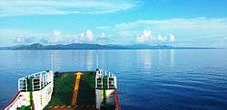
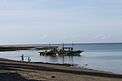
Currently, Marinduque is served by direct Cebu Pacific flights to-and-from Manila and Marinduque Airport which is located in Masiga, roughly between Gasan and Boac. The province is also served by a seaport in Balanacan transporting cargo and passengers to and from Lucena in Quezon province. There is also a daily boat trip from General Luna in Quezon province to Santa Cruz and vice versa which stops at Maniwaya Island to drop off cargo and passengers.
Media
There are four radio stations in the province, three of which are operated by the Radyo Natin Network and the other, FM Nutriskwela Community Radio Station Radyo Kamalindig 94.1 DZNS, by the National Nutrition Council. Radyo Natin Network operates the call sign DZVH at 105.7 MHz on FM radio from Boac, as well as the call sign DWMD 104.5 MHz on FM radio from Santa Cruz and 100.1 FM from Torrijos. As for print media, there is no existing newspapers circulating in the province, aside from broadsheet and tabloid newspapers from Manila. Marinduque News Network, meanwhile, provides provincial and national news and information via the web and social media. In 2018, Marinduque News Network ventured with Lucky Seven Cable Services Corporation, a cable provider in Marinduque to showcase their programs through local cable television. The online news website which was founded by Romeo Mataac, Jr. in 2016 is located in Boac, Marinduque.[17]
There are also existing cable providers and local cable stations operating in several municipalities in the province, namely Lucky Seven Cable Services Corporation (Boac), Marinduque Cable Television, Inc. (Boac), and G.R. CATV Services (Santa Cruz & Torrijos). Aside from these cable stations, there are also distributors of direct-to-home (DTH) satellite TV such as Cignal Digital TV, Dream Satellite TV, G Sat, and Sky Direct who provide television services for its subscribers.
Education
Tertiary
- Buyabod School of Arts and Trades (BSAT) — Buyabod, Santa Cruz
- Educational Systems Technological Institute (ESTI) — Murallon, Boac
- Lighthouse Maritime Schools, Inc. (LMSI) — Boac
- Malindig Institute (MI) — Lapu-Lapu, Santa Cruz
- Marinduque Midwest College (MMC) — Dili, Gasan
- Marinduque State College (MSC) — College of Agriculture in Poctoy, Torrijos
- Marinduque State College (MSC) — College of Fisheries in Banuyo, Gasan
- Marinduque State College (MSC) — Main College Campus in Tanza, Boac
- Marinduque State College (MSC) — Marinduque Community College in Matalaba, Santa Cruz
- Marinduque State College (MSC) — Santa Cruz Annex, Santa Cruz
- Marinduque Victorian College (MVC) — Buenavista
- Saint Mary's College of Boac (SMCB) — Isok, Boac
- Santa Cruz Institute (SCI) — Banahaw, Santa Cruz
- Torrijos Poblacion School of Arts and Trades (TPSAT) — Poctoy, Torrijos
References
- "List of Provinces". PSGC Interactive. Makati City, Philippines: National Statistical Coordination Board. Archived from the original on 11 January 2013. Retrieved 20 February 2013.
- Census of Population (2015). Highlights of the Philippine Population 2015 Census of Population. PSA. Retrieved 20 June 2016.
- Lopez, Cecilio; Constantino, Ernesto (1977). Selected writings of Cecilio Lopez in Philippine linguistics. Archives of Philippine Languages and Dialects, University of the Philippines. p. 4.
- {{cite book |title= The Philippine Islands, 1493-1898 Vol. 38|last=Blair|first=Emma |year=1906 |publisher=Arthur H. Clark Company|isbn= |page=72|url=https://www.gutenberg.org/files/50111/50111-h/50111-h.htm#xd21e706
- Birtle, p. 272
- Foreman, J., 1906, The Philippine Islands, A Political, Geographical, Ethnographical, Social and Commercial History of the Philippine Archipelago, New York: Charles Scribner's Sons
- "Province: Marinduque". PSGC Interactive. Quezon City, Philippines: Philippine Statistics Authority. Retrieved 8 January 2016.
- Birtle, Andrew J. (April 1997). "The U.S. Army's Pacification of Marinduque, Philippine Islands, April 1900 – April 1901". The Journal of Military History (at JSTOR)
|format=requires|url=(help). Society for Military History. 61 (2): 255–282. doi:10.2307/2953967. JSTOR 2953967.
Jessup, Philip Caryl (1938). Elihu Root. Dodd, Mead, & Co./Reprint Services Corp. ISBN 0-7812-4908-2.http://www.namria.gov.ph - Census of Population and Housing (2010). Population and Annual Growth Rates for The Philippines and Its Regions, Provinces, and Highly Urbanized Cities (PDF). NSO. Retrieved 29 June 2016.
- Census of Population and Housing (2010). "Region IV-B (Mimaropa)". Total Population by Province, City, Municipality and Barangay. NSO. Retrieved 29 June 2016.
- "Fact Sheet; Region IV-B; Mimaropa' 2007 Census of Population" (PDF). Philippine Statistics Authority - Region IV-B. Retrieved 8 July 2016.
- "My Marinduque | Travel Blog".
- "Salita Blog: Tagalog verbs". 2007-03-30.
- http://salitablog.blogspot.com
- Pasaylo, Jun (15 April 2012). "Unveiling other treasures of Marinduque". The Philippine Star. Retrieved 27 December 2015.
- "ICHCAP | e-Knowledge Center".
- "About Us". Marinduque News Network. Retrieved 6 March 2016.
- Moriones Festival at travelingmorion.com
External links


- Total Population by Province, City, Municipality and Barangay as of August 1, 2007
Places adjacent to Marinduque | |
|---|---|
Boac (capital) | |
| Municipalities | |

| Authority control |
|
|---|