Amai Manabilang
Amai Manabilang, officially the Municipality of Amai Manabilang (Maranao: Inged a Amai Manabilang; Tagalog: Bayan ng Amai Manabilang), is a 3rd class municipality in the province of Lanao del Sur, Philippines. According to the 2015 census, it has a population of 10,401 people.[3]
Amai Manabilang Bumbaran | |
|---|---|
| Municipality of Amai Manabilang | |
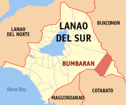 Map of Lanao del Sur with Amai Manabilang highlighted | |
OpenStreetMap 
| |
.svg.png) Amai Manabilang Location within the Philippines | |
| Coordinates: 7°47′07″N 124°40′56″E | |
| Country | |
| Region | Bangsamoro Autonomous Region in Muslim Mindanao (BARMM) |
| Province | Lanao del Sur |
| District | 1st District |
| Barangays | 17 (see Barangays) |
| Government | |
| • Type | Sangguniang Bayan |
| • Mayor | Jamal E. Manabilang |
| • Vice Mayor | Saidamen Leo E. Manabilang |
| • Congressman | Ansaruddin Abdul Malik A. Adiong |
| • Electorate | 5,498 voters (2019) |
| Area | |
| • Total | 544.10 km2 (210.08 sq mi) |
| Population (2015 census)[3] | |
| • Total | 10,401 |
| • Density | 19/km2 (50/sq mi) |
| • Households | 1,776 |
| Economy | |
| • Income class | 3rd municipal income class |
| • Poverty incidence | 53.67% (2015)[4] |
| • Revenue (₱) | 102,277,594.70 (2016) |
| Time zone | UTC+8 (PST) |
| ZIP code | 9320 |
| PSGC | |
| IDD : area code | +63 (0)63 |
| Climate type | tropical climate |
| Native languages | Maranao Tagalog |
| Website | www |
The municipality, formerly Bumbaran, was changed to Amai Manabilang under Muslim Mindanao Act No. 316 on January 22, 2015.[5]
Etymology
Bumbaran is named after the well-known Magalinday Bembaran in the Darangen, a famous Meranau (Maranao) Epic that was justifiably placed in the company of known epics of the world. The scenic beauty of the town resembles the beauty of Magalinday Bembaran.
After the political efforts of Mayor James Manabilang, Bumbaran was renamed into Amai Manabilang, in honor of his own personal ancestor.
Geography
The municipal boundaries are defined as follows: on the east by the municipality of Wao, separated by a straight line 13.65 kilometres (8.48 mi) long, drawn northward from Point 1 to Point 2 on the bank of the Maladugao river 1.5 km. East Sumogot on the Lanao–Bukidnon boundary as point 3; then by straight line following the Lumba - a Bayabao–Wao boundary line. Southward of the intersection of the Lana–Cotabato boundary as point 4; then finally 1.72 km. Eastward following the Lanao–Cotabato boundary to the starting point.[6]
Barangays
Amai Manabilang is politically subdivided into 17 barangays.
- Bagumbayan
- Bandara-Ingud
- Comara (Potre Maamor)
- Francfort
- Lambanogan
- Lico
- Mansilano
- Natangcopan
- Pagalamatan
- Pagonayan
- Penud
- Piagma
- Poblacion (Apartfort)
- Ranao-Baning
- Salam
- Sigu-an
- Sumugot
Climate
The town’s climate is similar to that of Baguio City.
| Climate data for Amai Manabilang, Lanao de Sur | |||||||||||||
|---|---|---|---|---|---|---|---|---|---|---|---|---|---|
| Month | Jan | Feb | Mar | Apr | May | Jun | Jul | Aug | Sep | Oct | Nov | Dec | Year |
| Average high °C (°F) | 24 (75) |
24 (75) |
25 (77) |
25 (77) |
24 (75) |
23 (73) |
23 (73) |
23 (73) |
23 (73) |
23 (73) |
23 (73) |
24 (75) |
24 (74) |
| Average low °C (°F) | 16 (61) |
16 (61) |
17 (63) |
18 (64) |
18 (64) |
18 (64) |
18 (64) |
17 (63) |
18 (64) |
18 (64) |
18 (64) |
17 (63) |
17 (63) |
| Average precipitation mm (inches) | 174 (6.9) |
145 (5.7) |
159 (6.3) |
192 (7.6) |
302 (11.9) |
343 (13.5) |
297 (11.7) |
265 (10.4) |
244 (9.6) |
293 (11.5) |
306 (12.0) |
188 (7.4) |
2,908 (114.5) |
| Average rainy days | 17.4 | 14.4 | 17.4 | 21.3 | 27.6 | 28.0 | 27.9 | 26.9 | 25.0 | 26.9 | 26.0 | 21.1 | 279.9 |
| Source: Meteoblue [7] | |||||||||||||
History
Bumbaran was commonly known before as “Aparport” its seat of government. Its existence came into being when President Ferdinand E. Marcos signed into law on November 17, 1977, Presidential Decree No. 1243 creating Aparport a separate and independent municipality and naming it the Municipality of Bumbaran, separate from the Municipality of Wao, its mother municipality. This was necessary in order to maximize the enforcement of law and order and expedite optimum and sustainable development.[6]
At that time, the municipality consisted of 21 barangays namely: Sumogot, Francfort, Lambanogan, Punud, Comara, Aparport, Paglamatan, Natangcopan, Mansilano, Salam, Bandara-Ingud, Ranao-Ibaning, Bagumbayan, Pagonayan, Piagma, Lico, Siuan, Lama, Borntacan, Miorod, and Someorang.[6] It was reduced to seventeen barangays when President Corazon C. Aquino signed an Executive Order in December 1986 abolishing thousands of barangays in the country which affected barangays Lama, Miorod, Borontacan, and Someorang.
History of Barangay Francfort
The Municipality of Amai Manabilang is composed of two major groups – 99% Muslim Bangsamoro and 1% Catholic. Catholics inhabited barangays Sumogot and Francfort. The Muslim Bangsamoros occupied the rest of the 17 barangays. Due to the aftereffect of the Settler Program,[8] in spite of Meranau protestations dividing their once united province, on the excuse of geographical and cultural reasons, the Sangguniang Bayan, thru Resolution designated Barangay Francfort as Poblacion (Center) for Catholic populace and Barangay Natangcopan as poblacion for the Muslim Bangsamoros. Barangay Natangcopan is an extension of Barangay Aparport, the original seat of government.
Barangay Francfort, together with barangays Sumogot, Aparport and Mansilano were regular barangays of Wao before Bumbaran was created a municipality.
Francfort is named after Mr. Franco and Mr. Fortich, the organizers of the National Reconstruction and Rehabilitation Administrator (NARRA) Settlements Project in the Municipality of Wao. It was created as a regular barangay of Wao in 1965. The first settlers of these barangays were the Ilocanos and Ivatans, followed from 1967 by the Ilongos, Visaya, Kapampangan and other smaller Catholic converted ethnic groups. As anticipated through the Settlements pushing the indigenous away from their land and opportunities, peace and order in the area was interrupted by the Catholic militia ILAGA and the response of the Moro Blackshirts from 1972 to 1976 which caused the evacuation of some residents and damage to properties including the burning of houses.
By November 17, 1977, the Municipality of Bumbaran was created into a separate municipality by virtue of Presidential Decree No. 1234 signed by then President Ferdinand Edralin Marcos, and barangay Francfort was included as one of its regular barangays. Consequently, in the mid1980s, the people returned little by little.
Before Bumbaran was created as a separate municipality, Hadji Acob was the Barangay Chairman of Barangay Francfort; on his death, Efren Vaso succeeded him. In the following barangay election, Columbus Kalaw was elected Barangay Chairman until he was defeated by Wilfredo Barcelona. In 1993, Oscar Baldonasa was elected Chairman and he was re-elected in the 1996 and 2002 barangay elections.
Barangay Francfort is bounded on the East by Maridugao/Maridgaw River; West by Barangay Sumogot; On the south Sumogot river; and on the North by Barangay Lambanogan.
Mountain ranges, hills, plateaus, and flatland characterize the topography of the barangay. It has a vast agricultural land suited for crops like rice, corn, carrots, sugar cane. Its hydrological features comprise rivers like the Maridugao and Sumogot, streams, swamps, creeks and springs.
Barangay Francfort has a total land area of 1,304 hectares. The soil is loam and the climate is temperate. The population is 1,491 according to the 2000 Census, with 298 households.
Demographics
| Year | Pop. | ±% p.a. |
|---|---|---|
| 1980 | 3,401 | — |
| 1990 | 4,341 | +2.47% |
| 1995 | 6,001 | +6.26% |
| 2000 | 6,589 | +2.02% |
| 2007 | 13,297 | +10.17% |
| 2010 | 8,734 | −14.18% |
| 2015 | 10,401 | +3.38% |
| Source: Philippine Statistics Authority[3][9][10][11] | ||
Ethic groups
The Municipality of Amai Manabilang is inhabited by settlers of different origins, like Ilonggos, Ivatans, Ilocano, Bisaya and other smaller ethnic groups that dominated barangays Francfort and Sumugot. This is due to the Settlement Program and Land Tenure Laws[8] of the Republic of the Philippines. The Moro Maranaws who came from the different municipalities of Lanao del Sur and Lanao del Norte inhabited the rest of the seventeen barangays of this municipality. Their source of livelihood is farming, mainly crop production. Having rich soil, the municipality is one of the largest corn producers in the province, only second to its mother municipality of Wao for having vast agricultural land capable of producing variable crops which could give sufficient food and income to the population.
References
- "Municipality". Quezon City, Philippines: Department of the Interior and Local Government. Retrieved 31 May 2013.
- "Province: Lanao del Sur". PSGC Interactive. Quezon City, Philippines: Philippine Statistics Authority. Retrieved 12 November 2016.
- Census of Population (2015). "ARMM – Autonomous Region in Muslim Mindanao". Total Population by Province, City, Municipality and Barangay. PSA. Retrieved 20 June 2016.
- "PSA releases the 2015 Municipal and City Level Poverty Estimates". Quezon City, Philippines. Retrieved 12 October 2019.
- "Muslim Mindanao Autonomy Act No. 316; An Act Changing the Name of the Municipality of Bumbaran in the Province of Lanao del Sur into Municipality of Amai Manabilang, and for Other Purposes" (PDF). Regional Legislative Assembly, Autonomous Region in Muslim Mindanao. Retrieved 27 January 2016.
- "Presidential Decree No. 1243: Creating the Municipality of Amai Manabilang in the Province of Lanao Del Sur". Official Gazette of the Republic of the Philippines. Republic of the Philippines. Retrieved 19 June 2014.
- "Amai Manabilang, Lanao del Sur : Average Temperatures and Rainfall". Meteoblue. Retrieved 19 January 2019.
- http://issuu.com/lgspa/docs/land-tenure-stories-in-central-mindanao
- Census of Population and Housing (2010). "ARMM – Autonomous Region in Muslim Mindanao". Total Population by Province, City, Municipality and Barangay. NSO. Retrieved 29 June 2016.
- Censuses of Population (1903–2007). "ARMM – Autonomous Region in Muslim Mindanao". Table 1. Population Enumerated in Various Censuses by Province/Highly Urbanized City: 1903 to 2007. NSO.
- "Province of Lanao del Sur". Municipality Population Data. Local Water Utilities Administration Research Division. Retrieved 17 December 2016.
External links
- Amai Manabilang Profile at PhilAtlas.com
- Philippine Standard Geographic Code
- Philippine Census Information
- Local Governance Performance Management System
Places adjacent to Amai Manabilang | ||||||||||
|---|---|---|---|---|---|---|---|---|---|---|
| ||||||||||