Luuk, Sulu
Luuk, officially the Municipality of Luuk (Tausūg: Dāira sin Luuk; Tagalog: Bayan ng Luuk), is a 3rd class municipality in the province of Sulu, Philippines. According to the 2015 census, it has a population of 32,162 people.[3]
Luuk | |
|---|---|
| Municipality of Luuk | |
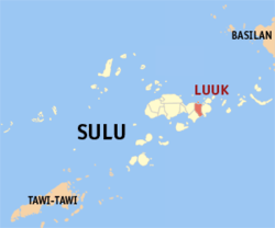 Map of Sulu with Luuk highlighted | |
OpenStreetMap 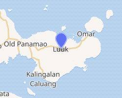
| |
.svg.png) Luuk Location within the Philippines | |
| Coordinates: 5°58′03″N 121°18′48″E | |
| Country | |
| Region | Bangsamoro Autonomous Region in Muslim Mindanao (BARMM) |
| Province | Sulu |
| District | 2nd District |
| Barangays | 12 (see Barangays) |
| Government | |
| • Type | Sangguniang Bayan |
| • Mayor | Maryam N. Arbison |
| • Vice Mayor | Allayon M. Arbison Jr. |
| • Congressman | Munir M. Arbison |
| • Electorate | 19,496 voters (2019) |
| Area | |
| • Total | 313.04 km2 (120.87 sq mi) |
| Population (2015 census)[3] | |
| • Total | 32,162 |
| • Density | 100/km2 (270/sq mi) |
| • Households | 5,279 |
| Economy | |
| • Income class | 3rd municipal income class |
| • Poverty incidence | 51.89% (2015)[4] |
| • Revenue (₱) | 79,036,741.06 (2016) |
| Time zone | UTC+8 (PST) |
| ZIP code | 7404 |
| PSGC | |
| IDD : area code | +63 (0)68 |
| Climate type | tropical climate |
| Native languages | Tausug Tagalog |
| Website | www |
On July 14, 2007, 8 of its barangays were constituted into the separate municipality of Omar, Sulu.
Barangays
Luuk is politically subdivided into 12 barangays.
- Bual
- Guimbaun
- Kan-Bulak
- Kan-Mindus
- Lambago
- Lianutan
- Lingah
- Mananti
- Niog-niog
- Tandu-Bato
- Tubig-Puti (Poblacion)
- Tulayan Island
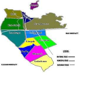
Political map of Luuk
Climate
| Climate data for Luuk, Sulu | |||||||||||||
|---|---|---|---|---|---|---|---|---|---|---|---|---|---|
| Month | Jan | Feb | Mar | Apr | May | Jun | Jul | Aug | Sep | Oct | Nov | Dec | Year |
| Average high °C (°F) | 27 (81) |
27 (81) |
27 (81) |
28 (82) |
28 (82) |
28 (82) |
28 (82) |
28 (82) |
28 (82) |
28 (82) |
28 (82) |
28 (82) |
28 (82) |
| Average low °C (°F) | 27 (81) |
26 (79) |
27 (81) |
27 (81) |
28 (82) |
28 (82) |
27 (81) |
27 (81) |
27 (81) |
27 (81) |
27 (81) |
27 (81) |
27 (81) |
| Average precipitation mm (inches) | 152 (6.0) |
120 (4.7) |
125 (4.9) |
132 (5.2) |
239 (9.4) |
301 (11.9) |
281 (11.1) |
268 (10.6) |
190 (7.5) |
263 (10.4) |
234 (9.2) |
179 (7.0) |
2,484 (97.9) |
| Average rainy days | 17.4 | 14.9 | 15.8 | 15.4 | 22.7 | 24.4 | 25.0 | 23.5 | 20.5 | 22.7 | 21.2 | 18.7 | 242.2 |
| Source: Meteoblue [5] | |||||||||||||
Demographics
| Year | Pop. | ±% p.a. |
|---|---|---|
| 1903 | 700 | — |
| 1918 | 18,351 | +24.33% |
| 1939 | 27,878 | +2.01% |
| 1948 | 16,726 | −5.52% |
| 1960 | 18,852 | +1.00% |
| 1970 | 26,860 | +3.60% |
| 1975 | 21,354 | −4.50% |
| 1980 | 19,669 | −1.63% |
| 1990 | 29,378 | +4.09% |
| 1995 | 31,705 | +1.44% |
| 2000 | 38,819 | +4.44% |
| 2007 | 33,508 | −2.01% |
| 2010 | 29,897 | −4.06% |
| 2015 | 32,162 | +1.40% |
| Source: Philippine Statistics Authority[3][6][7] | ||
References
- "Municipality". Quezon City, Philippines: Department of the Interior and Local Government. Retrieved 31 May 2013.
- "Province: Sulu". PSGC Interactive. Quezon City, Philippines: Philippine Statistics Authority. Retrieved 12 November 2016.
- Census of Population (2015). "ARMM – Autonomous Region in Muslim Mindanao". Total Population by Province, City, Municipality and Barangay. PSA. Retrieved 20 June 2016.
- "PSA releases the 2015 Municipal and City Level Poverty Estimates". Quezon City, Philippines. Retrieved 12 October 2019.
- "Luuk, Sulu : Average Temperatures and Rainfall". Meteoblue. Retrieved 31 January 2019.
- Census of Population and Housing (2010). "ARMM – Autonomous Region in Muslim Mindanao". Total Population by Province, City, Municipality and Barangay. NSO. Retrieved 29 June 2016.
- Censuses of Population (1903–2007). "ARMM – Autonomous Region in Muslim Mindanao". Table 1. Population Enumerated in Various Censuses by Province/Highly Urbanized City: 1903 to 2007. NSO.
External links
- Luuk Profile at PhilAtlas.com
- Philippine Standard Geographic Code
- Philippine Census Information
- Local Governance Performance Management System
Places adjacent to Luuk, Sulu | ||||||||||
|---|---|---|---|---|---|---|---|---|---|---|
| ||||||||||
Jolo (capital) | |
| Municipalities | |
This article is issued from Wikipedia. The text is licensed under Creative Commons - Attribution - Sharealike. Additional terms may apply for the media files.