Poona Bayabao
Poona Bayabao, officially the Municipality of Poona Bayabao (Maranao: Inged a Poona Bayabao; Tagalog: Bayan ng Poona Bayabao), is a 4th class municipality in the province of Lanao del Sur, Philippines. According to the 2015 census, it has a population of 22,227 people.[3]
Poona Bayabao | |
|---|---|
| Municipality of Poona Bayabao | |
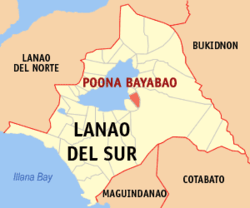 Map of Lanao del Sur with Poona Bayabao highlighted | |
OpenStreetMap 
| |
.svg.png) Poona Bayabao Location within the Philippines | |
| Coordinates: 7°51′N 124°21′E | |
| Country | |
| Region | Bangsamoro Autonomous Region in Muslim Mindanao (BARMM) |
| Province | Lanao del Sur |
| District | 1st District |
| Barangays | 25 (see Barangays) |
| Government | |
| • Type | Sangguniang Bayan |
| • Mayor | Sadat P. Pandi |
| • Vice Mayor | Nadja Panoroganan B. Pacala |
| • Congressman | Ansaruddin Abdul Malik A. Adiong |
| • Electorate | 9,455 voters (2019) |
| Area | |
| • Total | 242.34 km2 (93.57 sq mi) |
| Population (2015 census)[3] | |
| • Total | 22,227 |
| • Density | 92/km2 (240/sq mi) |
| • Households | 2,469 |
| Economy | |
| • Income class | 4th municipal income class |
| • Poverty incidence | 60.91% (2015)[4] |
| • Revenue (₱) | 83,248,723.00 (2016) |
| Time zone | UTC+8 (PST) |
| ZIP code | 9705 |
| PSGC | |
| IDD : area code | +63 (0)63 |
| Climate type | tropical climate |
| Native languages | Maranao Tagalog |
| Website | www |
It is formerly known as Gata.
Barangays
Poona Bayabao is politically subdivided into 25 barangays.
- Ataragadong
- Bangon
- Bansayan
- Bubong-Dimunda
- Bugaran
- Bualan
- Cadayonan
- Calilangan Dicala
- Calupaan
- Dimayon
- Dilausan
- Dongcoan
- Gadongan
- Poblacion (Gata Proper)
- Liangan
- Lumbac
- Lumbaca Ingud
- Madanding
- Pantao
- Punud
- Ragayan
- Rogan Cairan
- Talaguian
- Rogan Tandiong Dimayon
- Taporog
Climate
| Climate data for Poona Bayabao, Lanao de Sur | |||||||||||||
|---|---|---|---|---|---|---|---|---|---|---|---|---|---|
| Month | Jan | Feb | Mar | Apr | May | Jun | Jul | Aug | Sep | Oct | Nov | Dec | Year |
| Average high °C (°F) | 24 (75) |
24 (75) |
25 (77) |
26 (79) |
26 (79) |
25 (77) |
25 (77) |
25 (77) |
25 (77) |
25 (77) |
25 (77) |
25 (77) |
25 (77) |
| Average low °C (°F) | 20 (68) |
20 (68) |
20 (68) |
20 (68) |
21 (70) |
21 (70) |
20 (68) |
20 (68) |
20 (68) |
21 (70) |
20 (68) |
20 (68) |
20 (69) |
| Average precipitation mm (inches) | 159 (6.3) |
143 (5.6) |
166 (6.5) |
183 (7.2) |
357 (14.1) |
414 (16.3) |
333 (13.1) |
309 (12.2) |
289 (11.4) |
285 (11.2) |
253 (10.0) |
166 (6.5) |
3,057 (120.4) |
| Average rainy days | 18.4 | 17.2 | 20.6 | 23.4 | 29.3 | 29.2 | 29.9 | 29.4 | 27.7 | 28.7 | 25.5 | 19.9 | 299.2 |
| Source: Meteoblue [5] | |||||||||||||
Demographics
| Year | Pop. | ±% p.a. |
|---|---|---|
| 1918 | 2,415 | — |
| 1939 | 4,330 | +2.82% |
| 1948 | 3,881 | −1.21% |
| 1960 | 9,179 | +7.44% |
| 1970 | 10,780 | +1.62% |
| 1975 | 12,750 | +3.42% |
| 1980 | 8,955 | −6.82% |
| 1990 | 13,105 | +3.88% |
| 1995 | 15,149 | +2.75% |
| 2000 | 17,390 | +3.00% |
| 2007 | 23,589 | +4.29% |
| 2010 | 19,229 | −7.17% |
| 2015 | 22,227 | +2.80% |
| Source: Philippine Statistics Authority[3][6][7][8] | ||
References
- "Municipality". Quezon City, Philippines: Department of the Interior and Local Government. Retrieved 31 May 2013.
- "Province: Lanao del Sur". PSGC Interactive. Quezon City, Philippines: Philippine Statistics Authority. Retrieved 12 November 2016.
- Census of Population (2015). "ARMM – Autonomous Region in Muslim Mindanao". Total Population by Province, City, Municipality and Barangay. PSA. Retrieved 20 June 2016.
- "PSA releases the 2015 Municipal and City Level Poverty Estimates". Quezon City, Philippines. Retrieved 12 October 2019.
- "Poona Bayabao, Lanao del Sur : Average Temperatures and Rainfall". Meteoblue. Retrieved 27 January 2019.
- Census of Population and Housing (2010). "ARMM – Autonomous Region in Muslim Mindanao". Total Population by Province, City, Municipality and Barangay. NSO. Retrieved 29 June 2016.
- Censuses of Population (1903–2007). "ARMM – Autonomous Region in Muslim Mindanao". Table 1. Population Enumerated in Various Censuses by Province/Highly Urbanized City: 1903 to 2007. NSO.
- "Province of Lanao del Sur". Municipality Population Data. Local Water Utilities Administration Research Division. Retrieved 17 December 2016.
External links
- Poona Bayabao Profile at PhilAtlas.com
- Philippine Standard Geographic Code
- Philippine Standard Geographic Code
- Philippine Census Information
Places adjacent to Poona Bayabao | ||||||||||
|---|---|---|---|---|---|---|---|---|---|---|
| ||||||||||
This article is issued from Wikipedia. The text is licensed under Creative Commons - Attribution - Sharealike. Additional terms may apply for the media files.