Misamis Oriental
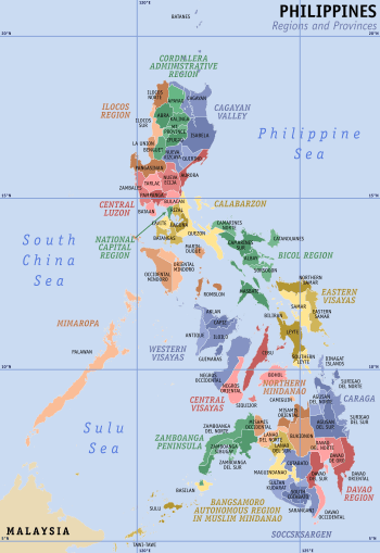
Misamis Oriental (Cebuano: Sidlakang Misamis; Filipino: Silangang Misamis) is a province located in the region of Northern Mindanao in the Philippines. Its capital and provincial center is the city of Cagayan de Oro, which is governed independently from the province.
Misamis Oriental | |
|---|---|
| Province of Misamis Oriental | |
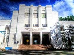 Misamis Oriental Provincial Capitol in Cagayan de Oro | |
 Flag  Seal | |
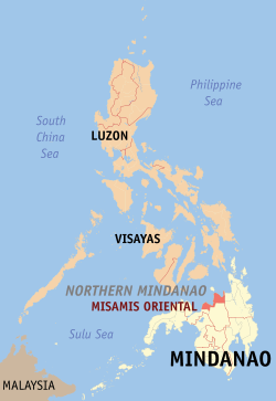 Location in the Philippines | |
| Coordinates: 8°45′N 125°00′E | |
| Country | Philippines |
| Region | Northern Mindanao (Region X) |
| Founded | 1939 |
| Capital | Cagayan de Oro |
| Government | |
| • Type | Sangguniang Panlalawigan |
| • Governor | Yevgeny Vincente "Bambi" B. Emano (NP) |
| • Vice Governor | Jeremy Jonahmar "Jigjag" G. Pelaez (UNA) |
| Area | |
| • Total | 3,131.52 km2 (1,209.09 sq mi) |
| Area rank | 43rd out of 81 |
| (excluding Cagayan de Oro) | |
| Highest elevation | 2,450 m (8,040 ft) |
| Population (2015 census)[2] | |
| • Total | 888,509 |
| • Rank | 30th out of 81 |
| • Density | 280/km2 (730/sq mi) |
| • Density rank | 30th out of 81 |
| (excluding Cagayan de Oro) | |
| Divisions | |
| • Independent cities | |
| • Component cities | |
| • Municipalities | |
| • Barangays |
|
| • Districts |
|
| Time zone | UTC+8 (PST) |
| ZIP code | 9000–9025 |
| IDD : area code | +63 (0)88 |
| ISO 3166 code | PH-MSR |
| Spoken languages | |
| Income classification | 1st class |
| Website | www |
History
Around the 10th Century, the area of what is now Misamis Oriental was under the Indianized Kingdom called the Rajahnate of Butuan.
In the 16th century, Muslims from Malaysia came and then displaced the non-Muslim Lumads northwards as they came to control most of Mindanao, the inhabitants were converted into Islam. As part of Mindanao, the people of the territory were obliged to pay tribute to Muslim rulers.
Province of Cebu
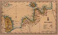
Misamis Oriental shared a history with Misamis Occidental of being part of the Province of Cebu during the Spanish colonial era. In 1818, Misamis was carved out from Cebu to become a separate province with Cagayan de Misamis (Cagayan de Oro) as its capital, and was further subdivided into partidos or divisions: Partido de Cagayan (Division of Cagayan), Partido de Catarman (Division of Catarman), Partido de Dapitan (Division of Dapitan), and Partido de Misamis (Division of Misamis). The new Misamis province was part of the districts of Mindanao during the later part of the 19th Century, with its territory spanning from Dapitan to the west, Gingoog to the East, and as far as Lanao and Cotabato to the south.
Misamis is one of the Spanish-controlled territories vulnerable to Moro raids. The Fuerza de la Concepcion y del Triunfo in Ozamiz was built as a Spanish military installation and one of the staging points in their expeditions against Moros. A fort in Balo-i in present-day Lanao del Norte was also constructed in 1891 on the orders of General Valeriano Weyler in its renewed campaign against the Maranaos. The Fuerza de San Miguel in Iligan was also built, serving as a muster point for Spanish forces in their campaigns in Lanao.
Misamis province
With the organization of the Department of Mindanao and Sulu in 1917, Misamis lost a territory covering Iligan and coastal towns along Iligan and Panguil bays to become part of the Lanao province, making the remaining western and eastern territories of Misamis isolated to each other. Highland areas south of Cagayan de Misamis down to Malaybalay area were carved out to become a sub-province of Bukidnon in 1914, then eventually a full province in 1917.
Legislative Act. No. 3537 approved on 2 November 1929, divided the province of Misamis into two due to the lack of geographic contiguity. It was not until a decade later, on 28 November 1939, that the division between Misamis Oriental and Misamis Occidental was implemented by Act. No. 3777.[3] When Misamis Oriental separated, Don Gregorio Pelaez became its first governor.
World War II
In 1942, at the onset of World War II in the Philippines, Japanese soldiers landed in Misamis Oriental to occupy the region.
Combined American and Philippine Commonwealth forces along with recognised guerrilla fighters liberated Misamis Oriental in 1945.
Modern history
Subsequent creations of new local government units occurred after the war. Lagonglong was a barangay of Balingasag when it was chartered to become a separate municipality in 1949, achieving full municipality status in 1959.
The island of Camiguin was part of the province, and in 1958 it was made into a sub-province. The island eventually separated from Misamis Oriental and achieved regular province status in 1966, with Mambajao as its new provincial capital.
In May 2014 it was reported that an area in Barangay Lapad in Laguindingan, Misamis Oriental, in northern Mindanao, was declared a heritage site. Oyster fossils older than 200,000 years were discovered, according to Balita Pilipinas. Property owner, Raul Ilogon, told Balita Pilipinas that they had been seeing the fossils for 20 years thinking that they were ordinary rocks.[4]
Geography
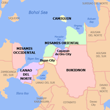
Located in Northern Mindanao, the province borders Bukidnon to the south, Agusan del Norte to the east and Lanao del Norte to the west. On the north is the Bohol Sea with the island-province of Camiguin just off its northern coast.
Misamis Oriental occupies a total land area of 3,131.52 square kilometres (1,209.09 sq mi)[5]. When the independent city of Cagayan de Oro is included for geographical purposes, the province's land area is 3,544.32 square kilometres (1,368.47 sq mi).[5]
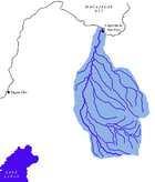
Misamis Oriental, as a coastal province, is dominated by two bays to the north; the Macajalar and the Gingoog Bay.[3] The central portion of the province features several rivers originating from the highlands of Bukidnon, such as the Cagayan.
Administrative divisions
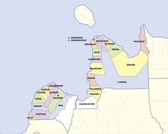
Misamis Oriental comprises 23 municipalities and 2 component cities, which are organized into two legislative districts and further subdivided into 424 barangays. The provincial capital, Cagayan de Oro, is a highly urbanized city that is administered independently from the province.
| |||||||||||||||||||||||||||||||||||||||||||||||||||||||||||||||||||||||||||||||||||||||||||||||||||||||||||||||||||||||||||||||||||||||||||||||||||||||||||||||||||||||||||||||||||||||||||||||||||||||||||||||||||||||||||||||||||||||||||||||||||||||||||||||||||||||||||||||||||||||||||||||||||||||||||||||||||||||||||||||||||||||||||||||||||||||||||||||||||||||||||||||||||||||||||||||
Demographics
| Year | Pop. | ±% p.a. |
|---|---|---|
| 1990 | 525,453 | — |
| 1995 | 587,551 | +2.12% |
| 2000 | 664,338 | +2.67% |
| 2007 | 748,885 | +1.67% |
| 2010 | 813,856 | +3.07% |
| 2015 | 888,509 | +1.69% |
| (excluding Cagayan de Oro City) Source: Philippine Statistics Authority[2][6][6] | ||
The population of Misamis Oriental in the 2015 census was 888,509 people,[2] with a density of 280 inhabitants per square kilometre or 730 inhabitants per square mile. When Cagayan de Oro City is included for geographical purposes, the province's population is 1,564,459 people, with a density of 441/km2 (1,143/sq mi).
Language
Cebuano is the primary spoken language of the province, with the vast majority claiming it to be their mother tongue. Many are fluent in English, which is mainly used for business and in the academe. Maranao is also spoken among the Maranao communities within the province. Other languages that may be heard in the province include Higaonon and Subanon.
Religion
Roman Catholicism predominates in the province with roughly 68% of the population. Other Christian denominations compose most of the minority religions that forms 9% of the Population with 28% belongs Iglesia Filipina Independiente [7] while Islam has a small but steadily increasing number.
Economy
The province is host to industries such as agricultural, forest, steel, metal, chemical, mineral, rubber and food processing. It is home to the 30 square kilometre PHIVIDEC Industrial Estate and the Mindanao International Container Port, all in Tagoloan. Del Monte Philippines, which exports pineapples all over the Asia-Pacific region, has a processing plant in Cagayan de Oro.
On January 10, 2008, Hanjin Heavy Industries and Construction Company of South Korea inked a contract to build a $2 billion shipyard building complex at Villanueva, Misamis Oriental with the PHIVIDEC Industrial Authority. It is bigger than Hanjin's $1 billion shipyard complex in Subic and Olongapo which will hire 20,000 Filipinos to manufacture ship parts. The government declared the 441.8-hectare project site an economic zone (part of 3,000-hectare industrial estate managed by PHIVIDEC).[8]
Government
Executive officials
- Congressmen:
- 1st District of Misamis Oriental with Gingoog City: Christian Unabia (Lakas–CMD)
- 2nd District of Misamis Oriental with El Salvador City: Juliette T. Uy (NUP)
- Governor: Yevgeny Vicente B. Emano (Nacionalista Party)
- Vice Governor: Jigjag G. Pelaez (UNA)
Members of the Sangguniang Panlalawigan
|
|
List of former governors
- Manuel Roa Corrales — 1901-1905
- Apolinar Velez — 1906-1909
- Ricardo Reyes Barrientos — 1910-1912
- Jose Reyes Barrientos — 1912-1916
- Isidro Rillas — 1917-1919
- Juan Valdeconcha Roa — 1919-1921
- Segundo Gaston — 1923-1925
- Don Gregorio A. Pelaez — 1926-1931
- Gregorio Borromeo — 1935-1937
- Don Gregorio A. Pelaez — 1938-1940
- Pedro S.A Baculio — 1941-1945
- Mariano Ope Marbella — 1945
- Ignacio S. Cruz — 1946-1947
- Felicisimo E. Aguilar — 1948-1950
- Paciencio G. Ysalina — 1951-1
— 1954-1961
- Alfonso R. Dadole — 1961-1967
- Pedro N. Roa — 1968-1969
- Concordio C. Diel — September 1969 - March 1974
- Rosauro P. Dongallo — March 1974 - December 1979
- Meynardo A. Tiro — January 1980 - March 2, 1980
- Homobono A. Adaza — March 3, 1980 - July 22, 1984
- Fernando B. Pacana, Jr - July 23, 1984 - March 2, 1986
- Vicente Y. Emano — March 3, 1986 - December 1987[1];
February 1, 1988 - February 2, 1998 - Norris C. Babiera[1] - December 1987 - February 1988
- Ruth de Lara-Guingona — February 2 - June 30, 1998
- Antonio P. Calingin — June 30, 1998 - December 15, 2003
- Miguel C. De Jesus[2] — December 15, 2003 - June 30, 2004
- Oscar S. Moreno — June 30, 2004 - June 30, 2013
- Yevgeny Vincente B. Emano — June 30, 2013 — present
- ^ Appointed
- 2none Acting Capacity
See also
References
- "List of Provinces". PSGC Interactive. Makati City, Philippines: National Statistical Coordination Board. Archived from the original on 11 January 2013. Retrieved 25 June 2014.
- Census of Population (2015). "Region X (Northern Mindanao)". Total Population by Province, City, Municipality and Barangay. PSA. Retrieved 20 June 2016.
- Lancion Jr., Conrado M.; cartography by de Guzman, Rey (1995). "The Provinces; Misamis Oriental". Fast Facts about Philippine Provinces (The 2000 Millenium ed.). Makati, Metro Manila, Philippines: Tahanan Books. p. 106. ISBN 971-630-037-9. Retrieved 28 December 2015.
- "200,000 year-old fossilized oysters found in Misamis Oriental". Gmanetwork.com. 16 May 2014. Retrieved 18 July 2017.
- "Province: Misamis Oriental". PSGC Interactive. Quezon City, Philippines: Philippine Statistics Authority. Retrieved 8 January 2016.
- Census of Population and Housing (2010). "Region X (Northern Mindanao)". Total Population by Province, City, Municipality and Barangay. NSO. Retrieved 29 June 2016.
- "Data" (PDF). psa.gov.ph.
- "Latest News in the Philippines". Manilastandardtoday.com. 10 January 2008. Retrieved 18 August 2017.
External links


- Official website of the Province of Misamis Oriental
- Philippine Standard Geographic Code
- Local Governance Performance Management System
Places adjacent to Misamis Oriental | ||||||||||
|---|---|---|---|---|---|---|---|---|---|---|
| ||||||||||
Cagayan de Oro (capital) | |
| Municipalities | |
| Component cities | |
| Highly urbanized city |
|

| Authority control |
|
|---|