Simunul, Tawi-Tawi
Simunul, officially the Municipality of Simunul, is a 4th class municipality in the province of Tawi-Tawi, Philippines. According to the 2015 census, it has a population of 31,223 people.[3]
Simunul | |
|---|---|
| Municipality of Simunul | |
| Nickname(s): The Birthplace of Islam in the Philippines | |
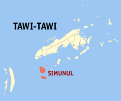 Map of Tawi-Tawi with Simunul highlighted | |
OpenStreetMap 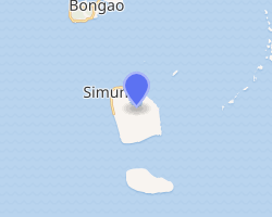
| |
.svg.png) Simunul Location within the Philippines | |
| Coordinates: 4°53′53″N 119°49′17″E | |
| Country | |
| Region | Bangsamoro Autonomous Region in Muslim Mindanao (BARMM) |
| Province | Tawi-Tawi |
| District | Lone District |
| Barangays | 15 (see Barangays) |
| Government | |
| • Type | Sangguniang Bayan |
| • Mayor | Wasilah T. Abdurahman |
| • Vice Mayor | Nazif Ahmad B. Abdurahman |
| • Congressman | Rashidin H. Matba |
| • Electorate | 13,900 voters (2019) |
| Area | |
| • Total | 167.25 km2 (64.58 sq mi) |
| Population (2015 census)[3] | |
| • Total | 31,223 |
| • Density | 190/km2 (480/sq mi) |
| • Households | 3,205 |
| Economy | |
| • Income class | 4th municipal income class |
| • Poverty incidence | 21.81% (2015)[4] |
| • Revenue (₱) | 89,723,132.20 (2016) |
| Time zone | UTC+8 (PST) |
| ZIP code | 7505 |
| PSGC | |
| IDD : area code | +63 (0)68 |
| Climate type | tropical climate |
| Native languages | Sama language Tagalog Sabah Malay |
| Website | www |
The municipality consists of 2 islands: the larger eponymous Simunul Island and Manuk Mangkaw (Manuk Manka) Island, 3.5 kilometres (2.2 mi) to the south.
The language spoken is Sama, also known as Sinama. The first Muslims in the Philippines are said to have arrived at Simunur. The first mosque in the Philippines was built here by Sheik Karimul Makhdum. This mosque is called the Sheik Karimal Makdum Mosque. Inside this mosque stands 4 hags where it is repainted every year.
There are six beaches in Simunur. The majority of the people are Muslims.
Barangays
Simunur is politically subdivided into 15 barangays.
- Bagid
- Bakong
- Doh-Tong
- Luuk Datan
- Manuk Mangkaw
- Maruwa
- Mongkay
- Pagasinan
- Panglima Mastul
- Sokah-Bulan
- Tampakan (Poblacion)
- Timundon
- Tonggusong
- Boheh Indangan
- Ubol
The barangays of Timundon, Manuk Mangkaw, and Luuk Datan are located on Manuk Mangkaw Island; the remaining 12 barangays are located on Simunul Island.
Climate
| Climate data for Simunul, Tawi-Tawi | |||||||||||||
|---|---|---|---|---|---|---|---|---|---|---|---|---|---|
| Month | Jan | Feb | Mar | Apr | May | Jun | Jul | Aug | Sep | Oct | Nov | Dec | Year |
| Average high °C (°F) | 29 (84) |
29 (84) |
29 (84) |
30 (86) |
30 (86) |
30 (86) |
29 (84) |
30 (86) |
30 (86) |
30 (86) |
29 (84) |
29 (84) |
30 (85) |
| Average low °C (°F) | 25 (77) |
24 (75) |
24 (75) |
25 (77) |
25 (77) |
25 (77) |
25 (77) |
25 (77) |
25 (77) |
25 (77) |
25 (77) |
25 (77) |
25 (77) |
| Average precipitation mm (inches) | 157 (6.2) |
115 (4.5) |
123 (4.8) |
96 (3.8) |
136 (5.4) |
120 (4.7) |
104 (4.1) |
89 (3.5) |
86 (3.4) |
131 (5.2) |
151 (5.9) |
159 (6.3) |
1,467 (57.8) |
| Average rainy days | 20.4 | 17.5 | 20.4 | 21.1 | 26.7 | 25.7 | 26.0 | 24.5 | 24.0 | 27.7 | 26.3 | 24.7 | 285 |
| Source: Meteoblue [5] | |||||||||||||
Demographics
| Year | Pop. | ±% p.a. |
|---|---|---|
| 1903 | 1,440 | — |
| 1918 | 5,818 | +9.76% |
| 1939 | 4,980 | −0.74% |
| 1948 | 5,413 | +0.93% |
| 1960 | 8,724 | +4.06% |
| 1970 | 12,135 | +3.35% |
| 1975 | 20,218 | +10.78% |
| 1980 | 26,816 | +5.81% |
| 1990 | 26,491 | −0.12% |
| 1995 | 29,254 | +1.88% |
| 2000 | 31,962 | +1.92% |
| 2007 | 38,239 | +2.50% |
| 2010 | 34,538 | −3.64% |
| 2015 | 31,223 | −1.90% |
| Source: Philippine Statistics Authority[3][6][7][8] | ||
References
- "Municipality". Quezon City, Philippines: Department of the Interior and Local Government. Retrieved 31 May 2013.
- "Province: Tawi-tawi". PSGC Interactive. Quezon City, Philippines: Philippine Statistics Authority. Retrieved 12 November 2016.
- Census of Population (2015). "ARMM – Autonomous Region in Muslim Mindanao". Total Population by Province, City, Municipality and Barangay. PSA. Retrieved 20 June 2016.
- "PSA releases the 2015 Municipal and City Level Poverty Estimates". Quezon City, Philippines. Retrieved 12 October 2019.
- "Simunul, Tawi-Tawi : Average Temperatures and Rainfall". Meteoblue. Retrieved 30 January 2019.
- Census of Population and Housing (2010). "ARMM – Autonomous Region in Muslim Mindanao". Total Population by Province, City, Municipality and Barangay. NSO. Retrieved 29 June 2016.
- Censuses of Population (1903–2007). "ARMM – Autonomous Region in Muslim Mindanao". Table 1. Population Enumerated in Various Censuses by Province/Highly Urbanized City: 1903 to 2007. NSO.
- "Province of Tawi‑tawi". Municipality Population Data. Local Water Utilities Administration Research Division. Retrieved 17 December 2016.
External links
Places adjacent to Simunul, Tawi-Tawi | ||||||||||
|---|---|---|---|---|---|---|---|---|---|---|
| ||||||||||
Bongao (capital) | |
| Municipalities | |