Ditsaan-Ramain
Ditsaan-Ramain, officially the Municipality of Ditsaan-Ramain (Maranao: Inged a Ditsaan-Ramain; Tagalog: Bayan ng Ditsaan-Ramain), is a 3rd class municipality in the province of Lanao del Sur, Philippines. According to the 2015 census, it has a population of 22,299 people.[3]
Ditsaan-Ramain | |
|---|---|
| Municipality of Ditsaan-Ramain | |
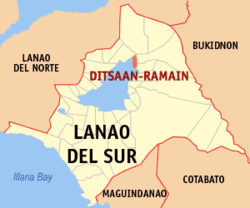 Map of Lanao del Sur with Ditsaan-Ramain highlighted | |
OpenStreetMap 
| |
.svg.png) Ditsaan-Ramain Location within the Philippines | |
| Coordinates: 7°58′N 124°21′E | |
| Country | |
| Region | Bangsamoro Autonomous Region in Muslim Mindanao (BARMM) |
| Province | Lanao del Sur |
| District | 1st District |
| Barangays | 35 (see Barangays) |
| Government | |
| • Type | Sangguniang Bayan |
| • Mayor | Saidamen Hadji A. Adiong |
| • Vice Mayor | Abdul Jabbar G. Dida-agun |
| • Congressman | Ansaruddin Abdul Malik A. Adiong |
| • Electorate | 18,457 voters (2019) |
| Area | |
| • Total | 527.98 km2 (203.85 sq mi) |
| Population (2015 census)[3] | |
| • Total | 22,299 |
| • Density | 42/km2 (110/sq mi) |
| • Households | 1,976 |
| Economy | |
| • Income class | 3rd municipal income class |
| • Poverty incidence | 64.23% (2015)[4] |
| • Revenue (₱) | 96,045,953.99 (2016) |
| Time zone | UTC+8 (PST) |
| ZIP code | 9713 |
| PSGC | |
| IDD : area code | +63 (0)63 |
| Climate type | tropical climate |
| Native languages | Maranao Tagalog |
| Website | www |
Barangays
Ditsaan-Ramain is politically subdivided into 35 barangays.
- Bago a Ingud
- Bayabao
- Buada Babai
- Buadi Alao
- Buadi Oloc
- Pagalongan Buadi Dingan
- Dado
- Dangimprampiai
- Darimbang
- Dilausan
- Ditsaan Proper
- Gadongan
- Pagalongan Ginaopan
- Barimbingan
- Baclayan Lilod
- Baclayan Raya
- Buayaan Lilod
- Bubong Dangiprampiai
- Buayaan Raya
- Linamon
- Lumbatan Ramain
- Buayaan Madanding
- Maindig Ditsaan
- Mandara
- Maranao Timber
- Pagalongan Proper
- Pagalongan Masioon
- Polo
- Pugaan
- Ramain Poblacion
- Ramain Proper
- Rantian
- Sundiga Bayabao
- Talub
- Sultan Pangadapan
- Upper Pugaan
Climate
| Climate data for Ditsaan-Ramain, Lanao de Sur | |||||||||||||
|---|---|---|---|---|---|---|---|---|---|---|---|---|---|
| Month | Jan | Feb | Mar | Apr | May | Jun | Jul | Aug | Sep | Oct | Nov | Dec | Year |
| Average high °C (°F) | 24 (75) |
24 (75) |
25 (77) |
26 (79) |
26 (79) |
25 (77) |
25 (77) |
25 (77) |
25 (77) |
25 (77) |
25 (77) |
25 (77) |
25 (77) |
| Average low °C (°F) | 20 (68) |
20 (68) |
20 (68) |
20 (68) |
21 (70) |
21 (70) |
20 (68) |
20 (68) |
20 (68) |
21 (70) |
20 (68) |
20 (68) |
20 (69) |
| Average precipitation mm (inches) | 159 (6.3) |
143 (5.6) |
166 (6.5) |
183 (7.2) |
357 (14.1) |
414 (16.3) |
333 (13.1) |
309 (12.2) |
289 (11.4) |
285 (11.2) |
253 (10.0) |
166 (6.5) |
3,057 (120.4) |
| Average rainy days | 18.4 | 17.2 | 20.6 | 23.4 | 29.3 | 29.2 | 29.9 | 29.4 | 27.7 | 28.7 | 25.5 | 19.9 | 299.2 |
| Source: Meteoblue [5] | |||||||||||||
Demographics
| Year | Pop. | ±% p.a. |
|---|---|---|
| 1918 | 3,929 | — |
| 1939 | 5,981 | +2.02% |
| 1948 | 9,983 | +5.86% |
| 1960 | 14,310 | +3.05% |
| 1970 | 16,331 | +1.33% |
| 1975 | 20,088 | +4.24% |
| 1980 | 11,024 | −11.30% |
| 1990 | 13,332 | +1.92% |
| 1995 | 16,285 | +3.82% |
| 2000 | 19,157 | +3.54% |
| 2007 | 25,425 | +3.98% |
| 2010 | 20,208 | −8.02% |
| 2015 | 22,299 | +1.89% |
| Source: Philippine Statistics Authority[3][6][7][8] | ||
History
Ditsaan-Ramain is part of the SHAKBA (Bubong, Buadi-Puso, Ditsa-an Ramain and Kapai). SHAKBA is a Maranao word which means links or interconnection. Shakba has many rivers and links to each other and this is where the name derives. Ditsa-an Ramain (shakba) is considered as peaceful among the municipalities of the province.
References
- "Municipality". Quezon City, Philippines: Department of the Interior and Local Government. Retrieved 31 May 2013.
- "Province: Lanao del Sur". PSGC Interactive. Quezon City, Philippines: Philippine Statistics Authority. Retrieved 12 November 2016.
- Census of Population (2015). "ARMM – Autonomous Region in Muslim Mindanao". Total Population by Province, City, Municipality and Barangay. PSA. Retrieved 20 June 2016.
- "PSA releases the 2015 Municipal and City Level Poverty Estimates". Quezon City, Philippines. Retrieved 12 October 2019.
- "Ditsaan-Ramain, Lanao del Sur : Average Temperatures and Rainfall". Meteoblue. Retrieved 24 January 2019.
- Census of Population and Housing (2010). "ARMM – Autonomous Region in Muslim Mindanao". Total Population by Province, City, Municipality and Barangay. NSO. Retrieved 29 June 2016.
- Censuses of Population (1903–2007). "ARMM – Autonomous Region in Muslim Mindanao". Table 1. Population Enumerated in Various Censuses by Province/Highly Urbanized City: 1903 to 2007. NSO.
- "Province of Lanao del Sur". Municipality Population Data. Local Water Utilities Administration Research Division. Retrieved 17 December 2016.
External links
- Ditsaan-Ramain Profile at PhilAtlas.com
- Philippine Standard Geographic Code
- Philippine Census Information
- Local Governance Performance Management System
Places adjacent to Ditsaan-Ramain | ||||||||||
|---|---|---|---|---|---|---|---|---|---|---|
| ||||||||||
This article is issued from Wikipedia. The text is licensed under Creative Commons - Attribution - Sharealike. Additional terms may apply for the media files.