Sitangkai, Tawi-Tawi
Sitangkai, officially the Municipality of Sitangkai, is a 1st class municipality in the province of Tawi-Tawi, Philippines. According to the 2015 census, it has a population of 33,334 people.[3]
Sitangkai | |
|---|---|
| Municipality of Sitangkai | |
 Sitangkai Pier | |
Nickname(s):
| |
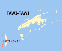 Map of Tawi-Tawi with Sitangkai highlighted | |
OpenStreetMap 
| |
.svg.png) Sitangkai Location within the Philippines | |
| Coordinates: 4°39′42″N 119°23′31″E | |
| Country | |
| Region | Bangsamoro Autonomous Region in Muslim Mindanao (BARMM) |
| Province | Tawi-Tawi |
| District | Lone District |
| Founded | August 26, 1959 |
| Barangays | 9 (see Barangays) |
| Government | |
| • Type | Sangguniang Bayan |
| • Mayor | Tiblan C. Ahaja |
| • Vice Mayor | Serbin C. Ahaja |
| • Congressman | Rashidin H. Matba |
| • Electorate | 23,323 voters (2019) |
| Area | |
| • Total | 792.00 km2 (305.79 sq mi) |
| Population (2015 census)[3] | |
| • Total | 33,334 |
| • Density | 42/km2 (110/sq mi) |
| • Households | 5,331 |
| Economy | |
| • Income class | 1st municipal income class |
| • Poverty incidence | 28.85% (2015)[4] |
| • Revenue (₱) | 155,476,337.88 (2016) |
| Time zone | UTC+8 (PST) |
| ZIP code | 7506 |
| PSGC | |
| IDD : area code | +63 (0)68 |
| Climate type | tropical climate |
| Native languages | Sama language Tagalog Sabah Malay |
| Website | www |
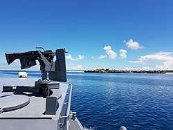
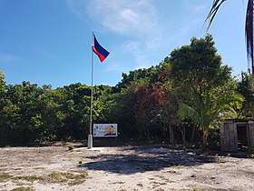
It is the southernmost place in the Philippines.
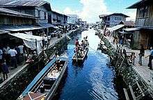
It is called the "Venice of the Philippines"[5] due to the use of boats as primary transportation, although footbridges connect one house to another. The major sources of livelihood are fishing and farming, although there is very sparse agricultural land available.
Barangays
Sitangkai is politically subdivided into 9 barangays.
- Datu Baguinda Putih
- Imam Sapie
- North Larap
- Panglima Alari
- Sipangkot
- Sitangkai Poblacion
- South Larap (Larap)
- Tongmageng
- Tongusong
Climate
| Climate data for Sitangkai, Tawi-Tawi | |||||||||||||
|---|---|---|---|---|---|---|---|---|---|---|---|---|---|
| Month | Jan | Feb | Mar | Apr | May | Jun | Jul | Aug | Sep | Oct | Nov | Dec | Year |
| Average high °C (°F) | 29 (84) |
29 (84) |
29 (84) |
30 (86) |
30 (86) |
30 (86) |
29 (84) |
30 (86) |
30 (86) |
30 (86) |
29 (84) |
29 (84) |
30 (85) |
| Average low °C (°F) | 25 (77) |
24 (75) |
24 (75) |
25 (77) |
25 (77) |
25 (77) |
25 (77) |
25 (77) |
25 (77) |
25 (77) |
25 (77) |
25 (77) |
25 (77) |
| Average precipitation mm (inches) | 157 (6.2) |
115 (4.5) |
123 (4.8) |
96 (3.8) |
136 (5.4) |
120 (4.7) |
104 (4.1) |
89 (3.5) |
86 (3.4) |
131 (5.2) |
151 (5.9) |
159 (6.3) |
1,467 (57.8) |
| Average rainy days | 20.4 | 17.5 | 20.4 | 21.1 | 26.7 | 25.7 | 26.0 | 24.5 | 24.0 | 27.7 | 26.3 | 24.7 | 285 |
| Source: Meteoblue [6] | |||||||||||||
Demographics
| Year | Pop. | ±% p.a. |
|---|---|---|
| 1903 | 1,155 | — |
| 1918 | 6,598 | +12.32% |
| 1939 | 6,812 | +0.15% |
| 1948 | 9,228 | +3.43% |
| 1960 | 10,624 | +1.18% |
| 1970 | 13,738 | +2.60% |
| 1975 | 15,066 | +1.87% |
| 1980 | 27,419 | +12.72% |
| 1990 | 34,493 | +2.32% |
| 1995 | 36,027 | +0.82% |
| 2000 | 52,772 | +8.53% |
| 2007 | 40,641 | −3.54% |
| 2010 | 30,514 | −9.90% |
| 2015 | 33,334 | +1.70% |
| Source: Philippine Statistics Authority[3][7][8][9] | ||
History
The historical Sitangkai group of islands is comprised the islands, areas, and barangays of present Sitangkai and Sibutu municipalities. The islands had been at the crossroads of the sea trade route and were a traditional enclave of the Bajau and Sama people who for centuries had peacefully lived off fishing and trading. The Kadatuan and Kasalipan (Salip/ arabic; Sharif) of Sitangkai and Sibutu were descended from the royalties of Sulu, Sabah, and Sarawak. Historical personalities such as the Datu Iskandar of Sibutu and the Datu Halon of Sitangkai was descended from the Datu Baginda Putih, Datu Baginda Hitam, and the feared Datu Kurunding of Lahat Datu from Borneo (now part of the Malaysian and Indonesian states). In the early 1900s, a man named Lailuddin ibn Jalaluddin from the area of Nunukan, Parang, Sulu was noted to be the first Tausūg to settle in Sitangkai, bringing with him his clan, wealth, and slaves. Together with his sons and nephews, they settled, intermarried, and made alliances with the local traditional leaders and inhabitants. During World War II, Sitangkai and Sibutu, being closer to British Borneo, was targeted by patrols and occasional raids by Japanese Imperial soldiers. Sitangkai nowadays is still a jump off port for traditional traders from Sulu, Zamboanga, mainland Tawi-Tawi going to Sabah and Borneo.
Present day Sitangkai was created as a municipality on August 26, 1959, by virtue of Executive Order No. 355 of President Carlos P. Garcia. On October 21, 2006, with the ratification of Muslim Mindanao Autonomy Act No. 197, 16 of its 25 barangays were transferred to the newly created municipality of Sibutu, all of which are located on Sibutu Island. Most of the residents of present day Sitangkai are settlers from Sulu, Zamboanga, and the Visayas, brought over the years and registered by subsequent competing politicians to add votes for elections. This unjust settling policy has continued unabated over the past decades, destroying the natural demographics of Sitangkai and adjoining islands, thereby affecting the natural resources of the area and disenfranchising the original peaceful Bajau and Sama inhabitants who moved to Zamboanga or Sabah, Malaysia or fled to far away pondohans (shallow sandbars). Lack of opportunities, facilities, the proliferation of illegal arms, drug addiction, and piracy are problems facing Sitangkai today.
References
- "Municipality". Quezon City, Philippines: Department of the Interior and Local Government. Retrieved 31 May 2013.
- "Province: Tawi-tawi". PSGC Interactive. Quezon City, Philippines: Philippine Statistics Authority. Retrieved 12 November 2016.
- Census of Population (2015). "ARMM – Autonomous Region in Muslim Mindanao". Total Population by Province, City, Municipality and Barangay. PSA. Retrieved 20 June 2016.
- "PSA releases the 2015 Municipal and City Level Poverty Estimates". Quezon City, Philippines. Retrieved 12 October 2019.
- https://www.rappler.com/life-and-style/travel/ph-travel/93689-tawi-tawi-travel-mindanao-sights
- "Sitangkai, Tawi-Tawi : Average Temperatures and Rainfall". Meteoblue. Retrieved 30 January 2019.
- Census of Population and Housing (2010). "ARMM – Autonomous Region in Muslim Mindanao". Total Population by Province, City, Municipality and Barangay. NSO. Retrieved 29 June 2016.
- Censuses of Population (1903–2007). "ARMM – Autonomous Region in Muslim Mindanao". Table 1. Population Enumerated in Various Censuses by Province/Highly Urbanized City: 1903 to 2007. NSO.
- "Province of Tawi‑tawi". Municipality Population Data. Local Water Utilities Administration Research Division. Retrieved 17 December 2016.
- "Sitangkai: Seaweed Capital (Tawi-tawi, PH)". No Juan is an Island. Retrieved 15 April 2020.
External links
- Sitangkai Profile at PhilAtlas.com
- Philippine Standard Geographic Code
- Philippine Census Information
Places adjacent to Sitangkai, Tawi-Tawi | ||||||||||
|---|---|---|---|---|---|---|---|---|---|---|
| ||||||||||
Bongao (capital) | |
| Municipalities | |