Parang, Maguindanao
Parang, officially the Municipality of Parang (Maguindanaon: Ingud nu Parang; Iranun: Inged a Parang; Tagalog: Bayan ng Parang), is a 1st class municipality in the province of Maguindanao, Philippines. According to the 2015 census, it has a population of 89,194 people.[3]
Parang | |
|---|---|
| Municipality of Parang | |
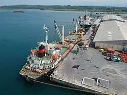 Polloc Port | |
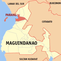 Map of Maguindanao with Parang highlighted | |
OpenStreetMap 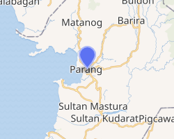
| |
.svg.png) Parang Location within the Philippines | |
| Coordinates: 7°22′28″N 124°16′07″E | |
| Country | |
| Region | Bangsamoro Autonomous Region in Muslim Mindanao (BARMM) |
| Province | Maguindanao |
| District | 1st District |
| Founded | August 18, 1947 |
| Barangays | 25 (see Barangays) |
| Government | |
| • Type | Sangguniang Bayan |
| • Mayor | Cahar P. Ibay |
| • Vice Mayor | Adnan C. Biruar |
| • Congressman | Datu Roonie Q. Sinsuat Sr. |
| • Electorate | 44,457 voters (2019) |
| Area | |
| • Total | 850.78 km2 (328.49 sq mi) |
| Population (2015 census)[3] | |
| • Total | 89,194 |
| • Density | 100/km2 (270/sq mi) |
| • Households | 15,262 |
| Economy | |
| • Income class | 1st municipal income class |
| • Poverty incidence | 44.92% (2015)[4] |
| • Revenue (₱) | 217,769,057.14 (2016) |
| Time zone | UTC+8 (PST) |
| ZIP code | 9604 |
| PSGC | |
| IDD : area code | +63 (0)64 |
| Climate type | tropical climate |
| Native languages | Maguindanao Iranun Tagalog |
| Website | www |
It is bordered to the north by Barira and Matanog, on the east by Buldon, and on the south is Sultan Kudarat. It was created on August 18, 1947, through Executive Order No. 82.
The town was part of the province of Shariff Kabunsuan from October 2006 until its nullification by the Supreme Court in July 2008.
Barangays
Parang is politically subdivided into 25 barangays.
- Bongo Island (Litayen)
- Campo Islam
- Cotongan
- Datu Macarimbang Biruar
- Gadungan
- Gadungan Pedpandaran
- Guiday T. Biruar
- Gumagadong Calawag
- Kabuan
- Landasan (Sarmiento)
- Limbayan
- Macasandag
- Magsaysay
- Making
- Manion
- Moro Point
- Nituan
- Orandang
- Pinantao
- Poblacion
- Poblacion II
- Polloc
- Samberen
- Tagudtongan
- Tuca-Maror
Climate
| Climate data for Parang, Maguindanao | |||||||||||||
|---|---|---|---|---|---|---|---|---|---|---|---|---|---|
| Month | Jan | Feb | Mar | Apr | May | Jun | Jul | Aug | Sep | Oct | Nov | Dec | Year |
| Average high °C (°F) | 28 (82) |
28 (82) |
29 (84) |
29 (84) |
27 (81) |
26 (79) |
26 (79) |
26 (79) |
27 (81) |
26 (79) |
27 (81) |
27 (81) |
27 (81) |
| Average low °C (°F) | 19 (66) |
19 (66) |
19 (66) |
20 (68) |
21 (70) |
20 (68) |
20 (68) |
20 (68) |
20 (68) |
20 (68) |
20 (68) |
19 (66) |
20 (68) |
| Average precipitation mm (inches) | 53 (2.1) |
44 (1.7) |
41 (1.6) |
39 (1.5) |
69 (2.7) |
89 (3.5) |
92 (3.6) |
97 (3.8) |
72 (2.8) |
79 (3.1) |
72 (2.8) |
49 (1.9) |
796 (31.1) |
| Average rainy days | 15.3 | 13.5 | 16.3 | 16.9 | 22.3 | 23.5 | 22.5 | 23.1 | 19.4 | 21.5 | 20.6 | 17.5 | 232.4 |
| Source: Meteoblue [5] | |||||||||||||
Demographics
| Year | Pop. | ±% p.a. |
|---|---|---|
| 1903 | 603 | — |
| 1918 | 1,933 | +8.08% |
| 1939 | 4,495 | +4.10% |
| 1948 | 13,413 | +12.92% |
| 1960 | 37,296 | +8.89% |
| 1970 | 31,667 | −1.62% |
| 1975 | 32,506 | +0.53% |
| 1980 | 46,003 | +7.19% |
| 1990 | 55,355 | +1.87% |
| 1995 | 49,562 | −2.05% |
| 2000 | 60,935 | +4.53% |
| 2007 | 102,247 | +7.40% |
| 2010 | 73,328 | −11.40% |
| 2015 | 89,194 | +3.80% |
| Source: Philippine Statistics Authority[3][6][7][8] | ||
Tourism
A cultural festival is held every August 18 in commemoration of the founding anniversary of Parang. Events are organized by the municipal government with the participation of various stakeholders
Tourist attractions in Parang include:
- Golf course in Camp S.K Pendatun
- Zone Beach
- Punta Beach
- White Sand Beach in Limbayan, Bonggo Island
- Molina-Munoz Farm Resort
- Fruit Bats Sanctuary
- Bacolod street
- Simento white camp
Infrastructure
Transportation
Major sea cargo vessels connect Polloc Port to Manila and other Philippine cities.
Tricycles are the main modes of public transport in the municipality. Several shuttle vans and PUJs provide regular trips to Cotabato City and other municipalities.
Health
- 1 District Hospital
- 1 Rural Health Unit
- 1 Private Hospital
- 1 Medical/Dental Hospital(PNP)
- 1 Medical Diagnostic Laboratory
Utilities
Magelco (Maguindanao Electric Cooperative, Inc.) provides electric power to the locality. Inland barangays use solar power as installed by our donor agencies.
Education
- Tertiary: 3 private schools
- Secondary: 5 public schools;3 private schools
- Elementary: 14 public schools;4 private schools
- Primary: 14 public schools
- Pre-School: 2 public schools;5 private schools
Sister Cities

References
- "Municipality". Quezon City, Philippines: Department of the Interior and Local Government. Retrieved 31 May 2013.
- "Province: Maguindanao". PSGC Interactive. Quezon City, Philippines: Philippine Statistics Authority. Retrieved 12 November 2016.
- Census of Population (2015). "ARMM – Autonomous Region in Muslim Mindanao". Total Population by Province, City, Municipality and Barangay. PSA. Retrieved 20 June 2016.
- "PSA releases the 2015 Municipal and City Level Poverty Estimates". Quezon City, Philippines. Retrieved 12 October 2019.
- "Parang, Maguindanao : Average Temperatures and Rainfall". Meteoblue. Retrieved 19 January 2019.
- Census of Population and Housing (2010). "ARMM – Autonomous Region in Muslim Mindanao". Total Population by Province, City, Municipality and Barangay. NSO. Retrieved 29 June 2016.
- Censuses of Population (1903–2007). "ARMM – Autonomous Region in Muslim Mindanao". Table 1. Population Enumerated in Various Censuses by Province/Highly Urbanized City: 1903 to 2007. NSO.
- "Province of Maguindanao". Municipality Population Data. Local Water Utilities Administration Research Division. Retrieved 17 December 2016.
External links
- Parang Profile at PhilAtlas.com
- Philippine Standard Geographic Code
- Philippine Census Information
- Local Governance Performance Management System
Places adjacent to Parang, Maguindanao | ||||||||||
|---|---|---|---|---|---|---|---|---|---|---|
| ||||||||||
Buluan (capital) | |
| Municipalities |
|
| Independent component city |
|