Pagalungan
Pagalungan, officially the Municipality of Pagalungan (Maguindanaon: Ingud nu Pagalungan; Iranun: Inged a Pagalungan; Tagalog: Bayan ng Pagalungan), is a 1st class municipality in the province of Maguindanao, Bangsamoro, Philippines. According to the 2015 census, it has a population of 39,653 people.[3]
Pagalungan | |
|---|---|
| Municipality of Pagalungan | |
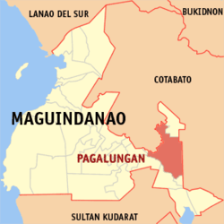 Map of Maguindanao with Pagalungan highlighted | |
OpenStreetMap 
| |
.svg.png) Pagalungan Location within the Philippines | |
| Coordinates: 7°03′33″N 124°41′55″E | |
| Country | |
| Region | Bangsamoro Autonomous Region in Muslim Mindanao (BARMM) |
| Province | Maguindanao |
| District | 2nd District |
| Founded | August 18, 1947 |
| Barangays | 12 (see Barangays) |
| Government | |
| • Type | Sangguniang Bayan |
| • Mayor | Salik P. Mamasabulod |
| • Vice Mayor | Abdilah G. Mamasabulod |
| • Congressman | Esmael G. Mangudadatu |
| • Electorate | 20,049 voters (2019) |
| Area | |
| • Total | 898.76 km2 (347.01 sq mi) |
| Population (2015 census)[3] | |
| • Total | 39,653 |
| • Density | 44/km2 (110/sq mi) |
| • Households | 6,738 |
| Economy | |
| • Income class | 1st municipal income class |
| • Poverty incidence | 53.0% (2015)[4] |
| • Revenue (₱) | 178,882,898.30 (2016) |
| Time zone | UTC+8 (PST) |
| ZIP code | 9610 |
| PSGC | |
| IDD : area code | +63 (0)64 |
| Climate type | tropical climate |
| Native languages | Maguindanao Tagalog |
| Website | www |
Etymology
“Pagalungan” is a Maguindanao word for “mirror”. During the Spanish time, Pagalungan was a mere sitio. There was a small creek in it running towards a small pond called "Migkawa" by the natives of the place. The pond was deep and clear of which the women of the place used it as mirror. Today, the place and the entire municipality are known by the name of “Pagalungan”.
History
Pagalungan was part of Midsayap municipality before it became a regular municipality on August 18, 1947 by virtue of Executive Order No. 41 issued during the administration of then President Manuel A. Roxas. The first appointed and elected mayor was the late Gorgonio P. Initan, a former public school teacher. The succeeding mayors were Datu Tumindig Sultan, 1950-1953; Hadji Abubacar Pendatun, 1954-1962; Bai Tonina P. Matalam Adil, 1963-1971, Datu Malunsing Matalam, 1972-1975; Datu Balumol P. Mama, 1975-1977; Bai Chito Matalam, 1973-1986, Datu Norodin M. Matalam, 1986-1988, Datu Udtog P. Matalam, Jr., 1988- December 16, 1995; Datu Macabangen K. Montawal,Dec.1995-June 2007; Datu Norodin M. Matalam, 2007-2013, and from the later date to present is Datu Salik P. Mamasabulod.
The municipality was the capital of the province of Cotabato,[5] during the time which it encompasses the present-day provinces of Cotabato, Maguindanao and Sultan Kudarat, from 1966 to 1973.[6] During that time, at an estimated population of 30,000-40,000 in 1960, it was also the most populous municipality in the province, almost to be converted into a city during the decade, but internal conflicts and sporadic rebellions in its vicinity especially during 1970s and 1980s resulted in the somewhat stagnant population growth of the town until the foundation of ARMM in 1990 as some of its inhabitants fled towards parts of what was now the SOCCSKSARGEN region, particularly in what is now the Cotabato province, to avoid strife. The municipality ceased to be the capital of Cotabato province in 1973 as it was included as an integral part of the newly created province of Maguindanao, where it currently belongs today.
The municipality of Pagagawan was carved out from Pagalungan town under Muslim Mindanao Autonomy Act No. 95 on July 18, 2000.
Barangays
Pagalungan is politically subdivided into 12 barangays.
- Bagoenged
- Buliok
- Damalasak
- Galakit
- Inug-ug
- Kalbugan
- Kilangan
- Kudal
- Layog
- Linandangan
- Poblacion
- Dalgan
Climate
| Climate data for Pagalungan, Maguindanao | |||||||||||||
|---|---|---|---|---|---|---|---|---|---|---|---|---|---|
| Month | Jan | Feb | Mar | Apr | May | Jun | Jul | Aug | Sep | Oct | Nov | Dec | Year |
| Average high °C (°F) | 32 (90) |
32 (90) |
33 (91) |
33 (91) |
32 (90) |
31 (88) |
30 (86) |
31 (88) |
31 (88) |
31 (88) |
31 (88) |
31 (88) |
32 (89) |
| Average low °C (°F) | 21 (70) |
21 (70) |
21 (70) |
22 (72) |
23 (73) |
23 (73) |
23 (73) |
23 (73) |
23 (73) |
23 (73) |
23 (73) |
22 (72) |
22 (72) |
| Average precipitation mm (inches) | 19 (0.7) |
14 (0.6) |
15 (0.6) |
18 (0.7) |
33 (1.3) |
42 (1.7) |
44 (1.7) |
42 (1.7) |
30 (1.2) |
31 (1.2) |
28 (1.1) |
17 (0.7) |
333 (13.2) |
| Average rainy days | 6.9 | 5.6 | 6.9 | 8.1 | 15.1 | 17.5 | 17.8 | 18.5 | 14.9 | 14.9 | 12.4 | 8.0 | 146.6 |
| Source: Meteoblue [7] | |||||||||||||
Demographics
| Year | Pop. | ±% p.a. |
|---|---|---|
| 1918 | 5,802 | — |
| 1939 | 13,322 | +4.04% |
| 1948 | 34,611 | +11.19% |
| 1960 | 15,672 | −6.39% |
| 1970 | 27,859 | +5.91% |
| 1975 | 24,788 | −2.32% |
| 1980 | 22,747 | −1.70% |
| 1990 | 42,495 | +6.45% |
| 1995 | 46,401 | +1.66% |
| 2000 | 25,908 | −11.74% |
| 2007 | 31,052 | +2.53% |
| 2010 | 31,891 | +0.97% |
| 2015 | 39,653 | +4.23% |
| Source: Philippine Statistics Authority[3][8][9] | ||
References
- "Municipality". Quezon City, Philippines: Department of the Interior and Local Government. Retrieved 31 May 2013.
- "Province: Maguindanao". PSGC Interactive. Quezon City, Philippines: Philippine Statistics Authority. Retrieved 12 November 2016.
- Census of Population (2015). "ARMM – Autonomous Region in Muslim Mindanao". Total Population by Province, City, Municipality and Barangay. PSA. Retrieved 20 June 2016.
- "PSA releases the 2015 Municipal and City Level Poverty Estimates". Quezon City, Philippines. Retrieved 12 October 2019.
- Congress of the Philippines. "Republic Act No. 4849: An Act Creating the Province of South Cotabato". The Corpus Juris. Congress of the Philippines. Retrieved 5 January 2020.
- Patricio P. Diaz. "MIND DA NEWS: Bet? Not End of Capitol Rigodon". MindaNews. Retrieved 23 January 2016.
- "Pagalungan, Maguindanao : Average Temperatures and Rainfall". Meteoblue. Retrieved 19 January 2019.
- Census of Population and Housing (2010). "ARMM – Autonomous Region in Muslim Mindanao". Total Population by Province, City, Municipality and Barangay. NSO. Retrieved 29 June 2016.
- Censuses of Population (1903–2007). "ARMM – Autonomous Region in Muslim Mindanao". Table 1. Population Enumerated in Various Censuses by Province/Highly Urbanized City: 1903 to 2007. NSO.
External links
- Pagalungan Profile at PhilAtlas.com
- Philippine Standard Geographic Code
- Philippine Census Information
- Local Governance Performance Management System
Places adjacent to Pagalungan | ||||||||||
|---|---|---|---|---|---|---|---|---|---|---|
| ||||||||||
Buluan (capital) | |
| Municipalities |
|
| Independent component city |
|