Taraka, Lanao del Sur
Taraka, officially the Municipality of Taraka (Maranao: Inged a Taraka; Tagalog: Bayan ng Taraka), is a 4th class municipality in the province of Lanao del Sur, Philippines. According to the 2015 census, it has a population of 23,644 people.[3]
Taraka | |
|---|---|
| Municipality of Taraka | |
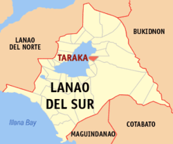 Map of Lanao del Sur with Taraka highlighted | |
OpenStreetMap 
| |
.svg.png) Taraka Location within the Philippines | |
| Coordinates: 7°53′58″N 124°20′53″E | |
| Country | |
| Region | Bangsamoro Autonomous Region in Muslim Mindanao (BARMM) |
| Province | Lanao del Sur |
| District | 1st District |
| Barangays | 43 (see Barangays) |
| Government | |
| • Type | Sangguniang Bayan |
| • Mayor | Nashiba G. Sumagayan |
| • Vice Mayor | Amenodin U. Sumagayan |
| • Congressman | Ansaruddin Abdul Malik A. Adiong |
| • Electorate | 10,030 voters (2019) |
| Area | |
| • Total | 435.40 km2 (168.11 sq mi) |
| Population (2015 census)[3] | |
| • Total | 23,644 |
| • Density | 54/km2 (140/sq mi) |
| • Households | 1,987 |
| Economy | |
| • Income class | 4th municipal income class |
| • Poverty incidence | 66.86% (2015)[4] |
| • Revenue (₱) | 88,193,907.33 (2016) |
| Time zone | UTC+8 (PST) |
| ZIP code | 9712 |
| PSGC | |
| IDD : area code | +63 (0)63 |
| Climate type | tropical climate |
| Native languages | Maranao Tagalog |
| Website | www |
The oldest mosque and the second oldest mosque in the Philippines called Baab-Ur Rahman Masjid built in Lanao del Sur was located in the town.
Barangays
Taraka is politically subdivided into 43 barangays.
- Bandera Buisan
- Boriongan
- Borowa
- Buadi Dingun
- Buadi Amao
- Buadi Amunta
- Buadi Arorao
- Buadi Atopa
- Buadi Dayomangga
- Buadi Ongcalo
- Bucalan
- Cadayonan Bagumbayan
- Caramat
- Carandangan Calopaan
- Datu Ma-as
- Dilabayan
- Dimayon
- Gapao Balindong
- Ilian
- Lumasa
- Lumbac Bagoaingud
- Lumbac Bubong Maindang
- Lumbac Pitakus
- Malungun
- Maruhom
- Masolun
- Moriatao Loksa Datu
- Pagalamatan
- Pindolonan
- Pitakus
- Ririk
- Salipongan
- Lumasa Proper (Salvador Conch
- Sambolawan
- Samporna Salamatollah
- Somiorang Bandingun
- Sigayan Proper
- Sunggod
- Sundig
- Supangan
- Tupa-an Buadiatupa
- Buadi Amunud
- Mangayao
Climate
| Climate data for Taraka, Lanao de Sur | |||||||||||||
|---|---|---|---|---|---|---|---|---|---|---|---|---|---|
| Month | Jan | Feb | Mar | Apr | May | Jun | Jul | Aug | Sep | Oct | Nov | Dec | Year |
| Average high °C (°F) | 24 (75) |
24 (75) |
25 (77) |
26 (79) |
26 (79) |
25 (77) |
25 (77) |
25 (77) |
25 (77) |
25 (77) |
25 (77) |
25 (77) |
25 (77) |
| Average low °C (°F) | 20 (68) |
20 (68) |
20 (68) |
20 (68) |
21 (70) |
21 (70) |
20 (68) |
20 (68) |
20 (68) |
21 (70) |
20 (68) |
20 (68) |
20 (69) |
| Average precipitation mm (inches) | 159 (6.3) |
143 (5.6) |
166 (6.5) |
183 (7.2) |
357 (14.1) |
414 (16.3) |
333 (13.1) |
309 (12.2) |
289 (11.4) |
285 (11.2) |
253 (10.0) |
166 (6.5) |
3,057 (120.4) |
| Average rainy days | 18.4 | 17.2 | 20.6 | 23.4 | 29.3 | 29.2 | 29.9 | 29.4 | 27.7 | 28.7 | 25.5 | 19.9 | 299.2 |
| Source: Meteoblue [5] | |||||||||||||
Demographics
| Year | Pop. | ±% p.a. |
|---|---|---|
| 1918 | 3,471 | — |
| 1939 | 4,996 | +1.75% |
| 1948 | 9,124 | +6.92% |
| 1960 | 15,381 | +4.45% |
| 1970 | 10,644 | −3.61% |
| 1975 | 13,788 | +5.33% |
| 1980 | 13,567 | −0.32% |
| 1990 | 14,765 | +0.85% |
| 1995 | 16,505 | +2.11% |
| 2000 | 18,832 | +2.87% |
| 2007 | 28,196 | +5.72% |
| 2010 | 20,881 | −10.35% |
| 2015 | 23,644 | +2.39% |
| Source: Philippine Statistics Authority[3][6][7][8] | ||
References
- "Municipality". Quezon City, Philippines: Department of the Interior and Local Government. Retrieved 31 May 2013.
- "Province: Lanao del Sur". PSGC Interactive. Quezon City, Philippines: Philippine Statistics Authority. Retrieved 12 November 2016.
- Census of Population (2015). "ARMM – Autonomous Region in Muslim Mindanao". Total Population by Province, City, Municipality and Barangay. PSA. Retrieved 20 June 2016.
- "PSA releases the 2015 Municipal and City Level Poverty Estimates". Quezon City, Philippines. Retrieved 12 October 2019.
- "Taraka, Lanao del Sur : Average Temperatures and Rainfall". Meteoblue. Retrieved 27 January 2019.
- Census of Population and Housing (2010). "ARMM – Autonomous Region in Muslim Mindanao". Total Population by Province, City, Municipality and Barangay. NSO. Retrieved 29 June 2016.
- Censuses of Population (1903–2007). "ARMM – Autonomous Region in Muslim Mindanao". Table 1. Population Enumerated in Various Censuses by Province/Highly Urbanized City: 1903 to 2007. NSO.
- "Province of Lanao del Sur". Municipality Population Data. Local Water Utilities Administration Research Division. Retrieved 17 December 2016.
External links
- Taraka Profile at PhilAtlas.com
- Official website
- Philippine Standard Geographic Code
- Philippine Census Information
- Local Governance Performance Management System
Places adjacent to Taraka, Lanao del Sur | ||||||||||
|---|---|---|---|---|---|---|---|---|---|---|
| ||||||||||
This article is issued from Wikipedia. The text is licensed under Creative Commons - Attribution - Sharealike. Additional terms may apply for the media files.