Maguindanao
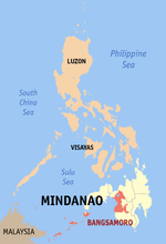
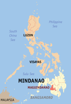
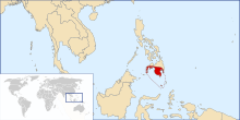
Maguindanao (Tagalog: [maˈɡɪndɐnaʊ], Maguindanaon: Prubinsya nu Magindanaw; Iranun: Perobinsia a Magindanao; Filipino: Lalawigan ng Maguindanao) is a province in the Philippines located in the Bangsamoro Autonomous Region in Muslim Mindanao (BARMM). Since 2014 the provincial capital is Buluan[5] but the legislative branch of the provincial government, the Sangguniang Panlalawigan, convenes in the old provincial capitol in the town of Sultan Kudarat.[6] It borders Lanao del Sur to the north, Cotabato to the east, Sultan Kudarat to the south, and the Illana Bay to the west.
Maguindanao | |
|---|---|
| Province of Maguindanao | |
 Maguindanao new provincial capitol in Buluan | |
 Flag  Seal | |
 Location in the Philippines | |
OpenStreetMap 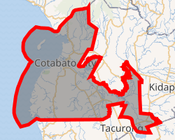
| |
| Coordinates: 7°08′N 124°18′E | |
| Country | Philippines |
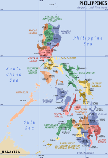
| Region | Bangsamoro |
| Founded | November 22, 1973 |
| Capital | Buluan (executive) Sultan Kudarat (legislative) |
| Government | |
| • Type | Sangguniang Panlalawigan |
| • Governor | Bai Mariam S. Mangudadatu (Nacionalista Party) |
| • Vice Governor | Lester S. Sinsuat (PDP-Laban) |
| Area | |
| • Total | 4,871.60 km2 (1,880.94 sq mi) |
| Area rank | 22nd out of 81 |
| (excluding Cotabato City)[2] | |
| Highest elevation (Mount Lubangan) | 813 m (2,667 ft) |
| Population (2015 census)[3] | |
| • Total | 1,173,933 |
| • Rank | 23rd out of 81 |
| • Density rank | 39th out of 81 |
| (excluding Cotabato City) | |
| Divisions | |
| • Independent cities | 1
|
| • Component cities | 0 |
| • Municipalities | 36
|
| • Barangays |
|
| • Districts | 1st and 2nd districts of Maguindanao (shared with Cotabato City) |
| Time zone | UTC+8 (PHT) |
| IDD : area code | +63 (0)64 |
| ISO 3166 code | PH-MAG |
| Spoken languages | |
| Income classification | 1st class |
| Website | www |
History
Precolonial and Spanish eras
Shariff Mohammed Kabungsuwan of Johore introduced Islam in the area at the end of the 15th century. He subsequently married a local princess from the Maranao Tribe of Malabang and Maguindanao Province, and established the Sultanate of Maguindanao. The Cotabato Valley formed the sultanate's heartland but its influence extended from the Zamboanga Peninsula to Sarangani Bay and Davao.
The Spaniards launched expeditions to subdue the area throughout the colonial era but they never gained control of the region until the middle of the 19th century after the Spaniards established a military post at what is now Barangay Tamontaka, one of the earliest Christian settlements founded south of the Philippines, in present-day Cotabato City.
American Era and World War II
The historical province of Cotabato covered the present area of Maguindanao. In 1903, the American colonial government established the Moro Province and made Cotabato as one of its districts. Upon the conversion of the Moro Province into the Department of Mindanao and Sulu in 1914, the districts were made into provinces.[7][8]
In 1942, the Japanese Imperial forces entered what is now Maguindanao.
In 1945, Maguindanao was liberated by allied Philippine Commonwealth troops and Maguindanaoan guerrilla units after defeating the Japanese Imperial forces in the Battle of Maguindanao during the Second World War.
Creation as a province
The territory of the old province of Cotabato was reduced in 1966 when several of its municipalities were separated from it and constituted into the newly created province of South Cotabato.[9] In 1973, Cotabato was dissolved when it was split to create three new provinces: Maguindanao, (North) Cotabato and Sultan Kudarat.[10]
Maguindanao is the only Muslim-majority province of the four created out of the original Cotabato Province. In 1989, majority of its voters opted to join the Autonomous Region in Muslim Mindanao but Cotabato City did not, which, ironically, has since served as the provisional capital of the Autonomous Region in Muslim Mindanao (ARMM) and hosted line agency offices for the province.
Shariff Kabunsuan creation and nullification
On October 31, 2006, Maguindanao voters approved the creation of a new province to be composed of 10 towns from the province.[11] Of more than 500,000 voters registered, 285,372 favored the creation of the province, and 8,802 voted against it. The new province, Shariff Kabunsuan, established through Muslim Mindanao Autonomy Act No. 201 by the ARMM Regional Legislative Assembly, became the country's 80th province and the 6th in the ARMM. It was composed of the towns of Datu Odin Sinsuat, Kabuntalan, Upi, Sultan Kudarat, Datu Blah T. Sinsuat, Sultan Mastura, Parang, Buldon, Matanog and Barira.[12] However, in July 2008, the Supreme Court, in an 8–6 vote, nullified the province's creation, restoring its municipalities to Maguindanao, ruling that "Only Congress can create provinces and cities because the creation of provinces and cities necessarily includes the creation of legislative districts".[13]
2009 election violence
On November 23, 2009, a 2010 gubernatorial election caravan supporting Esmael Mangudadatu, vice mayor of Buluan, was attacked.[14] Fifty-seven people were killed, including Mangudadatu's wife and sisters, supporters, local journalists, and bystanders.[15] On December 4, 2009, a number of homes belonging to the Ampatuan political family were raided in connection with the massacre.[16]
President Gloria Macapagal Arroyo officially declared martial law in the province of Maguindanao on December 5, 2009, Saturday morning.[17]
In a press conference past 7 am, Executive Secretary Eduardo Ermita announced Proclamation No. 1959 declaring a state of martial law and suspending the privilege of the writ of habeas corpus in the province of Maguindanao, except for certain areas identified as bailiwicks of the Moro Islamic Liberation Front (MILF) separatists.[18]
The declaration of martial law led to the "arrests without warrants" of other members of the Ampatuan clan who have been linked to the November 23 massacre of 58 civilians.[19]
On August 15, 2011, Mangudadatu and his convoy were ambushed as they were on their way to his birthday celebration.
Mamasapano clash
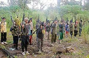
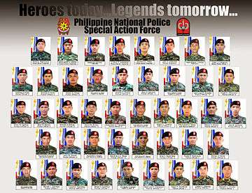
On January 25, 2015, 44 members of the Special Action Force were killed after they killed the Jemaah Islamiyah terrorist Zulkifli Abdhir aka Marwan, by allegedly Moro Islamic Liberation Front and Bangsamoro Islamic Freedom Fighters in Mamasapano, Maguindanao.[20][21]
2016 El Niño
On February 2016, Maguindanao experienced the effects of the 2014–16 El Niño, causing destruction on rice and corn fields due to drought.[22] The province declared a state of calamity in response to the damages caused.[22]
Geography
Maguindanao is situated in the central section of Mindanao, bordered by Lanao del Sur to the north, Cotabato to the east, Sultan Kudarat to the south, and the Illana Bay to the west.
Administrative divisions
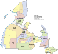
Maguindanao comprises 36 municipalities, further subdivided into 508 barangays. Cotabato City, although geographically grouped with Maguindanao, is administratively independent from the province.
The province is divided into two congressional districts. In October 2006, the first congressional district was split off into a new province, Shariff Kabunsuan. However, the ARMM's Act creating the province was nullified by the Supreme Court in July 2008, on the basis that creation of a province is a function of the Philippine legislature. The area has since reverted to the province of Maguindanao.
- † Capital municipality
- Municipality
- ∗∗ Independent component city (only geographically grouped with the province)
| ||||||||||||||||||||||||||||||||||||||||||||||||||||||||||||||||||||||||||||||||||||||||||||||||||||||||||||||||||||||||||||||||||||||||||||||||||||||||||||||||||||||||||||||||||||||||||||||||||||||||||||||||||||||||||||||||||||||||||||||||||||||||||||||||||||||||||||||||||||||||||||||||||||||||||||||||||||||||||||||||||||||||||||||||||||||||||||||||||||||||||||||||||||||||||||||||||||||||||||||||||||||||||||||||||||||||||||||||||||||||||||||||||||||||||||||||||||||||||||||||||||||||||||||||||||||||||||||||||||||||||||||
The province has seen recent establishments of new municipalities, especially during the 2000s. Then ARMM Regional Legislative Assembly (RLA) secretary Dick Mali said such establishments would help in "decentralizing functions and resources" and provide the people "more efficient public service and governance from their public officials." However, Benedicto Bacani of the Institute of Autonomy and Governance in the Notre Dame University said such acts are methods to prevent potential conflicts between political families by having their own local government units where they can have governmental positions.[27]
Proposed provincial division
House Bill No. 5185 was introduced in the House of Representatives on March 2, 2017 by former Representative Bai Sandra Sema who is barred by law to run for another term in her current district in 2019. It seeks to establish a new province called Maguindanao North, consisting of 11 municipalities and 2 legislative districts, of which Datu Odin Sinsuat will be the designated capital.[28] Her successor, Congressman Datu Roonie Sinsuat, Sr. recently filed a new bill seeking for the same division – only this time, it shall be named Western Maguindanao.
Demographics
| Year | Pop. | ±% p.a. |
|---|---|---|
| 1980 | 452,675 | — |
| 1990 | 630,674 | +3.37% |
| 1995 | 662,180 | +0.92% |
| 2000 | 801,102 | +4.17% |
| 2007 | 1,273,715 | +6.60% |
| 2010 | 944,718 | −10.30% |
| 2015 | 1,173,933 | +4.22% |
| 2007 population figure includes Shariff Kabunsuan. (excluding Cotabato City) Source: Philippine Statistics Authority[3][24][29] | ||
The population of Maguindanao in the 2015 census was 1,173,933 people. When Cotabato City is included for geographical purposes, the province's population is 1,473,371 people.
The majority (64.5 percent) of the people in Maguindanao are Maguindanaoans. The Iranuns which dominate the northern towns of Parang, Barira, Buldon and Matanog make up the second largest group with 18.4 percent. The Tedurays, which are the lumads of the southwestern highlands of the province make up 8.4 percent of the entire population, while Hiligaynons and Cebuanos constitute the remaining significant groups in the province with each making up 3.2 percent of the population.
The main languages are Maguindanao and Iranun. Cebuano, Hiligaynon and Chavacano are also spoken by both Christians and Muslims, with the dialect of Chavacano native to Cotabato City being called Cotabateño, which evolved from the Zamboangueño dialect. Teduray, also native to the province, is spoken in the municipalities of Upi, South Upi, and Datu Blah T. Sinsuat. Also spoken are English and Arabic.
Religion
Maguindanao inhabitants are predominantly practitioners of Islam which comprises 82.99% of the population,[31] majority of which are Sunnites, with a minority of Christians (mostly Roman Catholics), who are mostly Cebuanos, Ilonggos and Chavacanos. Roman Catholics of Maguindanao fall under the jurisdiction of the Roman Catholic Diocese of Kidapawan, a suffragan of the Archdiocese of Cotabato. Iglesia ni Cristo (INC) has several locales in Maguindanao.
Government
Maguindanao is divided into two congressional districts, which elect members to the House of Representatives. For the brief period that the province of Shariff Kabunsuan existed, Maguindanao became a lone-district province. Since the appointment of a new set of provincial officials for the reunified province of Maguindanao by the ARMM Governor in January 2009, the provincial government has reverted to the Sangguniang Panlalawigan district configuration from before Shariff Kabunsuan was created.
Having elected to join the Autonomous Region in Muslim Mindanao (ARMM), Maguindanao also sends six representatives (three per SP district) to the ARMM Regional Legislative Assembly that convenes in Cotabato City.
Provincial capital
.jpg)
When the province was established in 1973, the designated seat of government was the municipality of Maganoy.[10] The first appointed governor, Simeon Datumanong, held office in Limpongo,[32] a former barangay in Maganoy which is now part of the municipality of Datu Hoffer Ampatuan.
Datumanong's successor Zacaria Candao, on the other hand, held office at P.C. Hill,[32] the site of the former headquarters of the Philippine Constabulary[33] in Cotabato City, an autonomous chartered city not under Maguindanao's provincial jurisdiction.
In 1977 following the resignation of Candao, President Ferdinand Marcos moved the province's seat of government to the municipality of Sultan Kudarat (hometown of the newly-appointed governor Sanggacala Baraguir) by virtue of Presidential Decree No. 1170.[34] During his term Baraguir held office at the then-newly-constructed provincial capitol in that municipality's Barangay Simuay Crossing.[32]
The next governor, Sandiale Sambolawan, held office in his hometown of Maganoy following his election to the governorship in 1980.[32] In an attempt to legitimize the restoration of Maganoy's status as the seat of provincial government, Batas Pambansa Blg. 211 was enacted in 1982, but with the explicit provision that the change will only take effect after a plebiscite affirms the transfer.[35] A plebiscite was scheduled for December 18, 1982,[36] but was never administered,[37] thus making the municipality of Sultan Kudarat still capital of Maguindanao by law (de jure), but Maganoy being the capital in practice (de facto). Following the end of the Marcos Regime, the next two governors – Zacaria Candao (1986–1992; 1995–2001) and Norodin Matalam (1992–1995) – both held office in the existing capitol at Sultan Kudarat thereby restoring the municipality's status as both de jure and de facto provincial capital from 1986 to 2001.
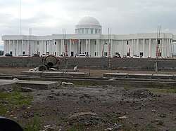
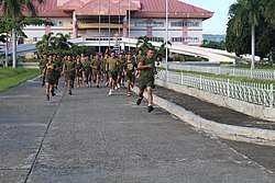
Despite the lack of legal justification in the form of a law amending P.D. No. 1170 of 1977 or the passage of a supporting Sangguaniang Panlalawigan (SP) resolution, the next governor, Andal Ampatuan Sr. (governor from 2001 to 2008), and his successor, son Sajid Ampatuan (2008–2009), held office in the Ampatuan clan stronghold of Shariff Aguak (renamed from Maganoy in 1996[38]), citing security concerns connected to clan rivalry.[6] A new ₱218-million provincial capitol complex, inaugurated in 2009 in the presence of President Gloria Macapagal-Arroyo,[39] was located adjacent to the homes of the Ampatuans,[32] and sat on a piece of Amaptuan clan land that had not been legally deeded to the government.[40] The Ampatuans were even known to spend more time within the "satellite offices" they set up within their private properties, despite though the new capitol being located adjacent to their homes.[41]
Esmael Mangudadatu, who took office after defeating Andal Ampatuan Jr. in the 2010 gubernatorial election, cited security concerns when he decided to work from a "satellite office," named the Rajah Buayan Silongan Peace Center, in his hometown of Buluan;[32] this move was supported by Resolution No. 5, series 2010, of the Sangguniang Panlalawigan (SP) of Maguindanao.[42] SP Resolution No. 78, dated May 3, 2011, further allowed the transfer of the legislative branch of the provincial government (Sangguniang Panlalawigan) to the rehabilitated old capitol site in Barangay Simuay Crossing, Sultan Kudarat.[6] This effectively made both Buluan and Sultan Kudarat – located 120 kilometers apart by road – the seats of the executive and legislative branches of provincial government respectively.[41]
On April 3, 2012, the SP of Maguindanao issued Resolution No. 132, reiterating that the town of Sultan Kudarat was the capital of Maguindanao.[6] However this was superseded by a new resolution passed in 2014 naming Buluan the new capital of Maguindanao.[5] Buluan's Rajah Buayan Silongan Peace Center now serves as the provisional capitol building, pending the completion of the executive building in the new capitol complex.[32] However, the legislative branch of provincial government, the Sangguniang Panlalawigan of Maguindanao, continues to hold sessions in the rehabilitated buildings of the old provincial capitol in Simuay, Sultan Kudarat.[6]
The Ampatuan-built former provincial capitol complex in Shariff Aguak, initially planned to be converted for public school use,[43] has been planned to become the new headquarters of the ARMM's Bureau of Fire Protection and eventually became an infantry brigade of the Philippine Army.[44] However, incumbent governor Bai Mariam Mangudadatu holds her office in the Shariff Aguak Provincial Capitol and plans to convert the Buluan provincial capitol as district hospital.[45]
Musical heritage
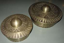
The native Maguindanaon culture revolves around Kulintang music, a specific type of gong music, found among both Muslim and non-Muslim groups of the Southern Philippines.
References
- "ARMM Regional Profile". Regional Board of Investments (RBOI) of the Autonomous Region in Muslim Mindanao (ARMM). Retrieved June 22, 2016. (There seems to be major discrepancies among authoritative sources: 972,904 ha (NSCB); 6,565 km² (Historical Dictionary of the Philippines); 5,176.1 km² (NAMRIA))
- "Area information for Maguindanao". NSCB. Retrieved January 28, 2018.
- Census of Population (2015). Highlights of the Philippine Population 2015 Census of Population. PSA. Retrieved June 20, 2016.
- "Provincial Summary – Number of Provinces, Cities, Municipalities and Barangays, by Region, as of December 31, 2013" (PDF). PSGC Interactive. National Statistical Coordination Board. Archived from the original (PDF) on February 19, 2014. Retrieved May 30, 2014.
- Macabalang, Ali G. (January 19, 2016). "Construction of new Maguindanao capitol complex launched". Manila Bulletin Online. Retrieved August 1, 2016.
- Arguillas, Carolyn O. (June 15, 2012). "Maguindanao inaugurates legislative hall; Sultan Kudarat is back as provincial seat". MindaNews. Retrieved August 1, 2016.
- "Our Province". Province of Cotabato. Retrieved April 27, 2016.
- "Act No. 2711; An Act Amending the Administrative Code". Official Gazette of the Republic of the Philippines. March 10, 1917. Retrieved April 27, 2016.
- "Republic Act No. 4849 – An Act Creating the Province of South Cotabato". Chan Robles Virtual Law Library. July 18, 1966. Retrieved April 15, 2016.
- "Presidential Decree No. 341 – Creating the Provinces of North Cotabato, Maguindanao and Sultan Kudarat". Official Gazette of the Republic of the Philippines. Malacañang, Manila, Philippines. November 22, 1973. Retrieved April 15, 2016.
- Unson, John (October 29, 2006). "Maguindanao split decided in plebiscite". The Philippine Star. Retrieved January 28, 2016.
- "Muslim Mindanao Autonomy Act No. 201; An Act Creating the Province of Shariff Kabunsuan, Providing Funds Therefor, and for Other Purposes" (PDF). Regional Legislative Assembly, Autonomous Region in Muslim Mindanao. Archived from the original (PDF) on February 25, 2017. Retrieved January 27, 2016.
- Llanto, Jesus F. (July 16, 2008). "Supreme Court voids creation of Shariff Kabunsuan". ABS-CBN News. Archived from the original on January 27, 2016. Retrieved January 27, 2016.
- Conde, Carlos H. (November 23, 2009). "21 Reported Dead and 22 Missing in Mass Kidnapping Linked to Philippine Election". The New York Times. Retrieved November 27, 2009.
- Conde, Carlos H. (November 27, 2009). "Philippine Official Says Victims Were Sexually Mutilated". The New York Times. Retrieved November 27, 2009.
- "Officials raid massacre suspects' homes". Radio France Internationale (RFI). December 4, 2009. Retrieved April 15, 2016.
More than 100 soldiers and police wearing body armour and carrying assault rifles raided the home of Andal Ampatuan Jnr and other Ampatuan clan members on Friday. This followed the discovery of a weapons cache on Thursday, believed to have been used in the massacre, near the Ampatuan compound. It is thought there were enough weapons to arm around 500 people.
- "Martial law in Philippines province after massacre". BBC News. December 5, 2009.
- Padua, Reinir (December 6, 2009). "'Martial law a political solution'". The Philippine Star. Retrieved April 15, 2016.
- "Arroyo proclaims martial law in Maguindanao". ABS-CBN News. December 5, 2009.
- "At least 30 elite cops killed in clash with MILF". ABS-CBN News. Retrieved January 25, 2015.
- Arcon, Dennis (January 26, 2015). "PNP-SAF casualties in encounter now 50 – ARMM police chief". Interaksyon. Archived from the original on February 7, 2015. Retrieved January 26, 2015.
- Unson, John (February 5, 2016). "Maguindanao farmers lose crops due to El Niño". Philstar Global. Philstar. Philippine Star. Retrieved February 20, 2016.
- "Province: Maguindanao". PSGC Interactive. Quezon City, Philippines: Philippine Statistics Authority. Retrieved January 8, 2016.
- Census of Population and Housing (2010). Population and Annual Growth Rates for The Philippines and Its Regions, Provinces, and Highly Urbanized Cities (PDF). NSO. Retrieved June 29, 2016.
- "Brief Profile". Provincial Government of Maguindanao. Archived from the original on April 15, 2015. Retrieved April 15, 2016.
Land Area; Maguindanao has a total land area of 597,052.79 hectares.
- "PSGC Interactive; List of Provinces". Philippine Statistics Authority. Archived from the original on January 11, 2013. Retrieved March 29, 2016.
- "'Creating More LGUs Prevents Conflicts in ARMM'". ABS-CBN News. March 30, 2008. Retrieved June 9, 2020.
- Sema, Bai Sandra Sinsuat A. (March 2, 2017). "House Bill No. 5185 – An Act Creating the Province of Maguindanao North" (PDF). Congress of the Philippines. Retrieved September 8, 2017.
- Census of Population and Housing (2010). "ARMM – Autonomous Region in Muslim Mindanao". Total Population by Province, City, Municipality and Barangay. NSO. Retrieved June 29, 2016.
- Table 11. Household Population by Ethnicity and Sex: 2010 (Data excludes Cotabato City)
- Philippine Statistics Authority (July 26, 2017). "Muslim Population in Mindanao (based on POPCEN 2015". Retrieved August 31, 2018.
- Lingao, Ed (April 2013). "Maguindanao's misery: Absentee officials, absence of rage, poverty". Retrieved August 1, 2016.
- McKenna, Thomas M. (1998). Muslim Rulers and Rebels: Everyday Politics and Armed Separatism in the Southern Philippines. University of California Press. p. 327.
- "Presidential Decree No. 1170 – Transferring the seat of government of the province of Maguindanao from the municipality of Maganoy to the Municipality of Sultan Kudarat". Official Gazette of the Republic of the Philippines. Malacañang, Manila, Philippines. July 11, 1977. Retrieved August 1, 2016.
- "Batas Pambansa Blg. 211 – An Act returning the seat of government of the Province of Maguindanao from the Municipality of Sultan Kudarat to the Municipality of Maganoy, repealing for the purpose Presidential Decree numbered eleven hundred and seventy". The Corpus Juris. March 25, 1982. Retrieved August 1, 2016.
- "Proclamation No. 2245, s. 1982 – Declaring December 18, 1982 as the Plebiscite Day for the ratification of the proposal to return the seat of government of the Province of Maguindanao from the Municipality of Sultan Kudarat to the Municipality of Maganoy". Official Gazette of the Republic of the Philippines. Malacañang, Manila, Philippines. November 26, 1982. Retrieved August 1, 2016.
- Unson, John (June 12, 2014). "Law changing Maguindanao's capitol pushed". Philstar.com. Retrieved August 1, 2016.
- "Muslim Mindanao Autonomy Act No. 45 – An Act changing the Name of the Municipality of Maganoy in the Province of Maguindanao into Municipality of Shariff Aguak" (PDF). Regional Legislative Assembly, Autonomous Region in Muslim Mindanao. Retrieved December 23, 2016.
- "Arroyo visits ARMM, pledges more support; praises Ampatuan leadership". Mindanao Examiner. March 31, 2009. Retrieved August 1, 2016.
- Unson, John (January 20, 2016). "Maguindanao gov't starts construction of new capitol complex". The Philippine Star. Retrieved November 4, 2016.
- Arguillas, Carolyn O. (October 19, 2010). "From Ampatuan to Mangudadatu (1): Changing the image of Maguindanao". MindaNews. Retrieved August 1, 2016.
- Arguillas, Carolyn O. (October 20, 2010). "From Ampatuan to Mangudadatu (2): Mobile Capitol". MindaNews. Retrieved August 1, 2016.
- Fernandez, Edwin (June 8, 2014). "Maguindanao provincial building to be converted into school". Philippine Daily Inquirer. Retrieved August 1, 2016.
- "Old Maguindanao capitol in Shariff Aguak town up for conversion to BFP-ARMM headquarters". Radyo Natin. September 29, 2016. Retrieved November 4, 2016.
- Fernandez, Edwin. "Governor-elect to move Maguindanao capitol to old site". Philippine Daily Inquirer. Inquirer Mindanao. Retrieved May 16, 2019.
External links


- COMELEC Resolution No. 8169
- COMELEC Plebiscite Results for 3 new Maguindanao municipalities
- Local Governance Performance Management System
Places adjacent to Maguindanao | ||||||||||
|---|---|---|---|---|---|---|---|---|---|---|
| ||||||||||
Buluan (capital) | |
| Municipalities |
|
| Independent component city |
|