Buluan, Maguindanao
Buluan, officially the Municipality of Buluan (Maguindanaon: Ingud nu Buluan; Iranun: Inged a Buluan; Tagalog: Bayan ng Buluan), is a 4th class municipality and capital of the province of Maguindanao, Philippines. According to the 2015 census, it has a population of 50,008 people.[3]
Buluan | |
|---|---|
| Municipality of Buluan | |
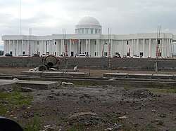 Maguindanao new provincial capitol | |
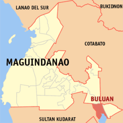 Map of Maguindanao with Buluan highlighted | |
OpenStreetMap 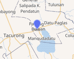
| |
.svg.png) Buluan Location within the Philippines | |
| Coordinates: 6°42′55″N 124°47′08″E | |
| Country | |
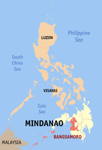
| Region | Bangsamoro Autonomous Region in Muslim Mindanao (BARMM) |
| Province | Maguindanao |
| District | 2nd District |
| Barangays | 7 (see Barangays) |
| Government | |
| • Type | Sangguniang Bayan |
| • Mayor | Babydats D. Mangudadatu |
| • Vice Mayor | Rhamla M. Kadalim |
| • Congressman | Esmael G. Mangudadatu |
| • Electorate | 24,995 voters (2019) |
| Area | |
| • Total | 699.50 km2 (270.08 sq mi) |
| Population (2015 census)[3] | |
| • Total | 50,008 |
| • Density | 71/km2 (190/sq mi) |
| • Households | 7,281 |
| Economy | |
| • Income class | 4th municipal income class |
| • Poverty incidence | 63.12% (2015)[4] |
| • Revenue (₱) | 129,388,653.60 (2016) |
| Time zone | UTC+8 (PST) |
| ZIP code | 9616 |
| PSGC | |
| IDD : area code | +63 (0)64 |
| Climate type | tropical climate |
| Native languages | Maguindanao Iranun Tagalog |
| Website | www |
The town was recognized by the Sangguniang Panlalawigan of Maguindanao as the new (de jure) provincial capital in 2014,[5] a move seen as the solution to the decades-old issue of Maguindanao's lack of a permanent provincial capitol due to local clan politics.[6]
History
Buluan used to comprise a vast area surrounding Lake Buluan when it was created as one of the municipalities of Cotabato on August 8, 1947 by Executive Order No. 82 of Pres. Manuel Roxas.[7] On August 3, 1951, the municipality of Tacurong was created out of its south-western portion.[8] In 1961, its south-eastern portion was separated to form the municipality of Columbio,[9] six years later its southern portion was made into the municipality of Lutayan.[10] It was made part of the province of Maguindanao on November 22, 1973,[11] at the same time ceding its western coast of Lake Buluan to create the municipality of President Quirino,[12] which was made part of Sultan Kudarat province. Its northern portion was made into the municipality of Gen. S. K. Pendatun on April 7, 1991.[13] Its area was further divided on December 30, 2006, when two more municipalities were created out of its territory namely: Mangudadatu and Pandag, losing 8 barangays to each of the two new towns.[14]
In 2014 the Sangguniang Panlalawigan of Maguindanao passed a resolution naming Buluan the new capital of Maguindanao.[5] Pending the completion of the new capitol complex, the provincial governor Esmael Mangudadatu (a Buluan native) will continue to hold office in the town's Rajah Buayan Silongan Peace Center — originally designated as a mere satellite office of the provincial government when Mangudadatu took office in 2010,[15] but since the official designation of Buluan as provincial capital in 2014 has served as the provisional capitol building. However, the legislative branch of provincial government, the Sangguniang Panlalawigan of Maguindanao, continues to hold sessions in the refurbished buildings of the old provincial capitol in Simuay, Sultan Kudarat, by virtue of Sangguniang Panlalawigan Resolution No. 78 dated May 3, 2011.[16] The old provincial capitol complex, built next to the previous governor's properties in Shariff Aguak, was converted for public use.[17]
Barangays
Buluan is politically subdivided into 7 barangays.[18]
- Digal
- Lower Siling
- Maslabeng
- Poblacion Mopac
- Popol
- Talitay
- Upper Siling
Climate
| Climate data for Buluan, Maguindanao | |||||||||||||
|---|---|---|---|---|---|---|---|---|---|---|---|---|---|
| Month | Jan | Feb | Mar | Apr | May | Jun | Jul | Aug | Sep | Oct | Nov | Dec | Year |
| Average high °C (°F) | 31 (88) |
31 (88) |
32 (90) |
32 (90) |
31 (88) |
30 (86) |
30 (86) |
30 (86) |
30 (86) |
30 (86) |
30 (86) |
31 (88) |
31 (87) |
| Average low °C (°F) | 23 (73) |
23 (73) |
23 (73) |
24 (75) |
24 (75) |
24 (75) |
24 (75) |
24 (75) |
24 (75) |
24 (75) |
24 (75) |
24 (75) |
24 (75) |
| Average precipitation mm (inches) | 64 (2.5) |
45 (1.8) |
59 (2.3) |
71 (2.8) |
140 (5.5) |
179 (7.0) |
192 (7.6) |
198 (7.8) |
163 (6.4) |
147 (5.8) |
113 (4.4) |
66 (2.6) |
1,437 (56.5) |
| Average rainy days | 12.2 | 10.3 | 12.7 | 15.7 | 26.0 | 27.4 | 28.1 | 28.2 | 26.0 | 26.7 | 22.9 | 16.6 | 252.8 |
| Source: Meteoblue [19] | |||||||||||||
Demographics
| Year | Pop. | ±% p.a. |
|---|---|---|
| 1918 | 5,263 | — |
| 1948 | 61,934 | +8.57% |
| 1960 | 73,201 | +1.40% |
| 1970 | 49,158 | −3.90% |
| 1975 | 41,357 | −3.41% |
| 1980 | 38,313 | −1.52% |
| 1990 | 53,143 | +3.33% |
| 1995 | 38,695 | −5.77% |
| 2000 | 51,098 | +6.14% |
| 2007 | 32,310 | −6.13% |
| 2010 | 38,106 | +6.19% |
| 2015 | 50,008 | +5.31% |
| Source: Philippine Statistics Authority[3][20][21][22] | ||
References
- "Municipality". Quezon City, Philippines: Department of the Interior and Local Government. Retrieved 31 May 2013.
- "Province: Maguindanao". PSGC Interactive. Quezon City, Philippines: Philippine Statistics Authority. Retrieved 12 November 2016.
- Census of Population (2015). "ARMM – Autonomous Region in Muslim Mindanao". Total Population by Province, City, Municipality and Barangay. PSA. Retrieved 20 June 2016.
- "PSA releases the 2015 Municipal and City Level Poverty Estimates". Quezon City, Philippines. Retrieved 12 October 2019.
- Macabalang, Ali G. (19 January 2016). "Construction of new Maguindanao capitol complex launched". Manila Bulletin. Retrieved 1 August 2016.
- Unson, John (20 January 2016). "Maguindanao gov't starts construction of new capitol complex". The Philippine Star. Retrieved 1 August 2016.
- Commission on Audit. "Executive Summary of the 1999 Annual Audit Report on the Municipality of Buluan". Retrieved 2008-05-19.
- National Statistical Coordination Board - Region XII. "Brief Overview of Tacurong City". Retrieved 2008-05-19.
- Commission on Audit (2004-06-02). "Glimpse of Columbio". Archived from the original on 2004-12-07. Retrieved 2008-05-19.
- Chan Robles Virtual Law Library (1998-07-19). "Republic Act No. 4868". Retrieved 2008-05-19.
- Chan Robles Virtual Law Library (1998-07-19). "Presidential Decree No. 341". Retrieved 2008-05-18.
- Chan Robles Virtual Law Library (1998-07-19). "Presidential Decree No. 339". Retrieved 2008-05-18.
- Philippine Statistics Authority (2001-04-23). "Census 2000 Final Counts". Archived from the original on 2007-11-26. Retrieved 2008-05-19.
- National Statistical Coordination Board (2007-03-26). "2007 Factsheet - Did you know that... ARMM now has six provinces". Retrieved 2008-05-19.
- Lingao, Ed (April 2013). "Maguindanao's misery: Absentee officials, absence of rage, poverty". Archived from the original on 15 September 2016. Retrieved 1 August 2016.
- Arguillas, Carolyn O. (15 June 2012). "Maguindanao inaugurates legislative hall; Sultan Kudarat is back as provincial seat". MindaNews. Retrieved 1 August 2016.
- Fernandez, Edwin (8 June 2014). "Maguindanao provincial building to be converted into school". Philippine Daily Inquirer. Retrieved 1 August 2016.
- National Statistical Coordination Board. "PSGC Interactive: Municipality/City: BULUAN". Archived from the original on 2007-11-24. Retrieved 2008-05-19.
- "Buluan, Maguindanao : Average Temperatures and Rainfall". Meteoblue. Retrieved 19 January 2019.
- Census of Population and Housing (2010). "ARMM – Autonomous Region in Muslim Mindanao". Total Population by Province, City, Municipality and Barangay. NSO. Retrieved 29 June 2016.
- Censuses of Population (1903–2007). "ARMM – Autonomous Region in Muslim Mindanao". Table 1. Population Enumerated in Various Censuses by Province/Highly Urbanized City: 1903 to 2007. NSO.
- "Province of Maguindanao". Municipality Population Data. Local Water Utilities Administration Research Division. Retrieved 17 December 2016.
External links
- Buluan Profile at PhilAtlas.com
- Philippine Standard Geographic Code
- Philippine Census Information
- Local Governance Performance Management System
Places adjacent to Buluan, Maguindanao | |
|---|---|
Buluan (capital) | |
| Municipalities |
|
| Independent component city |
|